-
 Temperatures climbed well into the upper 80s this week in the Lehigh Valley, teasing that classic summer milestone — the first 90-degree day of the year.
 -
Smoke drifted over the Great Lakes on Monday night and pushed east, the National Weather Service said, with forecasters warning it will result in smokier skies for the Lehigh Valley and large swaths of the eastern U.S. on Tuesday.
-
The National Weather Service said the haze could be more apparent toward the late afternoon and evening hours, particularly at sunset.
-
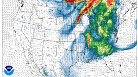
Overall, 31 of the region’s 35 major climate sites were wetter than normal, with 22 of them experiencing one of their 20 wettest May 1-15 periods. Allentown took the top spot, experiencing its wettest May 1-15 ever.
-
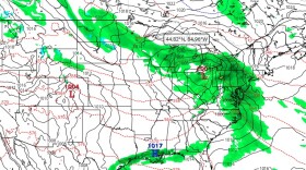
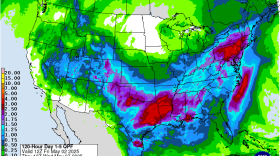
Right on the heels of Friday’s warm front, the Lehigh Valley will see a cold front move in Saturday. Rounds of storms are expected both days, forecasters say.
-
The tornado that touched down Tuesday evening in Bangor has been categorized by the National Weather Service, according to a statement issued Wednesday. The agency estimated peak winds reached 80 to 90 mph with a path length of about 1.50 miles and a maximum path width of 100 yards.
-
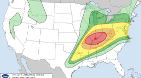
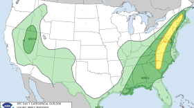
“An isolated tornado is not entirely out of the question," the National Weather Service said of Saturday's threat. But non-English speakers may not be aware of warnings for severe weather.
-
Excessive rainfall during drought can trigger flash flooding, forecasters say. The concern is that prolonged dry conditions can make the soil hydrophobic, meaning it repels water.
-
If Mother Nature has anything to say about it, this could be an abbreviated peak bloom for the cherry blossoms in the Lehigh Valley and surrounding areas.
-
Cloud cover is likely to limit thunderstorm development Monday by acting as a cap, preventing the upward movement of warm, moist air needed to fuel thunderstorms.

Your Local News | Allentown, Bethlehem & Easton
Play Live Radio
Next Up:
0:00
0:00
Available On Air Stations