

BETHLEHEM, Pa. — Summer tried to make its entrance in the Lehigh Valley this week, but Mother Nature fell just short of truly bringing the heat.
Temperatures climbed well into the upper 80s, teasing that classic summer milestone — the first 90-degree day of the year.
The heat index — which combines heat and humidity — briefly hit 91 degrees Thursday afternoon, giving residents a taste of what’s likely to come.National Weather Service
According to the National Weather Service, the thermometer topped out at 88 degrees Thursday afternoon at Lehigh Valley International Airport, narrowly missing the mark.
It was the second straight day of near-90 weather. Wednesday reached 87 degrees, making it the warmest day of 2025 to that point.
The heat index — which combines heat and humidity — briefly hit 91 degrees Thursday afternoon, giving residents a taste of what’s likely to come.
That kind of heat is typical for mid-to-late June, but forecasters say it won’t stick around. A cooler pattern is expected to take over through the weekend, with highs dipping into the low 70s by Sunday.
Even next week, temperatures may only reach the 80s, forecasters say.
A late start to the heat
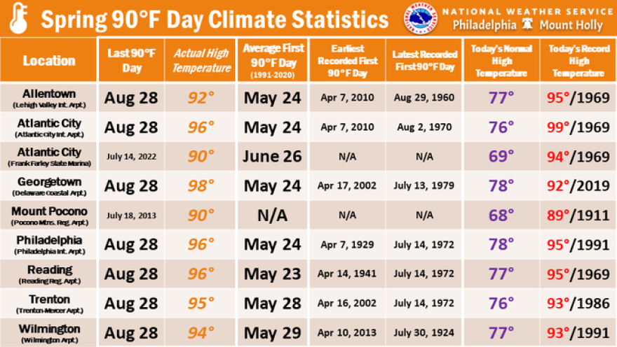
Historically, the Lehigh Valley usually sees its first 90-degree day by May 24. In fact, the earliest it’s ever happened was April 7, 2010.
And in recent decades, those hot days are arriving earlier — one of many signs of Pennsylvania’s changing climate.
But this year has been a different story.
June began more than 8 degrees cooler than normal. Overnight lows dipped into the 40s four nights in a row, and most of late May felt similarly chilly.
Meteorologist Bobby Martrich of EPAWA said persistent troughs and upper-level lows — weather patterns more typical of early spring — have lingered into June.
“Usually that’s like an early-mid spring thing,” Martrich said.
He said the Lehigh Valley hasn’t dealt with too many ridges — elongated areas of high atmospheric pressure, often associated with clear, dry and warm weather.
“That does two things — keeps it cooler overall like we saw in late May, and ridges will prevent excessive rainfall," he said. "Troughs are the opposite, hence the crazy wet May."
So when will it finally hit 90?
As for hitting 90? That might take a while.
Unlike last year — when the Lehigh Valley had a six-day heat wave starting June 18 and was racking up 90-degree days by early July — this summer looks much milder, at least for now.
Martrich said Friday that he wouldn’t be surprised if June passes without a single 90-degree day.
“If I’m placing bets, it’s for July for that to occur — and even then, not that many.”EPAWA meteorologist Bobby Martrich on the potential for 90-degree days
“If I’m placing bets,” he said, “it’s for July for that to occur — and even then, not that many.”
Long-range pattern outlooks from EPAWA covering mid-June through mid-July suggest the region will be "largely temperate and absent of extremes," with a pattern that could feature fast-moving cold fronts and show increased frequency of thunderstorm activity, "but also limit the opportunity for temperature extremes both hotter and cooler" except in transient cases.
So while summer solstice may be on the calendar, the sweltering heat of the season hasn’t quite shown up in the forecast.
Yet.
