
BETHLEHEM, Pa. — Warm, humid and summerlike conditions will trigger bouts of heavy rain and flash flooding over the next few days and beyond, forecasters say.
“We have one heck of a mess heading toward us,” EPAWA meteorologist Bobby Martrich said to kick off his Friday video update.
“It’s going to be notably warmer and much more humid,” with dew points in the upper 50s to lower 60s across the region on Friday, and temperatures in the low- to mid-80s, Martrich said.
“You’re going to feel the humidity,” he warned. He said it will open the door for a pattern of what looks like several days of heavy rain and occasional strong to severe storms.
The National Weather Service said isolated to widely scattered showers and thunderstorms are possible Friday night.
“While there will be at least some chance for storms areawide, the greatest chance appears to be near and northwest of the I-95 corridor,” the latest NWS forecast discussion said.
Weekend, unsettled pattern ahead
“Saturday is going to be the same thing,” Martrich said, with partly to mostly cloudy skies through much of the day.
“Once we get into the afternoon, though, look what happens,” he said, highlighting the potential for a line of storms moving through the area.
“These are going to be heavy rain producers,” he said. “There’s very high precipitable water content in the atmosphere because it’s so humid.
“You get into this soupy pattern and you get some very slow moving storm motions.” He said some storms may be “a little bit gusty and feisty.”EPAWA meteorologist Bobby Martrich
“You get into this soupy pattern and you get some very slow moving storm motions.” He said some storms may be “a little bit gusty and feisty.”
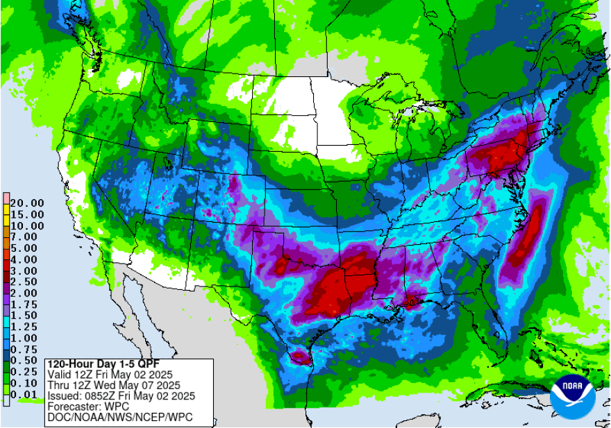
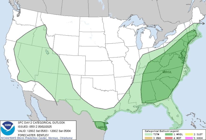
The Storm Prediction Center has much of the region at a marginal risk (1 out of 5) of severe weather, but Martrich warned the amount of rain falling could be a bigger issue.
“These have the potential to train over the same area, so you can get some heavy rain,” he said.
“It can be one of those deals where somebody might get a couple inches of rain out of this and just from this, because you have the same storms training over the same areas over and over again.”
The Lehigh Valley is at a marginal risk of excessive rainfall, which comes at a time when the area has been mired in drought.
The concern is that prolonged dry conditions can make the soil hydrophobic, meaning it repels water.
That means when heavy rain falls, it tends to flow over the surface rather than soaking in, leading to rapid accumulation and potential flash flooding.
Sunday through Tuesday
The Sunday through Tuesday period will bring the potential for a few severe thunderstorms each day, the weather service said, with damaging winds being the main threat.
“This is going to be a long-duration deal, with some times that the rain is heavier than others.”EPAWA meteorologist Bobby Martrich
“This is going to be a long-duration deal,” Martrich warned, “with some times that the rain is heavier than others.”
The pattern into which we'll be locked in is due to something called an omega block, which is when high pressure over the middle of the country has low pressure on either side.
That stubborn setup blocks the normal flow of the jet stream, and to the west and east of the block we typically see slow-moving areas of low pressure — leading to many days of unsettled weather.
“While precipitation may diminish for a time behind the Sunday evening push, another round may develop later Monday into Monday night, with another risk of widespread showers and T-storms with locally heavy rain,” the weather service said.
“Thus, the risk of flooding will become even more pronounced in any areas which by this time have already had significant rainfall.
"Exactly where that ends up being, not sure yet, but odds favor the areas northwest of I-95.”
Martrich said rainfall totals suggest a widespread 2 to 4 inches could fall in the region over the next four to five days.
