-
 “This weekend will feature an early-summer like weather pattern,” the National Weather Service said, highlighting dry conditions and a mix of sun and clouds expected Saturday afternoon.
 -
The spring equinox officially arrived at 5:01 a.m. Thursday, but the upcoming pattern is cold, blustery and rainy for the Lehigh Valley and the rest of the region.
-
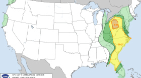
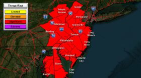
A destructive storm system moving up the coast is expected to hit the Lehigh Valley on Sunday evening. The area likely won't see any severe weather today, but it is just bordering the potential to, graphics from the National Weather Service show.
-
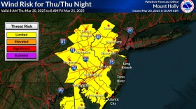
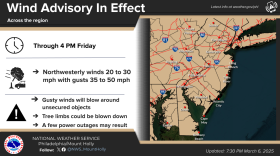
A wind advisory was extended until 4 p.m. Friday in the Lehigh Valley and surrounding areas, with winds 15 to 25 mph and gusts of 35 to 50 mph expected.
-
Severe storms will affect much of the East on Wednesday, forecasters say, with the Lehigh Valley likely to see heavy rain in the afternoon hours and through the evening rush.
-
The inaugural meeting of the PA Road Salt Action Working Group was held Tuesday afternoon. The group aims to reduce salt pollution as well as promote responsible road salt application practices statewide.
-
A multi-day severe weather event will unfold as a strong storm system marches from the Central Plains to the Great Lakes on Monday and Tuesday before targeting the Lehigh Valley on Wednesday.
-
High wind warnings were converted to wind advisories for most areas early Monday, but not before thousands of utility customers across the region lost power overnight.
-
Power outages, high wind gusts expected in the Lehigh Valley tonight. Then more snow later this weekThe area could see wind gusts up to 60 mph tonight, with windy conditions persisting into tomorrow, including frigid wind chills. Plus, a look at what forecasters are saying about the potential for snow later this week.
-
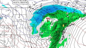
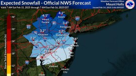
The Lehigh Valley will begin the weekend under a winter weather advisory in effect from noon Saturday until 1 a.m. Sunday.

Your Local News | Allentown, Bethlehem & Easton
Play Live Radio
Next Up:
0:00
0:00
Available On Air Stations