Bethlehem Live Weather Camera
This is a live look at SteelStacks in Bethlehem outside of our studio.

sluhn.org
WEATHER-RELATED STORIES FROM THE NEWSROOM
-
 After temperatures that felt more like October than August last week, forecasters say the Lehigh Valley will return to summer in a big way this week. Near-record heat is expected Wednesday.
 -
“We have cooler air coming in," Lehigh Valley meteorologist Bobby Martrich said in his latest update. "Cooler air and refreshing air coming in for the next several days.” How far will temperatures fall?
-
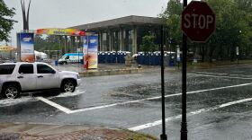
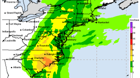
More than 5 inches of rain was reported to have fallen in parts of the Lehigh Valley on Sunday, according to official data from the National Weather Service.
-
Swaths of the Lehigh Valley were inundated by heavy rainfall on Sunday, leading to flash floods and prompting water rescues. Some areas received nearly 5 inches of rain, with a secondary front set to bring more on Monday.
-
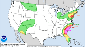
The arrival of a slow-moving system will make for an unsettled weekend, forecasters say, with an excessive rainfall risk and potential flash flooding Sunday for the Lehigh Valley.
-
In the home stretch of summer, is the worst of the heat behind us? Here’s where things stand in the Lehigh Valley as we look ahead — and enter the peak of hurricane season.
-
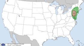
The Storm Prediction Center has extended a tornado watch until 10 p.m., and the National Weather Service has issued a flash flood warning until 6:45 p.m.
-
Join Megan Frank at 9:30 a.m. and 6:30 p.m. every Friday for Insights with LehighValleyNews.com on WLVR. This week, she's joined by Managing Producer Stephanie Sigafoos and Northampton County reporter Ryan Gaylor.
-
With Tropical Storm Debby on approach to the region, forecasters continue to refine key messaging on what the Lehigh Valley can expect. We're at a 'slight' risk for severe weather, with tornadoes the main threat. Both Lehigh and Northampton counties are also under a flood watch.
-
A cold front interacting with moisture from Tropical Storm Debby left the region awash in heavy rain on Tuesday, triggering flash flood warnings and water rescues. More rain will come Friday as Debby moves over the area.
-
The Lehigh Valley will begin to see impacts from Tropical Cyclone Debby on Tuesday, forecasters warn, calling expected rainfall a ‘predecessor’ event as the storm begins to crawl up the coast.
-
Following a severe thunderstorm yesterday, the Lehigh Valley should brace for more intense weather