BETHLEHEM, Pa. — With Tropical Storm Debby approaching the region, forecasters continue to refine key messaging on what the Lehigh Valley can expect on Friday.
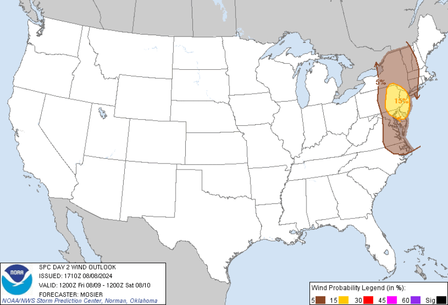
Early Thursday evening, the Storm Prediction Center shifted the severe weather threat from marginal (1 out of 5) to slight (2 out of 5) and increased the tornado risk to 5% probability.
The greatest severe potential is expected from eastern Pennsylvania into New Jersey and the northern Delmarva Peninsula, the SPC said in its update.
“There’s a double-edged sword (to the storm) that’s good and bad,” EPAWA meteorologist Bobby Martrich told LehighValleyNews.com.
The good is lower rainfall totals expected, while the bad is an inland track that places the area in a favorable zone for a tornado risk.
But even with lower end rainfall (as compared to central Pennsylvania), around 6 p.m. Lehigh and Northampton counties were added to a flood watch in effect until late Friday night.
Track changes alter threats
That inland shift in the track of the storm also added what Martrich described as a “synoptic wind threat” that could lead to scattered power outages.
"The fact that we’ve had all this rain [early in the week] changes the ballgame and moves the goalposts.”EPAWA meteorologist Bobby Martrich
“When you have winds of 25 to 30 mph during the daylight hours, that’s not typically an outage scenario," Martrich said.
"But the fact that we’ve had all this rain [early in the week] changes the ballgame and moves the goalposts.”
Breezy conditions — with winds gusting to 40 mph — coupled with overly saturated grounds could lead to trees falling and power lines coming down, Martrich said.
Thursday afternoon, the National Weather Service issued a wind advisory from 11 a.m. to 8 p.m. Friday, warning of southeast winds from 15 to 25 mph, with gusts up to 50 mph.
"As we look ahead to what Tropical Storm Debby could potentially bring to our area, we want customers to know that we’re ready to respond and will work around the clock, as safely and quickly as possible, to ensure that your lights stay on," PPL Electric Utilities said on Facebook.
‘100% a tornado threat’
Martrich was confident the severe weather threat would be “100% a tornado threat," though it also includes a threat for damaging winds, now at a 15% probability.

“We'll see a brief chance for a spin-up from storms as Debby goes through a post-tropical transition," Martrich said.
Hurricanes and tropical storms are known to produce tornadoes, which most often occur in thunderstorms embedded in rain bands.
"It’s low but it’s not a non-existent chance.”EPAWA meteorologist Bobby Martrich
In addition, the majority of those tornadoes occur in the southeastern quadrant of the storm, Martrich said. That’s because that area typically has the best wind shear and instability.
“That’s the area that could produce the possibility of a spin-up,” he said.
“It’s not a big, veering wind but it makes it a non-zero chance and is the reason for that (now slight) risk."
"It’s low but it’s not a non-existent chance.”
That's in line with the messaging from the SPC, which said, "There may be at least some continuing risk for tornadoes in advance of the remnant low of Debby, spreading across the northern Mid-Atlantic region on Friday."
The SPC identified the areas most at risk as "the Chesapeake/Delmarva vicinity as daytime heating contributes to destabilization, before spreading northward across eastern Pennsylvania and New Jersey, much of southeastern New York and adjacent portions of western New England by early Friday evening."
"Forecast guidance continues to indicate a squall line of sorts passing through the area late in the afternoon into the evening from west to east. There could be tornadic circulations that develop within this line as well as in earlier cells and clusters that develop and move through south to north ahead of that line," the weather service said.
A model consensus
The trend in guidance had been a slight westward shift for the center of Debby — a path Martrich said seems pretty locked in, expected to bring about 1 to 2 inches of rain across the area.
The flood watch bumped those totals slightly, saying rainfall amounts of 2 to 4 inches was possible, along with locally higher amounts.
"You’re looking at an overwhelming amount of models saying it’s going to take that track, and you want to take that consensus," he said.
Friday looks to be wet for the duration, with the risk beginning early and the heaviest rains expected later in the day.
“Since it’s becoming an extra-tropical system, it’ll have a tail attached to it," Martrich said. "That’s what’s coming through evening and overnight."
But the storm should clear the area by early Saturday, leading to a beautiful weekend — one Martrich said might be "the best of the entire summer."


