Bethlehem Live Weather Camera
This is a live look at SteelStacks in Bethlehem outside of our studio.

sluhn.org
WEATHER-RELATED STORIES FROM THE NEWSROOM
-
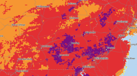
 The National Weather Service warns the week has a good chance to be one of the wettest of the summer thus far, with the potential for showers and storms daily through Thursday.
 -
Join Megan Frank at 9:30 a.m. and 6:30 p.m. every Friday for Insights with LehighValleyNews.com on WLVR. This week, she's joined by politics reporter Tom Shortell and digital managing producer Stephanie Sigafoos.
-
Lehigh County Coroner Dan Buglio said a 93-year-old woman from Upper Macugie Township was pronounced dead in her home Thursday. It's the first heat-related death reported in the area.
-
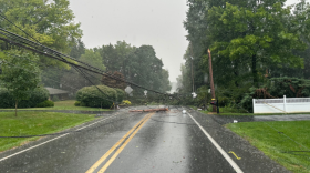
The National Weather Service said a damaging wind threat will increase through the afternoon, and the Lehigh Valley is now under a severe thunderstorm watch for the second straight day.
-
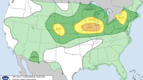
Thousands of Lehigh Valley residents had power cut at the height of the string of storms to batter the area Tuesday. Another round could be on the way Wednesday, according to the Storm Prediction Center.
-
The National Weather Service has extended an excessive heat warning now in effect until at least 6 a.m. Wednesday, with dangerously hot conditions and heat index values up to 106 degrees in the Lehigh Valley.
-
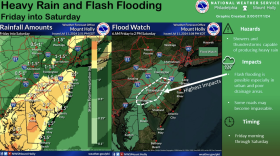
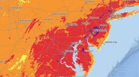
The National Weather Service posted a flood watch starting at 6 a.m. Friday for the Philadelphia region and its suburbs.
-
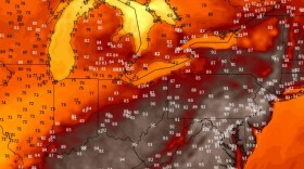
The National Weather Service expanded an excessive heat warning into the Lehigh Valley on Wednesday, calling for dangerously hot conditions with heat index values up to 105 degrees. A severe weather threat will follow.
-
As of Tuesday, the Lehigh Valley was suffocating in its thirteenth day of 90-plus temperatures this summer, well on the way to surpassing the average of 14.42 days in the 90s for records that date back to 1912.
-
Forecasters: Prepare for an active week of weather hazards, including the approach of Beryl remnantsThe Lehigh Valley will face “an active week in terms of weather hazards,” the National Weather Service said early Monday, with the remnants of Beryl expected to impact the area.
-
Possible showers and thunderstorms will provide little relief from the humidity over the next several days, according to the National Weather Service.
-
This Fourth of July in the Lehigh Valley, the fireworks in the sky might come from Mother Nature. There's a storm threat, and some will be capable of producing very heavy rain that could lead to localized flash flooding.