

BETHLEHEM, Pa. — The northern lights bathed the skies during the Perseid meteor shower this week, leaving people in awe on a seasonably cool and refreshing night.
Temperatures dropped into the mid 50s in the Lehigh Valley early Monday, entering what appears to be the home stretch of summer.
A beautiful day followed — with humidity well in check — and we’re expecting more of the same in the coming days, the National Weather Service said on X.
Whether you’re faithful to meteorological summer (June through August) or the astronomical calendar (beginning with the summer solstice and ending with the autumnal equinox), here’s where things stand as we enter the end of summer and the peak of hurricane season.
July look back
July went to the extreme in a lot of places, according to the Northeast Regional Climate Center. That includes extreme temperatures, extreme rainfall and extreme drought.
But while some climate sites saw their hottest, driest or wettest July ever, we didn’t tip the scales too far in either direction in the Lehigh Valley.
The average temperature for the month was 76.9 degrees, or 1.3 degrees above normal. It was our 14th warmest July ever, and 15th warmest month on record overall.
We fell well short in the rain department, with just 3.60 inches of precipitation for the month — just 68% of normal.
Summer slammed with heat
The summer has ranked among our Top 10 warmest on record, with an average temperature of 74.68 degrees entering Tuesday. That ties 2010 for our sixth-warmest summer of all time.
The maximum low temperature — or what the overnights feel like — sat at 77 degrees entering Tuesday.
That means it’s been among our warmest summers in terms of how much it’s not cooling off in the evening and overnight periods.
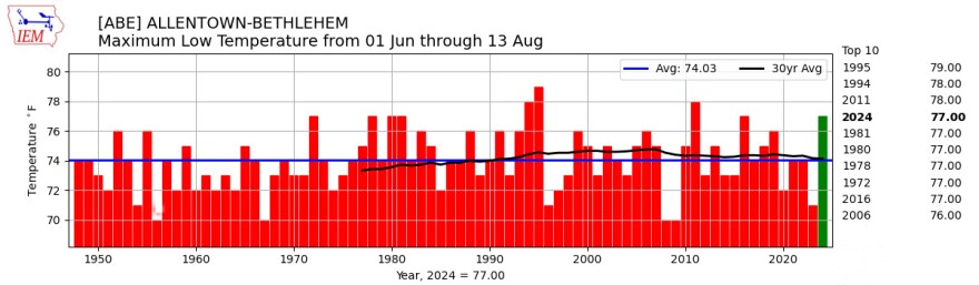
The statistic trails only 1995 (79 degrees), with 1994 and 2011 tied for second at 78 degrees.
Looking ahead, the Climate Prediction Center sees a pattern that will bring near-normal to below-normal temperatures to the region in the weeks ahead.
Hurricane season peak
The same day the remnants of Hurricane Debby blew through the region, experts said atmospheric and oceanic conditions have set the stage for an extremely active Atlantic hurricane season that could rank among the busiest on record.
“NOAA’s update to the hurricane seasonal outlook is an important reminder that the peak of hurricane season is right around the corner, when historically the most significant impacts from hurricanes and tropical storms tend to occur.”NOAA Administrator Rick Spinrad
NOAA updated its 2024 outlook by calling for 17 to 24 named storms, of which eight to 13 are expected to become hurricanes, including four to seven major hurricanes (category 3 or higher).
An average hurricane season typically consists of 14 named storms, including seven hurricanes and three major hurricanes, based on data from 1991 to 2020.
"The hurricane season got off to an early and violent start with Hurricane Beryl, the earliest category-5 Atlantic hurricane on record,” NOAA Administrator Rick Spinrad said.

“NOAA’s update to the hurricane seasonal outlook is an important reminder that the peak of hurricane season is right around the corner, when historically the most significant impacts from hurricanes and tropical storms tend to occur.”
The updated outlook is due to multiple factors, including extremely warm Atlantic sea surface temperatures.
The season already has produced four named storms, with the remnants of Debby producing devastating flooding and multiple tornadoes in the mid-Atlantic and Northeast.
The season peaks from mid-August to late October and runs through Nov. 30.
