Bethlehem Live Weather Camera sponsored by St. Luke's University Health Network
-
 The International Space Station is easily visible from Earth just before dawn or after dusk. It gives off no light of its own, but reflects the Sun off its massive solar panels.
 -
Pennsylvania’s economy will center around agriculture in 2024, according to Gov. Josh Shapiro.
-
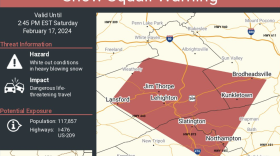
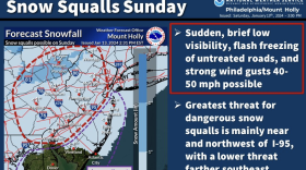
Snow squalls cause dangerous travel conditions and can be blinding for motorists, according to the National Weather Service. The Lehigh Valley is at highest risk from mid-morning into the afternoon.
-
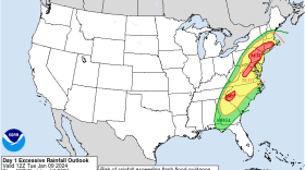
The weather pattern not only remains active – with another flood watch on Friday – it includes a chance of yet another coastal system impacting the mid-Atlantic region early next week.
-
Another soaking rainfall and flood watch are expected for the Lehigh Valley on Friday, forecasters said, with widespread impacts somewhat similar to Tuesday’s storm. Then, we take a wintry turn next week.
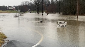
-
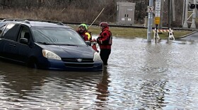
Ignoring repeated warnings, some Lehigh Valley motorists find themselves stranded after driving through deep roadway water.
-
Over two inches of rain fell at Lehigh Valley International Airport, setting another daily record on Tuesday, but winds were less than feared.
-
Another powerful winter storm is set to hit the region, bringing concerns of widespread flooding and high winds Tuesday into Wednesday.
-
A severe rainstorm is expected to cause flooding that may impact roadways throughout the Lehigh Valley.
-
A Muhlenberg College professor has launched a campaign this month to inform residents about the health risks of radon, as well as improve access to testing and mitigation. The Lehigh Valley is home to the highest radon levels ever recorded in Pennsylvania.


-
Brad Klein reviews the week’s astronomical highlights with Bethlehem’s "Backyard Astronomy Guy," Marty McGuire.
-
The Lehigh Valley Planning Commission last week released a draft of its Priority Climate Action Plan, a document almost a year in the making aimed at tamping down the region’s carbon emissions and mitigating the effects of climate change.
-
The National Weather Service issued the warning Saturday afternoon for parts of Lehigh and Northampton counties, extending into Carbon County.
-
Take a look at stories that ran throughout the week of which we are most proud, had a profound impact on readers or that you might want to look at again.
-
Five farms, three in Lehigh County and two in Northampton County, were the latest to be included in the commonwealth’s Farmland Preservation Program, along with more than a dozen others across the state.
-
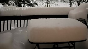
Some areas reported almost 14 inches of snow, with flakes the size of cotton balls. Other areas got just a few inches. Said a National Weather Service meteorologist: 'I completely understand the shock factor.'
-
The Lehigh Valley is under a winter weather advisory in effect from 10 p.m. Friday to 10 a.m. Saturday, with a chance the snowfall that could overperform in parts of the region.
-
WLVR's Megan Frank talks with journalists Molly Bilinski and Phil Gianficaro.
-
Presidents Day weekend is approaching, and historically the period has been prime time for big storms. That won't be the case Friday, but a few inches of snow are possible in the Lehigh Valley.
-
A Lehigh Valley resident was recognized as a “Volunteer of the Year” for 2023 by Keep Pennsylvania Beautiful, a statewide nonprofit that focuses on litter cleanups and community improvements.
-
Less than 24 hours removed from the Lehigh Valley’s heaviest snowfall in three years, forecasters have a word of advice to offer: don’t put the shovel away just yet.
-
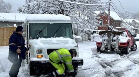
Tuesday's fast-moving storm swept quickly through the Lehigh Valley but packed a wallop, bringing nearly a foot of snow to several spots.