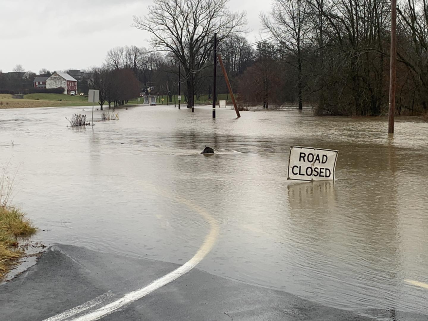
UPDATE: Storm aftermath - Record-setting rain closes schools, floods streets, prompts several water rescues
BETHLEHEM, Pa. — Exercise caution.
That’s the advice from local and state emergency management agencies in anticipation of the intense wind and rainstorm expected to cause severe flooding of roadways, rivers and creeks throughout the Lehigh Valley from Tuesday into Wednesday.
A rainfall total of 2-3 inches is expected, according to the National Weather Service. A flood warning is in effect until 12:15 a.m. Wednesday.
Exacerbating the prospect of flooding is the amount of snow remaining from last weekend’s storm.
The Lehigh Valley got 5-9 inches. Fast-rising temperatures combined with heavy rain and snow melt will contribute to flooding, causing roadways to become flooded and virtually impassable and dangerous to drive through, officials said.
"We're setting up the barricades near the typically flood prone areas so they're already in place if it looks like the road will be flooded."Mark Shahda, director of public works, Allentown
A wind advisory also has been issued, with southeast winds at 25-35 mph and gusts up to 55 mph that may lead to downed trees and power lines and outages.
'Working around the clock'
Allentown Public Works Director Mark Shahda said work crews are delivering barricades along the usual roads that become flooded during rainstorms.
"We're setting up the barricades near the typically flood-prone areas so they're already in place if it looks like the road will be flooded," Shahda said.
"Crews will be working around the clock to monitor the road conditions, so we'll be ready."
The Lehigh River is expected to reach minor flood stage in Walnutport and water will be near or slightly above the top of the banks in Bethlehem, officials said.
“There are parts of Lower Macungie and Upper Saucon townships that often flood. We see the streams rise up pretty quickly. So we always kind of watch that, and keep an eye on that.”Lehigh County Emergency Management Director Tanya Hook
Prior to the most recent snowstorm, Lehigh County Emergency Management Director Tanya Hook said she was concerned about flooding of low-lying areas around rivers.
“There are parts of Lower Macungie and Upper Saucon townships that often flood,” Hook said. “We see the streams rise up pretty quickly. So we always kind of watch that, and keep an eye on that.”
According to a Facebook post, 120 barriers were put up in the city of Allentown.
The following are parts of Lehigh and Northampton counties that have experienced flooding during previous heavy rainstorms:
Allentown:
- Hamilton Boulevard from Ott Street to Hamilton Street bypass
- South St. Elmo Street from Martin Luther King Jr. Drive to Union Street
- Walnut Street from Lafayette Street to the Bridge on St. Elmo
- Auburn Street from S. 5th Street to Basin Street
- Mack Boulevard from Dixon Street to Juniata Street
- Dixon Street from Mack Boulevard to S. 7th Street
- Public Road from S. 5th Street to S. 8th Street
- Sumner Avenue from North Meadow Street to Ridge Avenue
- S. 12th Street at Vultee Street to Downyflake Road
Macungie area:
- Spring Creek Road
- Sauerkraut Lane between Wild Cherry and Macungie roads
- Wild Cherry Lane between Sauerkraut Lane and Lower Macungie Road
- Lehigh Street, Macungie
- Cetronia Road -Trexlertown Road to West Grange Road
- Willow Lane, Lower Macungie
Parks:
- Jordan Creek (Jordan Park)
- Lehigh Parkway
Salisbury Township:
- Lehigh Street at 33rd St. Southwest (in front of South Mall)
Bethlehem/Bethlehem Township:
- Route 378 Southbound
- Industrial Drive at Avenue B
- Conestoga Street
- Fire Lane
- Mauch Chunk Road
- Easton Avenue and Santee Road
- Easton Avenue and Willow Park Road
- Plus, the Monocacy Creek likely will inundate the historic area downtown
Catasauqua:
- Hokendauqua Park / Lehigh Street
Easton area / Forks:
- Bushkill Park / Bushkill Creek
- Lehigh Drive along the Lehigh River and Delaware Drive (Rt. 611)
- South Side by Line Street and Centre Street
Slate Belt:
- Bangor Road
- Messinger and Lower South Main streets in Bangor
Upper /Lower Saucon townships:
- Lanark Road in the area of West Saucon Valley Road in Upper Saucon
- Springtown Hill Road between Orchard and Lower Saucon Roads
Residents can monitor river and stream gauges via the National Weather Service Mid-Atlantic River Forecast Center at www.weather.gov/marfc or by downloading the FloodWatch app on a smartphone.
To view or report Met-Ed power outages, go to https://firstenergycorp.com/outages_help.html.
To view or report PPL power outages, go to https://www.pplelectric.com/site/Outages-and-Issues
Non-emergency phone numbers:
- Lehigh County, 610-437-5252.
- Northampton County, 610-759-2200.
Pennsylvania Emergency Management Agency Director Randy Padfield reminds residents they can register for free emergency and weather alerts at AlertPA.
Roadway conditions and closures throughout the Lehigh Valley can be monitored at https://511pa.com/