Bethlehem Live Weather Camera sponsored by St. Luke's University Health Network
-
 Easton is looking for a new conservation management apprentice, a position which will entail planting and maintaining urban trees throughout the city.
 -
Several districts announced they would be closed Tuesday because of the weather forecast, which calls for 4 to 6 inches of snow in the Lehigh Valley.
-
The Lehigh Valley is under a winter weather advisory, and forecasters say every snowflake that falls will stick easily as the coldest air of the season moves in.
-
The International Space Station is easily visible from Earth just before dawn or after dusk. It gives off no light of its own, but reflects the Sun off its massive solar panels.
-
Pennsylvania’s economy will center around agriculture in 2024, according to Gov. Josh Shapiro.
-
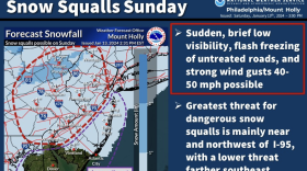
Snow squalls cause dangerous travel conditions and can be blinding for motorists, according to the National Weather Service. The Lehigh Valley is at highest risk from mid-morning into the afternoon.
-
The weather pattern not only remains active – with another flood watch on Friday – it includes a chance of yet another coastal system impacting the mid-Atlantic region early next week.
-
Another soaking rainfall and flood watch are expected for the Lehigh Valley on Friday, forecasters said, with widespread impacts somewhat similar to Tuesday’s storm. Then, we take a wintry turn next week.
-
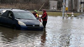
Ignoring repeated warnings, some Lehigh Valley motorists find themselves stranded after driving through deep roadway water.
-
Over two inches of rain fell at Lehigh Valley International Airport, setting another daily record on Tuesday, but winds were less than feared.


-
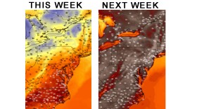
Heat and humidity will build for the afternoon, heightening a severe weather risk for the Lehigh Valley on Friday, forecasters say. It comes before a heat wave arrives in the region next week.
-
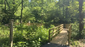
For the first time in more than three decades, and at a cost of nearly $500,000, the Boardwalk at the Dorothy Rider Pool Wildlife Sanctuary.has been completely restored and made compliant with the Americans with Disabilities Act.
-
Heat index outlooks — projecting what it feels like outside with the heat and humidity combined — push feels-like temperatures near triple digits between June 17-21 and top 100 degrees in the Lehigh Valley between June 19-25.
-
More than two dozen state legislators, including one from the Lehigh Valley, have co-sponsored HB2238, which would eliminate the use of per- and poly-fluoroalkyl substances, or PFAS, in household products.
-
Allentown Environmental Advisory Council members on Monday night voted unanimously to submit comments to city officials on a proposed overhaul of zoning regulations, including eight recommendations.
-
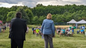
Northampton County's Parks and Recreation Division and the Lehigh Valley Greenways Conservation Landscape celebrated big anniversaries Monday during the Greenways Jamboree Monday at Wayne Grube Memorial Park.
-
State officials are holding a virtual town hall meeting Wednesday for residents to share their feedback on the Bureau of Forestry’s newest strategic plan. Here's how to participate.
-
The weather pattern this week will be a tale of two halves, with sunny skies and comfortable temperatures before things heat up in a big way. The region's first heat wave could also be looming, forecasters warn.
-
In this week's Watching the Skies, Brad Klein and Marty McGuire talk about how China landed a spacecraft on the far side of Earth's moon on June 1 to gather rock and soil samples.
-
The release is the first of a long list of fun summer activities planned for young readers at the library.
-
Officials gathered at the Lehigh Valley Zoo Thursday evening for a ribbon cutting to celebrate the opening of Rothrock Red Panda Peak. It's the first time the zoo has had red pandas in residence.
-
The complaint alleges Sunshine Act violations from the township supervisors and legal filings from the township solicitor with no official approval beforehand.