Bethlehem Live Weather Camera sponsored by St. Luke's University Health Network
-
 Northern flying squirrels are endangered, and the Pa. Game Commission works to improve their habitat. A group went searching for the species in the Poconos.
 -
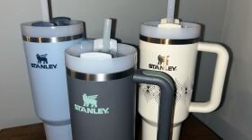
Stanley cups have skyrocketed in popularity, following other trends in reusable drinkware. But, fads like these can encourage overconsumption, experts said.
-
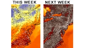
Right now, the overall pattern isn’t very conducive to significant snowfall for the Lehigh Valley and the Mid-Atlantic next week. Here's what will make or break the event for snow lovers.
-
The state agency that promotes hunting in Pennsylvania has hired a lobbying firm run by a former top lawmaker using tens of thousands of dollars in public funds.
-
The South Whitehall Board of Commissioners on Wednesday waived the land development review requirement for a Tesla charging station at the Wawa at 408 S Cedar Crest Blvd., near Dorney Park.
-
Temperatures in the Lehigh Valley have averaged 5.4 degrees above normal to begin February — but experts say our springlike pattern will flip in a big way next week.
-
This weekend is the 27th annual Lehigh Gap Area Feeder Watch. Officials are calling for volunteers.
-
Easton's Environmental Advisory Council is looking to the future to address the potential needs for residents in the wake of global warming, even if net zero emissions are met.
-
Head Over Hooves Farm will run on a donation model through the month of February to encourage more visitors. The owners of the farm say the animals thrive on the socialization and enrichment the visits bring.
-
Learn more about Orion in this, the second of five segments about the constellation.


-
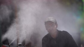
Heat and humidity will build for the afternoon, heightening a severe weather risk for the Lehigh Valley on Friday, forecasters say. It comes before a heat wave arrives in the region next week.
-
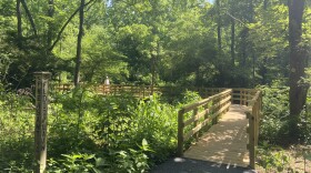
For the first time in more than three decades, and at a cost of nearly $500,000, the Boardwalk at the Dorothy Rider Pool Wildlife Sanctuary.has been completely restored and made compliant with the Americans with Disabilities Act.
-
Heat index outlooks — projecting what it feels like outside with the heat and humidity combined — push feels-like temperatures near triple digits between June 17-21 and top 100 degrees in the Lehigh Valley between June 19-25.
-
More than two dozen state legislators, including one from the Lehigh Valley, have co-sponsored HB2238, which would eliminate the use of per- and poly-fluoroalkyl substances, or PFAS, in household products.
-
Allentown Environmental Advisory Council members on Monday night voted unanimously to submit comments to city officials on a proposed overhaul of zoning regulations, including eight recommendations.
-
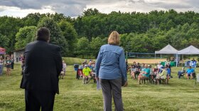
Northampton County's Parks and Recreation Division and the Lehigh Valley Greenways Conservation Landscape celebrated big anniversaries Monday during the Greenways Jamboree Monday at Wayne Grube Memorial Park.
-
State officials are holding a virtual town hall meeting Wednesday for residents to share their feedback on the Bureau of Forestry’s newest strategic plan. Here's how to participate.
-
The weather pattern this week will be a tale of two halves, with sunny skies and comfortable temperatures before things heat up in a big way. The region's first heat wave could also be looming, forecasters warn.
-
In this week's Watching the Skies, Brad Klein and Marty McGuire talk about how China landed a spacecraft on the far side of Earth's moon on June 1 to gather rock and soil samples.
-
The release is the first of a long list of fun summer activities planned for young readers at the library.
-
Officials gathered at the Lehigh Valley Zoo Thursday evening for a ribbon cutting to celebrate the opening of Rothrock Red Panda Peak. It's the first time the zoo has had red pandas in residence.
-
The complaint alleges Sunshine Act violations from the township supervisors and legal filings from the township solicitor with no official approval beforehand.