

BETHLEHEM, Pa. — A potent low-pressure system will draw warm and moist air into the region before an intense cold front brings a sudden drop in temperatures later this week, forecasters say.
It’s part of what will be a wild and windy few days for the Lehigh Valley and the rest of the Mid-Atlantic region.
“We will have showers moving in during the afternoon hours" Tuesday, EPAWA meteorologist Bobby Martrich said in his latest video update.
EPAWA's 2/27 and week ahead outlook, covering:
— Bobby Martrich | EPAWA (@epawawx) February 27, 2024
■ Timing of the showers today through overnight
■ Cold front Wednesday evening with rain and wind
■ Colder late week, but milder moves back in after https://t.co/oaDNJVdw4i
“You’re going to have some showers move in initially, then you’re going to get a break.
“This is going to be like a three-peat thing where you have one wave move through, then you get a break. Then you get another wave moving through, another break, and then the main event, which is the cold front coming through.”
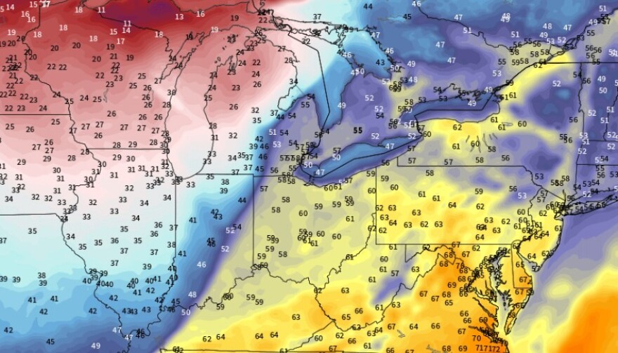
More like early summer
Increasing southerly winds Tuesday will really help to bump temperatures, letting most areas rise into the 60s, the National Weather Service said in its latest forecast discussion.
Winds are expected to increase to 10 to 20 mph, with some gusts as high as 25 to 30 mph by afternoon.
It’s also expected to be a very mild night, and Wednesday could dawn with record warm lows in jeopardy across the region.
In a number of locations that will challenge records, including Allentown, the predicted low temperature for the day will be warmer than the average afternoon high.
Allentown’s highest daily low for Feb. 28 is 44 degrees, with a low temperature of 54 degrees expected.
Wednesday’s high temperature for the day is forecast to be 60 degrees.
‘Wind will likely be greatest impact’
The focus of the short-term forecast will be the strong cold front moving through Wednesday, with rain rates increasing as it draws near.
The weather service said periods of heavy rain are likely, with Carbon and Monroe counties included in a marginal risk for excessive rainfall.
Rain could also turn to snow in the northern tier.
“Though there will be potent cold air advection behind the front, pure snow is not expected,” the weather service said.
“Some wet snowflakes may be observed in some locations as precipitation ceases, however, this will not amount to much. The only areas which may see some accumulating snow on the backside of the front is the Poconos, around 1 inch or less.”
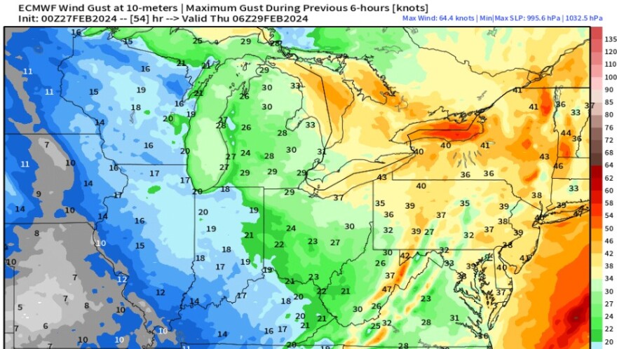
Overall, wind will likely have the greatest impact with this event and wind advisories are likely to be issued during the next forecast cycles, the weather service said.
Following the passage of the front, highs in the 60s will be cut down more than 20 degrees.
Thursday's high temperature in Allentown is expected to be 39 degrees.
