BETHLEHEM, Pa. — A wind advisory expired early Thursday, but thousands of residents in the Lehigh Valley were without power after high winds pummeled the region overnight.
The strongest gust registered at the airport was 43 mph around 8:20 p.m. Wednesday.
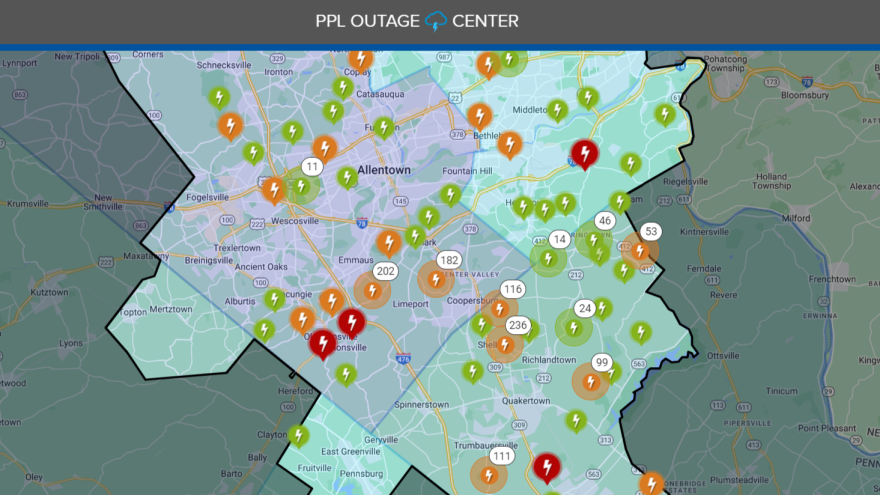
PPL’s outage map showed more than 3,000 in the dark in Lehigh County around 5 a.m. Thursday, along with 900 outages in Northampton County.
First Energy Corp., the parent company of Met-Ed, reported 46 outages in Lehigh County, but more than 1,100 in Northampton.
Now, restoration work begins as winds abate. But the National Weather Service said it will remain quite breezy, with winds gusting 25 to 35 mph to continue through most the day Thursday.
Temperatures also plummeted behind the cold front that barreled through the region, with temperatures in the 20s and wind chills in the teens.
Here is a look at today's forecast. Though high pressure will build into the region from the west today, snow showers from the northwest may enter our region. A few snow squalls for our northwestern most areas this morning cannot be ruled out. #NJwx #PAwx #DEwx #MDwx pic.twitter.com/IvAgdiZre5
— NWS Mount Holly (@NWS_MountHolly) February 29, 2024
Snow becomes a complicating factor
As utilities scramble to get power back, the weather service warned of snow showers over northern Pennsylvania and upstate NY that will make their way into the southern Poconos and through the Lehigh Valley.
"The highest threat for snow squalls should stay just off to our north and west, but can't rule out a couple of squalls could make their way into the I-78 and especially the I-80 corridor over Northeast PA in the 5 a.m. to 8 a.m. time frame," the forecast discussion said.
"Winds will still be fairly strong and gusty at this time meaning any heavier snow showers could produce a rapid drop in visibility due to falling and blowing snow."
PPL said Wednesday it had hundreds of workers “ready to work around the clock to help get customers back online as safely and efficiently as we can," but snow could be a complicating factor.
Unsettled pattern ahead
The weather service said the short-term will continue to be unsettled, with a low pressure system forecast to develop just offshore Friday. It's expected to track northeast Saturday and Saturday night and stall, bringing light to moderate rain across the region Friday night and into the weekend.
Precipitation chances will decrease with time Saturday and Saturday night, the weather service said, but most of the region could see rainfall amounts of at least a quarter inch, with some areas expecting a half-inch or more.
Models also suggest that cold air damming will be in place during the onset of precipitation for northern areas, and some spots could see frozen precipitation as a result.
"At best, the Poconos could see a trace to an inch of snow before rain washes any small accumulation away," the NWS forecast discussion said.