Bethlehem Live Weather Camera sponsored by St. Luke's University Health Network
-
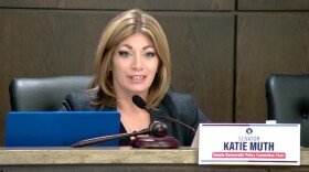
 State lawmakers on Monday held a committee hearing titled “Minimizing Risk & Harm: Preparing for Pennsylvania’s Hydrogen Future.” It comes almost two months after President Joe Biden announced seven regional clean hydrogen hub projects, including two in Pennsylvania.
 -
Your name can travel to space on the Europa Clipper Spacecraft. NASA’s ‘Message in a Bottle’ program is open through the end of December.
-
The state Department of Environmental Protection's Energy Programs Office will host five public engagement sessions in December, four in-person and one virtual, as officials work to create a priority climate action plan to address the negative effects of climate change.
-
Take a look at stories that ran throughout the week of which we are most proud, had a profound impact on readers or that you might want to look at again.
-
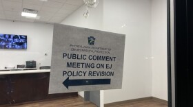
Residents from the Lehigh Valley and beyond on Thursday attended the state Department of Environmental Protection’s last public comment meeting on the commonwealth’s interim environmental justice policy. The majority said the policy doesn’t go far enough.
-
Blue Mountain Resort took full advantage of a recent cold snap across the region to fire up the snow guns — and schedule Opening Day on Friday.
-
While plans for the site include homes, offices, restaurants and other facilities at the 200-acre East Side property, regulations call for at least 35%, or about 70 acres, to be preserved as open space for outdoor recreation.
-
Wildlands Conservancy’s first fall photography contest is underway, with entries due just before midnight Thursday. Officials said the contest aims to encourage residents to explore the outdoors, as well as share their interest in nature with others in the community.
-
The Lehigh County Authority used municipal meetings to highlight what upgrades were currently planned to Lehigh County's sewer system, and what might be needed form the local governments
-
The coldest air of the season thus far is arriving in the Lehigh Valley, with forecasters touting conditions favorable for snow showers and squalls this afternoon.


-
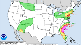
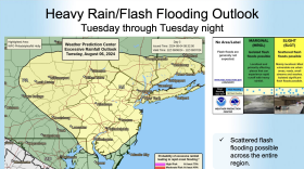
The Lehigh Valley will begin to see impacts from Tropical Cyclone Debby on Tuesday, forecasters warn, calling expected rainfall a ‘predecessor’ event as the storm begins to crawl up the coast.
-
This week, Watching the Skies gives an update on the International Space Station, which is currently hosting two ‘extra’ American astronauts.
-
Saturday’s weather plagued Musikfest and there’s a chance more of the same is in store Sunday for the Lehigh Valley region. After a sunny Monday, heavy rain is in the forecast Tuesday.
-
Following a severe thunderstorm yesterday, the Lehigh Valley should brace for more intense weather
-
Downpours and thunderstorms are expected to ramp up across the region heading into the weekend. Here's what to expect if you have outdoor plans, especially if you're heading to Musikfest in Bethlehem.
-
Over the past few days, Lehigh Valley residents have complained of bad smells wafting through Bethlehem and surrounding areas. Residents have described the most recent heavy odor as a rotting smell.
-
Another wave of heat is forecast for the Lehigh Valley and a large swath of the region in the coming days, with heat index values up to 100 degrees expected, the National Weather Service said.
-
ArtsQuest has a plan to keep people safe and hydrated as temperatures rise later this week. But once again, dodging storms on a couple of nights could be the weather headline of Musikfest 2024, says EPAWA meteorologist Bobby Martrich.
-
One of the best chances to ‘catch a falling star’ is the Perseid meteor shower. And the evening of Aug. 12 and early morning of Aug. 13 should be the peak night for this annual event.
-
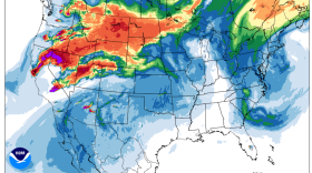
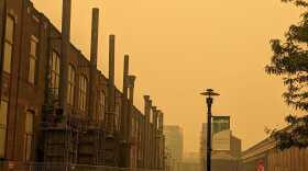
“Noticing a haziness to the sky today? That is due to the smoke spreading into the region aloft from the wildfires in western North America,” the National Weather Service said on X.
-
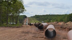
PennFuture and the Delaware Riverkeeper Network earlier this month realized a win in their case against the Transcontinental Gas Pipe Line Company, or Transco, and the state Department of Environmental Protection.
-
North America’s smallest falcon is threatened due to habitat loss, as well as other factors. A conservation project at Waste Management's Grant Central Landfill near Pen Argyl seeks to boost conservation.