-
 After days of sweltering heat, the Lehigh Valley can finally expect a break as a cold front brings modest relief and cooler temperatures, forecasters say.
 -
On Tuesday afternoon, Lehigh Valley International Airport recorded temperatures that tied the record heat set in Allentown over a century ago on June 24.
-
No climate site in the region reached 100 degrees on Monday, but the suffocating heat and humidity was still record-setting across the Mid-Atlantic region.
-
PJM Interconnection, the regional grid operator headquartered in Valley Forge, issued a maximum generation alert and load management alert for Monday.
-
Allentown hasn't had a 100-degree day since July 2011. The forecast high on Tuesday is now 100 degrees.
-
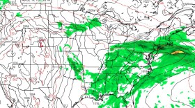
With temperatures in the low 90s and heat indices spikes toward 100, showers and thunderstorms are expected in the area by early evening.
-
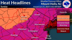
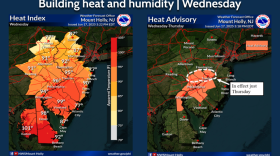
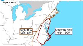
Severe storms, dangerous heat and rising humidity are in the forecast for the Lehigh Valley. Here's what to expect this week and into next.
-
As the summer solstice arrives this week, the long-range outlook depicts a pattern shift that will go from seasonal to sizzler in a hurry, forecasters warn.
-
The Lehigh Valley has endured nearly non-stop weekend rain since April, marking one of the region’s wettest springs. Despite high rainfall totals, flooding hasn't been a concern.
-
A stalled front could bring rain, clouds, and cooler temperatures to the Lehigh Valley this weekend, impacting major events like Allentown’s Blues, Brews & Barbeque and Bethlehem’s Juneteenth celebration.

Your Local News | Allentown, Bethlehem & Easton
Play Live Radio
Next Up:
0:00
0:00
Available On Air Stations