
BETHLEHEM, Pa. — The Lehigh Valley hasn’t reached 90 degrees yet this year, but experts suggest it won’t be long before that summer benchmark is met — and then some.
The long-range outlook depicts a pattern shift that will go from seasonal to sizzler in a hurry, forecasters warn.
Models are signaling an intense ridge of high pressure setting in by next weekend across the rain-soaked Northeast, opening the door for a potential heat wave.
But that first 90-degree day — viewed as a true summer benchmark — might come even earlier.
Dreary conditions to strong storms
After dreary conditions, showery weather and below-average temperatures to kick off the week, Mother Nature is expected to flip the script in a big way.
Highs in the 60s on Monday and low 70s Tuesday will push to the mid-80s by Wednesday.
And then?
“The pattern finally looks to change for the end of this week and into next weekend,” the National Weather Service said in its latest forecast discussion.
“Bermuda high pressure sets up offshore and strong warm air advection will result in a hot and increasingly humid air mass into the region on Thursday."
Highs are expected to be in the low 90s across parts of the region — including the upper 80s to right around 90 degrees in the Lehigh Valley.
Surface dew points also are expected to be in the low 70s, pushing max heat index values to the mid- to upper-90s north to south.
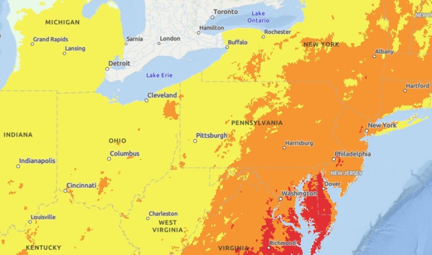
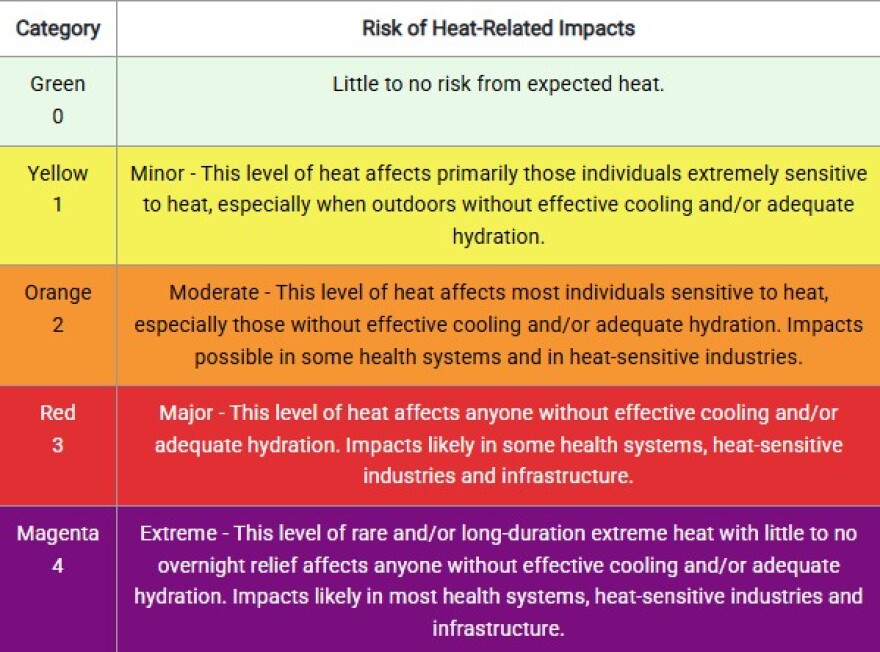
The NWS HeatRisk categories are forecast to be level 2 or level 3 (north to south though the Philly metro area), indicating that the heat likely will affect anyone without effective cooling or adequate hydration.
Storms associated with a strong cold front passing through the region Thursday and Thursday night may be strong to severe, the discussion said.
The Storm Prediction Center has a 15% risk for severe weather across portions of the Northeast and Mid-Atlantic, with the primary threat being damaging wind gusts.
Here comes the heat
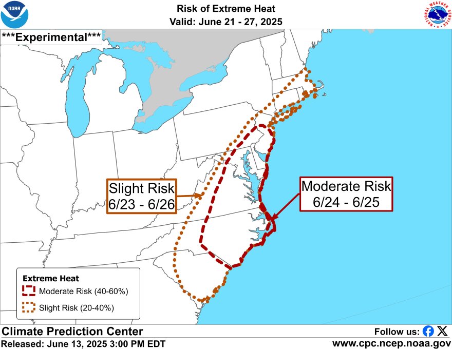
The Climate Prediction Center is forecasting a strong heat wave likely for much of the Mid-Atlantic during the first week of summer, as the solstice officially arrives Friday.
EPAWA meteorologist Bobby Martrich said temperatures will get slightly above average on Saturday and approaching 90 degrees again Sunday.
“It’ll be the first day, we think, of a possible heat wave,” Martrich said in his latest video update.
“A heat wave is defined as three or more consecutive days of 90 degrees or above, and we could have that in the Sunday, Monday, Tuesday and maybe even Wednesday (6/22 to 6/25) time frame,” Martrich said.
He said temperatures could be in the low- to mid-90s or higher, with heat index values beyond that.
“It’s still very soupy in this time frame,” he said. “You’ve got a southwesterly wind flow in this case, so it’s going to be hot and humid.”
Martrich said it would be an abbreviated heat wave, likely ending next Wednesday.
“This is not going to be an extended thing that’s going to last for weeks," he said. "This is just for a 3-to-4 day period.”
