Bethlehem Live Weather Camera sponsored by St. Luke's University Health Network
-
 The region saw a temperature swing of nearly 50 degrees in less than 24 hours
 -
Plans are in the works for flower CSAs — Community Supported Agriculture — subscriptions that will bring joy and color to 2023. Here's how you can sign up, and bring the fragrant anticipation of the blooms to come.
-
The appearance of a massive, rotating ice circle caught the attention of a city resident who captured drone video near Groundhog Lock along the Delaware Canal in Raubsville, south of Easton.
-
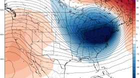
The extreme weather stretched from the Great Lakes near Canada to the Rio Grande along the border with Mexico. About 60% of the U.S. population faced some sort of winter weather advisory or warning, and temperatures plummeted drastically below normal from east of the Rocky Mountains to the Appalachians.
-
The National Weather Service says temperatures won't get out of the 20s again Monday. But the Lehigh Valley will see significant changes by the middle of the week.
-
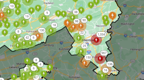
Thousands in the Lehigh Valley and nearby remain without power as PPL sets up resource centers for those impacted
-
Will it snow next week? How about the week after? Weather enthusiasts are constantly hanging on "one model run in a sea of model runs," making the job of the local meteorologist even more difficult in trying to convey the forecast.
-
The region could see wind chills as low as -15 degrees overnight as temperatures rapidly fall. The expected high winds could lead to power outages due to falling branches. PPL says it has 2,000 workers ready to respond.
-
The vote came after a raucous and at times chaotic council meeting and an hours-long public hearing on the proposal. Residents who showed up to speak against it filled Town Hall.
-
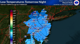
The National Weather Service said the winter storm targeting the Lehigh Valley contains "an air mass the likes of which we haven’t seen for several years."


-
Schools are closing early and a large swath of the region is under a flood warning until at least 3:15 p.m. as the storm system that inundated the area overnight moves north.
-
The winter, or December, solstice takes place this year between sundown on Dec. 21 and sunrise Dec. 22
-
The Lehigh Valley Planning Commission at 11 a.m. on Wednesday is holding a meeting at its Allentown office to brainstorm and prioritize ways to decarbonize transportation across the region. Decarbonization is the process of reducing or eliminating carbon dioxide emissions.
-
Many spots could receive 2 to 3 inches of rain, forecasters warn, with areas of flooding possible Sunday night as another coastal storm targets the region.
-
Amid the joy and festivities, environmental advocates are urging residents to keep sustainability in mind during what can be a time of year when trash and waste spikes.
-
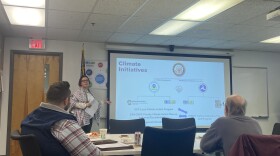
State environmental officials on Thursday evening hosted the last of five public engagement sessions, as they work to create a Priority Climate Action Plan, or PCAP, aiming to reduce greenhouse gas emission statewide and mitigate further effects of climate change.
-
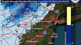
Forecasters say another impactful storm is expected to move up the coast, bringing heavy rain and gusty winds to the region Sunday into Monday.
-
The new official map marks recently acquired land, while setting priorities for future desired open space.
-
A Tuesday evening webinar cosponsored by the Bethlehem Area Public Library and Bethlehem Food Co-Op focused on how residents can meaningfully participate in the city’s efforts to fight climate change.
-
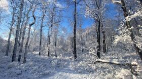
The Lehigh Valley remains devoid of accumulating snow events so far in December —and it looks like that pattern will continue straight through the holiday season.
-
Brad Klein reviews the week’s astronomical highlights with Bethlehem’s 'Backyard Astronomy Guy," Marty McGuire.
-
Sunday's rain could transition to snow as the storm system departs the region Monday morning, with the potential to affect the morning commute, according to the National Weather Service.