Bethlehem Live Weather Camera sponsored by St. Luke's University Health Network
-
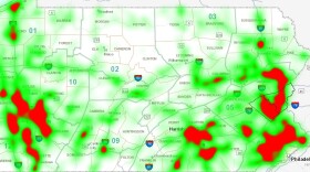
 A heat map generated from PennDOT crash statistics shows a high rate of collisions involving deer and vehicles — the Lehigh Valley included. Pennsylvania also ranked No. 3 overall for the likelihood of having an animal-vehicle collision.
 -
Several Lehigh Valley residents reported witnessing a string of lights in the sky in the Allentown and Bethlehem areas on Saturday night, Sept. 16.
-
High pressure originating from the Great Lakes is shifting offshore on Sunday, paving the way for an approaching cold front and unsettled conditions.
-
The fellowship focuses on bolstering students who show interest and promise in leadership and social impact. Of the more than 44,000 applications submitted, only 4,000 were accepted.
-
Take a look at stories that ran throughout the week of which we are most proud, had a profound impact on readers or that you might want to look at again.
-
The mud-colored salamander–also known as a snot otter, mud devil, and Allegheny alligator–can grow to be two feet long, and can live up to 30 years.
-
This year's Bake Oven Knob Autumn Hawk Watch has so far recorded more than 1,000 migrating birds of prey, not including the dozens logged Thursday morning.
-
How much snow is coming this winter? Model ensembles and long-range outlooks are starting to yield some clues.
-
Officials at Jacobsburg Environmental Education Center on Wednesday held their annual "Monarch Madness" tagging event. Four male and two female monarchs were tagged.
-
Just days away from the official start of fall, forecasters say the Lehigh Valley will see a long stretch of dry weather and seasonal temperatures ahead.


-
Schools are closing early and a large swath of the region is under a flood warning until at least 3:15 p.m. as the storm system that inundated the area overnight moves north.
-
The winter, or December, solstice takes place this year between sundown on Dec. 21 and sunrise Dec. 22
-
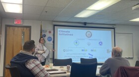
The Lehigh Valley Planning Commission at 11 a.m. on Wednesday is holding a meeting at its Allentown office to brainstorm and prioritize ways to decarbonize transportation across the region. Decarbonization is the process of reducing or eliminating carbon dioxide emissions.
-
Many spots could receive 2 to 3 inches of rain, forecasters warn, with areas of flooding possible Sunday night as another coastal storm targets the region.
-
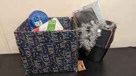
Amid the joy and festivities, environmental advocates are urging residents to keep sustainability in mind during what can be a time of year when trash and waste spikes.
-
State environmental officials on Thursday evening hosted the last of five public engagement sessions, as they work to create a Priority Climate Action Plan, or PCAP, aiming to reduce greenhouse gas emission statewide and mitigate further effects of climate change.
-
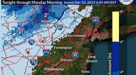
Forecasters say another impactful storm is expected to move up the coast, bringing heavy rain and gusty winds to the region Sunday into Monday.
-
The new official map marks recently acquired land, while setting priorities for future desired open space.
-
A Tuesday evening webinar cosponsored by the Bethlehem Area Public Library and Bethlehem Food Co-Op focused on how residents can meaningfully participate in the city’s efforts to fight climate change.
-
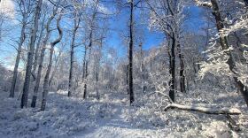
The Lehigh Valley remains devoid of accumulating snow events so far in December —and it looks like that pattern will continue straight through the holiday season.
-
Brad Klein reviews the week’s astronomical highlights with Bethlehem’s 'Backyard Astronomy Guy," Marty McGuire.
-
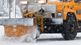
Sunday's rain could transition to snow as the storm system departs the region Monday morning, with the potential to affect the morning commute, according to the National Weather Service.