Bethlehem Live Weather Camera sponsored by St. Luke's University Health Network
-
 The region saw a temperature swing of nearly 50 degrees in less than 24 hours
 -
Plans are in the works for flower CSAs — Community Supported Agriculture — subscriptions that will bring joy and color to 2023. Here's how you can sign up, and bring the fragrant anticipation of the blooms to come.
-
The appearance of a massive, rotating ice circle caught the attention of a city resident who captured drone video near Groundhog Lock along the Delaware Canal in Raubsville, south of Easton.
-
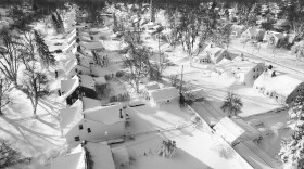
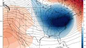
The extreme weather stretched from the Great Lakes near Canada to the Rio Grande along the border with Mexico. About 60% of the U.S. population faced some sort of winter weather advisory or warning, and temperatures plummeted drastically below normal from east of the Rocky Mountains to the Appalachians.
-
The National Weather Service says temperatures won't get out of the 20s again Monday. But the Lehigh Valley will see significant changes by the middle of the week.
-
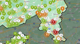
Thousands in the Lehigh Valley and nearby remain without power as PPL sets up resource centers for those impacted
-
Will it snow next week? How about the week after? Weather enthusiasts are constantly hanging on "one model run in a sea of model runs," making the job of the local meteorologist even more difficult in trying to convey the forecast.
-
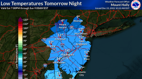
The region could see wind chills as low as -15 degrees overnight as temperatures rapidly fall. The expected high winds could lead to power outages due to falling branches. PPL says it has 2,000 workers ready to respond.
-
The vote came after a raucous and at times chaotic council meeting and an hours-long public hearing on the proposal. Residents who showed up to speak against it filled Town Hall.
-
The National Weather Service said the winter storm targeting the Lehigh Valley contains "an air mass the likes of which we haven’t seen for several years."


-
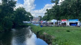
Musikfest attracts tens of thousands of people to the city each day during its 10-day run. Officials said they’re continuously working to lessen the event’s impact on the environment.
-
Take a look at stories that ran throughout the week of which we are most proud, had a profound impact on readers or that you might want to look at again.
-
Following morning sunshine, thunderstorms are in the forecast. But will the Lehigh Valley see severe weather on Saturday?
-
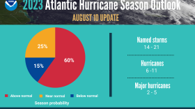
Record-warm ocean temperatures are likely to fuel the peak of hurricane season, scientists at the National Oceanic and Atmospheric Administration said Thursday.
-
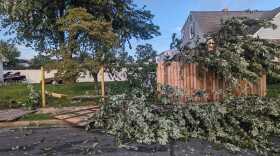
Who ya gonna call?: Residents hit by Monday's tornado learn the do's and don't's of road to recoveryFor those who lost power in their homes due to the tornado that raced through Allentown on Monday, the first thought would be to call PPL. Think again.
-
It’s the peak of the annual Perseid meteor shower and WLVR’s Brad Klein speaks with a local amateur astronomer about how best to see meteors in the night sky.
-
An Allentown homeowner caught on video the moment an EF-1 tornado touched down in the city’s Midway Manor neighborhood on Monday night.
-
As cleanup continues from Monday’s severe weather, the Lehigh Valley will see a period of rain Thursday that could bring localized flooding to some areas.
-
The National Weather Service determined damages during a severe thunderstorm Monday night were from straight-line winds as high as 100 mph, but no tornadoes touched down there.
-
The National Weather Service rated the tornado as an EF-1 — the second-weakest on the scale. It hit the Midway Manor neighborhood of Allentown and crossed into Bethlehem briefly, according to a weather service statement.
-
A National Weather Service survey team confirmed a tornado touched down in Allentown’s Midway Manor neighborhood Monday night on the east side, but the twister was unwarned.
-
Starting at 9 a.m., officials from Princeton Hydro, a New Jersey-based engineering consultant, will treat the lake’s shoreline via airboat to tamp down invasive Phragmites, a genus of four species of large perennial reed grasses.