Bethlehem Live Weather Camera sponsored by St. Luke's University Health Network
-
 Following morning sunshine, thunderstorms are in the forecast. But will the Lehigh Valley see severe weather on Saturday?
 -
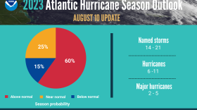
Record-warm ocean temperatures are likely to fuel the peak of hurricane season, scientists at the National Oceanic and Atmospheric Administration said Thursday.
-
Who ya gonna call?: Residents hit by Monday's tornado learn the do's and don't's of road to recoveryFor those who lost power in their homes due to the tornado that raced through Allentown on Monday, the first thought would be to call PPL. Think again.
-
It’s the peak of the annual Perseid meteor shower and WLVR’s Brad Klein speaks with a local amateur astronomer about how best to see meteors in the night sky.
-
An Allentown homeowner caught on video the moment an EF-1 tornado touched down in the city’s Midway Manor neighborhood on Monday night.
-
As cleanup continues from Monday’s severe weather, the Lehigh Valley will see a period of rain Thursday that could bring localized flooding to some areas.
-
The National Weather Service determined damages during a severe thunderstorm Monday night were from straight-line winds as high as 100 mph, but no tornadoes touched down there.
-
The National Weather Service rated the tornado as an EF-1 — the second-weakest on the scale. It hit the Midway Manor neighborhood of Allentown and crossed into Bethlehem briefly, according to a weather service statement.
-
A National Weather Service survey team confirmed a tornado touched down in Allentown’s Midway Manor neighborhood Monday night on the east side, but the twister was unwarned.
-
Starting at 9 a.m., officials from Princeton Hydro, a New Jersey-based engineering consultant, will treat the lake’s shoreline via airboat to tamp down invasive Phragmites, a genus of four species of large perennial reed grasses.


-
The Lehigh Valley stands alone as the only major climate site in the area with above-average snowfall this winter, but the pattern says winter could be just about over.
-
Brad Klein reviews the week’s astronomical highlights with Bethlehem’s "Backyard Astronomy Guy," Marty McGuire.
-
The Lehigh Valley Planning Commission last week released a draft of its Priority Climate Action Plan, a document almost a year in the making aimed at tamping down the region’s carbon emissions and mitigating the effects of climate change.
-
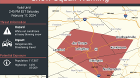
The National Weather Service issued the warning Saturday afternoon for parts of Lehigh and Northampton counties, extending into Carbon County.
-
Take a look at stories that ran throughout the week of which we are most proud, had a profound impact on readers or that you might want to look at again.
-
Five farms, three in Lehigh County and two in Northampton County, were the latest to be included in the commonwealth’s Farmland Preservation Program, along with more than a dozen others across the state.
-
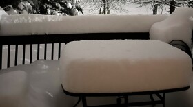
Some areas reported almost 14 inches of snow, with flakes the size of cotton balls. Other areas got just a few inches. Said a National Weather Service meteorologist: 'I completely understand the shock factor.'
-
The Lehigh Valley is under a winter weather advisory in effect from 10 p.m. Friday to 10 a.m. Saturday, with a chance the snowfall that could overperform in parts of the region.
-
WLVR's Megan Frank talks with journalists Molly Bilinski and Phil Gianficaro.
-
Presidents Day weekend is approaching, and historically the period has been prime time for big storms. That won't be the case Friday, but a few inches of snow are possible in the Lehigh Valley.
-
A Lehigh Valley resident was recognized as a “Volunteer of the Year” for 2023 by Keep Pennsylvania Beautiful, a statewide nonprofit that focuses on litter cleanups and community improvements.
-
Less than 24 hours removed from the Lehigh Valley’s heaviest snowfall in three years, forecasters have a word of advice to offer: don’t put the shovel away just yet.