Bethlehem Live Weather Camera sponsored by St. Luke's University Health Network
-
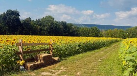
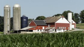
 More than 1,336 acres across the commonwealth were preserved. Here are the Lehigh Valley farms now safe from development.
 -
Take a look at stories that ran throughout the week of which we are most proud, had a profound impact on readers or that you might want to look at again.
-
Rainy weekends have put a damper on attendance at fall festivals in the Lehigh Valley.
-
A potent system is still on the way to the area, the National Weather Service warned Friday, referencing a storm forecasters have been talking about for almost a week.
-
The initiative consists of a partnership between Northside Alive and PPL — the latter donating 500 special lightbulbs to the community.
-
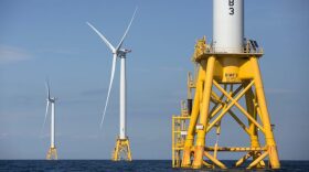
PennEnvironment released data showing Pennsylvania ranks near the bottom when it comes to the growth of wind energy, solar power, energy storage and other renewable energy metrics over the last decade.
-
A powerful storm system expected to bring heavy rain to the region this weekend might not be a total washout, forecasters say.
-
After Lafayette College cleared more than 40 trees for a $1.2 million walkway without city approval, no trees will be replanted on the hillside where they were removed, the city forester said. Instead, several dozen trees were planted across campus and in Easton.
-
An agreement between Bethlehem Landfill and the people suing them, reached Tuesday, limits the landfill’s work to expand while a series of lawsuits aimed at stopping the expansion go forward.
-
"This is something in winter a few months from now … this is a Miller B system [or nor’easter]. The difference is, temperatures are too warm for snow," EPAWA meteorologist Bobby Martrich said.


-
The Lehigh Gap Nature Center took to social media Monday to alert visitors and hikers to "use caution" with pets after dog treats were found with fish hooks planted inside them.
-
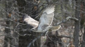
The spring migration count at Hawk Mountain began last month. One-day peak counts reach more than 100 birds in mid- to late-April, with this season’s count continuing through May 15.
-
This week, Brad and Marty discuss images that McGuire acquired from India’s space program. The images show the first steps by man on the moon.
-
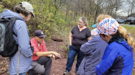
Pennsylvania Master Naturalist is partnering with the Lehigh County Conservation District to host a Master Naturalist Volunteer training. The course aims to bolster local conservation efforts.
-
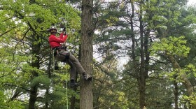
A Montour County environmental educator, arborist and musician is attempting to climb the tallest tree at the highest point in each of the Commonwealth’s 67 counties.
-
One person who consumed raw milk from Apple Valley Creamery in East Berlin and became ill, officials said. The milk is sold in three Lehigh Valley locations.
-
The annual scholastic competition combines classroom learning and outdoor activities to engage students in environmental science. The state competition is scheduled for May 22 in Mifflinburg.
-
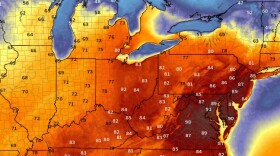
Toasty has been the word to describe the Lehigh Valley’s weather this week, but forecasters say we’re about to cool off in a big way. They're expecting a big drop in temperatures to go along with our wet weekend.
-
Carbon County officials on Thursday will sign on to a partnership with Northampton, officials announced. Their goal is to bolster farmland preservation efforts.
-
Arcadia plans to tear down the SureStay Plus Hotel by Best Western at 300 Gateway Drive off Route 512 and replace it with a 250,000-square-foot warehouse. If the permit is approved, developers will be allowed to discharge stormwater from construction activities into the Monocacy Creek.
-
C.F. Martin & Company has unveiled a vivid new museum display focused on sustainable manufacturing practices, highlighting years of innovations which focus on quality instruments with an environmentally-friendly orientation.
-
A sun-splashed Sunday may have felt like the beginning of summer, but temperatures Monday soared into record-breaking territory, the National Weather Service said.