Bethlehem Live Weather Camera sponsored by St. Luke's University Health Network
-
 A local initiative to develop a sustainable farm food infrastructure was instrumental in Pennsylvania Secretary of Agriculture Russell Redding choosing to appear in Easton to announce the theme for the 2024 state Farm Show in Harrisburg.
 -
A new tool announced Tuesday lets Bethlehem Township residents report flooding and other stormwater issues which are common in the township.
-
Wildlands Conservancy bought the Carbon County land, which included a Lehigh River tributary, transferring ownership to the state Game Commission. Advocates aim to ward off development and protect the health of the river.
-
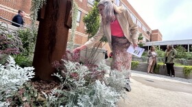
'There's nothing healing about concrete': Local artist's dream of a healing garden comes to fruitionA community healing garden is now open to patients and the public at Lehigh Valley Hospital Muhlenberg. Peter Yenawine, along with the Auxiliary of Lehigh Valley Hospital and master gardeners, teamed up to create the space incorporating native and medicinal plants.
-
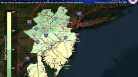
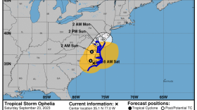
The remnants of Ophelia will drift slowly southward and offshore through Wednesday, the National Weather Service said, bringing a raw start to the week for the Lehigh Valley.
-
In a recent national report, Pennsylvania received a failing grade in its regulation and treatment of lead in schools’ water. Six local schools have reported unacceptable levels of lead since 2018, and one expert says some of the remediation methods they used are less than perfect.
-
No longer a tropical storm, the remnants of Ophelia will have an impact on the Lehigh Valley weather at least into Tuesday, according to the National Weather Service forecast. Expect showers throughout Sunday.
-
Take a look at stories that ran throughout the week of which we are most proud, had a profound impact on readers or that you might want to look at again.
-
A sunrise observance was held Saturday at the private, nonprofit park to mark the transition from summer to fall. The park features dozens of stone settings strategically placed throughout more than 20 acres.
-
The storm is expected to cause heavy rainfall across the Mid-Atlantic states, potentially leading to flash and urban flooding. Easton's PorchFest has been postponed to Oct. 1.


-
The Lehigh Gap Nature Center took to social media Monday to alert visitors and hikers to "use caution" with pets after dog treats were found with fish hooks planted inside them.
-
The spring migration count at Hawk Mountain began last month. One-day peak counts reach more than 100 birds in mid- to late-April, with this season’s count continuing through May 15.
-
This week, Brad and Marty discuss images that McGuire acquired from India’s space program. The images show the first steps by man on the moon.
-
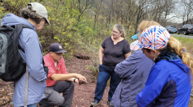
Pennsylvania Master Naturalist is partnering with the Lehigh County Conservation District to host a Master Naturalist Volunteer training. The course aims to bolster local conservation efforts.
-
A Montour County environmental educator, arborist and musician is attempting to climb the tallest tree at the highest point in each of the Commonwealth’s 67 counties.
-
One person who consumed raw milk from Apple Valley Creamery in East Berlin and became ill, officials said. The milk is sold in three Lehigh Valley locations.
-
The annual scholastic competition combines classroom learning and outdoor activities to engage students in environmental science. The state competition is scheduled for May 22 in Mifflinburg.
-
Toasty has been the word to describe the Lehigh Valley’s weather this week, but forecasters say we’re about to cool off in a big way. They're expecting a big drop in temperatures to go along with our wet weekend.
-
Carbon County officials on Thursday will sign on to a partnership with Northampton, officials announced. Their goal is to bolster farmland preservation efforts.
-
Arcadia plans to tear down the SureStay Plus Hotel by Best Western at 300 Gateway Drive off Route 512 and replace it with a 250,000-square-foot warehouse. If the permit is approved, developers will be allowed to discharge stormwater from construction activities into the Monocacy Creek.
-
C.F. Martin & Company has unveiled a vivid new museum display focused on sustainable manufacturing practices, highlighting years of innovations which focus on quality instruments with an environmentally-friendly orientation.
-
A sun-splashed Sunday may have felt like the beginning of summer, but temperatures Monday soared into record-breaking territory, the National Weather Service said.