Bethlehem Live Weather Camera sponsored by St. Luke's University Health Network
-
 A local initiative to develop a sustainable farm food infrastructure was instrumental in Pennsylvania Secretary of Agriculture Russell Redding choosing to appear in Easton to announce the theme for the 2024 state Farm Show in Harrisburg.
 -
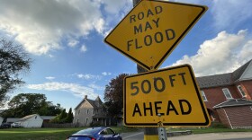
A new tool announced Tuesday lets Bethlehem Township residents report flooding and other stormwater issues which are common in the township.
-
Wildlands Conservancy bought the Carbon County land, which included a Lehigh River tributary, transferring ownership to the state Game Commission. Advocates aim to ward off development and protect the health of the river.
-
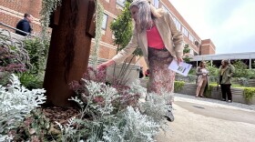
'There's nothing healing about concrete': Local artist's dream of a healing garden comes to fruitionA community healing garden is now open to patients and the public at Lehigh Valley Hospital Muhlenberg. Peter Yenawine, along with the Auxiliary of Lehigh Valley Hospital and master gardeners, teamed up to create the space incorporating native and medicinal plants.
-
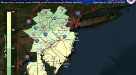
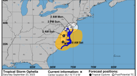
The remnants of Ophelia will drift slowly southward and offshore through Wednesday, the National Weather Service said, bringing a raw start to the week for the Lehigh Valley.
-
In a recent national report, Pennsylvania received a failing grade in its regulation and treatment of lead in schools’ water. Six local schools have reported unacceptable levels of lead since 2018, and one expert says some of the remediation methods they used are less than perfect.
-
No longer a tropical storm, the remnants of Ophelia will have an impact on the Lehigh Valley weather at least into Tuesday, according to the National Weather Service forecast. Expect showers throughout Sunday.
-
Take a look at stories that ran throughout the week of which we are most proud, had a profound impact on readers or that you might want to look at again.
-
A sunrise observance was held Saturday at the private, nonprofit park to mark the transition from summer to fall. The park features dozens of stone settings strategically placed throughout more than 20 acres.
-
The storm is expected to cause heavy rainfall across the Mid-Atlantic states, potentially leading to flash and urban flooding. Easton's PorchFest has been postponed to Oct. 1.


-
Northampton County's Parks and Recreation Division and the Lehigh Valley Greenways Conservation Landscape celebrated big anniversaries Monday during the Greenways Jamboree Monday at Wayne Grube Memorial Park.
-
State officials are holding a virtual town hall meeting Wednesday for residents to share their feedback on the Bureau of Forestry’s newest strategic plan. Here's how to participate.
-
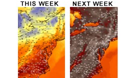
The weather pattern this week will be a tale of two halves, with sunny skies and comfortable temperatures before things heat up in a big way. The region's first heat wave could also be looming, forecasters warn.
-
In this week's Watching the Skies, Brad Klein and Marty McGuire talk about how China landed a spacecraft on the far side of Earth's moon on June 1 to gather rock and soil samples.
-
The release is the first of a long list of fun summer activities planned for young readers at the library.
-
Officials gathered at the Lehigh Valley Zoo Thursday evening for a ribbon cutting to celebrate the opening of Rothrock Red Panda Peak. It's the first time the zoo has had red pandas in residence.
-
The complaint alleges Sunshine Act violations from the township supervisors and legal filings from the township solicitor with no official approval beforehand.
-
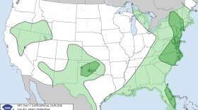
The Storm Prediction Center has maintained a marginal risk (1 out of 5) for the Lehigh Valley and surrounding areas Thursday, with the primary threat being damaging winds.
-
Environmental and county officials this week began dismantling a dam over Bushkill Creek in an effort to restore the creek. The removal will improve water quality, stormwater function and connectivity for fish and other organisms.
-
“The pleasant stretch of weather we encountered early in the week is beyond us,” the National Weather Service said in its latest forecast discussion, with the Lehigh Valley at risk of excessive rainfall Wednesday.
-
After a raging fire on Saturday night destroyed his Center Valley barn, tractors, trucks and equipment, Leroy C. Stahler Jr. vows to rebuild and continue the Stahler family legacy of farming, said his daughter, Tracy Beers.
-
While monitoring continues, Lehigh Valley Breathes officials used the most recent project update to explain results from the research this spring at Lehigh University.