Bethlehem Live Weather Camera sponsored by St. Luke's University Health Network
-
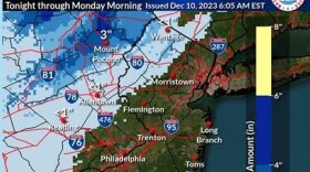
 Many spots could receive 2 to 3 inches of rain, forecasters warn, with areas of flooding possible Sunday night as another coastal storm targets the region.
 -
Amid the joy and festivities, environmental advocates are urging residents to keep sustainability in mind during what can be a time of year when trash and waste spikes.
-
State environmental officials on Thursday evening hosted the last of five public engagement sessions, as they work to create a Priority Climate Action Plan, or PCAP, aiming to reduce greenhouse gas emission statewide and mitigate further effects of climate change.
-
Forecasters say another impactful storm is expected to move up the coast, bringing heavy rain and gusty winds to the region Sunday into Monday.
-
The new official map marks recently acquired land, while setting priorities for future desired open space.
-
A Tuesday evening webinar cosponsored by the Bethlehem Area Public Library and Bethlehem Food Co-Op focused on how residents can meaningfully participate in the city’s efforts to fight climate change.
-
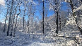
The Lehigh Valley remains devoid of accumulating snow events so far in December —and it looks like that pattern will continue straight through the holiday season.
-
Brad Klein reviews the week’s astronomical highlights with Bethlehem’s 'Backyard Astronomy Guy," Marty McGuire.
-
Sunday's rain could transition to snow as the storm system departs the region Monday morning, with the potential to affect the morning commute, according to the National Weather Service.
-
The U.S. Department of Agriculture updated its plant hardiness map, showing a warmer Lehigh Valley. The region has moved into a warmer zone from the one where it was placed more than a decade ago. Experts say it has consequences for plant seasons and species.


-
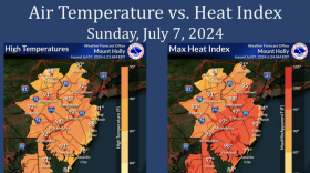
Another heat advisory has made its way to the Lehigh Valley, accompanied by an air quality alert. While temperatures aren't expected to be as high as the last heat wave, the heat index could still hit triple-digits Monday and Tuesday.
-
Cars were running and appeared ready to roll Saturday morning at the site of Friday's multi-car derailment.
-
More than two dozen dinosaurs are on display at the Allentown Fairgrounds Agri-Plex through Sunday night.
-
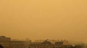
Possible showers and thunderstorms will provide little relief from the humidity over the next several days, according to the National Weather Service.
-
This Fourth of July in the Lehigh Valley, the fireworks in the sky might come from Mother Nature. There's a storm threat, and some will be capable of producing very heavy rain that could lead to localized flash flooding.
-
The Climate Prediction Center is favoring warmer than normal temperatures for the Lehigh Valley, which has an average daily high of 86.4 degrees in July, according to data from the National Weather Service.
-
A Mars-themed event at Bethlehem Area Public Library will focus on NASA rovers Curiosity and Perseverance. Registration is encouraged.
-
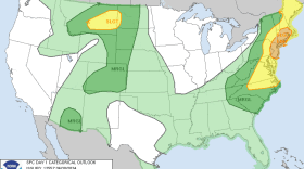
The National Weather Service's storm prediction center shows the Lehigh Valley falling in line with forecasts of high winds, potential hail and some severe thunderstorms Sunday evening.
-
That clash of fantasy and education worlds comes to Ag Hall at Allentown Fairgrounds July 5-7, when Jurassic Quest, which bills itself as North America’s most popular interactive dinosaur event, returns to Allentown.
-
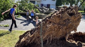
Days after ferocious storms barreled through the region, ripping down trees and power lines, the Lehigh Valley could be at risk of additional rounds of severe weather this weekend.
-
Thousands of customers are still left without power following a series of storms that hit the Lehigh Valley. High winds yielded downed wires and tree limbs across homes and roadways throughout the area.
-
Downed trees and power outages were the result of a powerful storm that pounded the Lehigh Valley on Wednesday night.