Note: First of two parts. Read part 2.
BETHLEHEM, Pa. — As deadly flash floods dominate headlines this summer, climate scientists are issuing a stark reminder.
The devastation seen in Texas in early July isn’t just a Texas problem — it’s a warning to communities across the United States, including the Lehigh Valley.
“We hear over and over again that people say that, you know, it couldn't happen here, or it can't happen here for whatever reason,” said Dr. Daniel Swain, a climate scientist at the University of California.
“You know who you never hear saying that?” Swain said. “Meteorologists. Hydrologists. Or if it's an earthquake, seismologists. Whoever actually studies the thing that ‘can’t happen here.’”
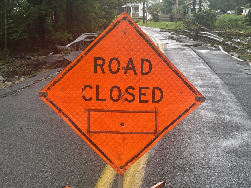
Situated in a literal valley with two major rivers, coupled with seemingly constant development creating more impervious surfaces, the Lehigh Valley is no stranger to devastating flooding.
Following a months-long drought, the region this summer has seen a train of storms, saturating the landscape.
And with more storms expected later this week, officials are on high alert for more flash flooding.
“We are definitely at a heightened risk because we do have more impervious surfaces,” Christa Kelleher, a hydrologist and assistant professor at Lafayette College, said Thursday during an Eason event focused on extreme weather events and climate change.
“We are also in sort of a bowl down here, right? And so topography is also working against us. So anywhere that you are in a city … we can have flooding that comes out of the river right into the area.
"We can also have what's called pluvial, or urban flooding, where you are getting too much water moving over the top and it can't get into those storm sewers fast enough.”
And, in fact, July 2025 has been the month of flooding downpours and of extreme humidity.
According to NOAA, from July 1-15 there were more than 1,200 flooding reports nationwide — about 75% above average.
The trend is part of what Swain describes as a pattern of increasingly frequent and intense short-term downpours, fueled by a warming atmosphere loaded with tropical moisture.
“This is one of those predictions that's actually increasingly validated by looking at the data unfolding all around us,” he said.
“There have been an incredible number of flash flood events and extreme precipitation events ... a lot of the Eastern U.S. has been either flirting with or exceeding record high atmospheric water vapor content values for good portions of the summer.”
A misunderstood risk
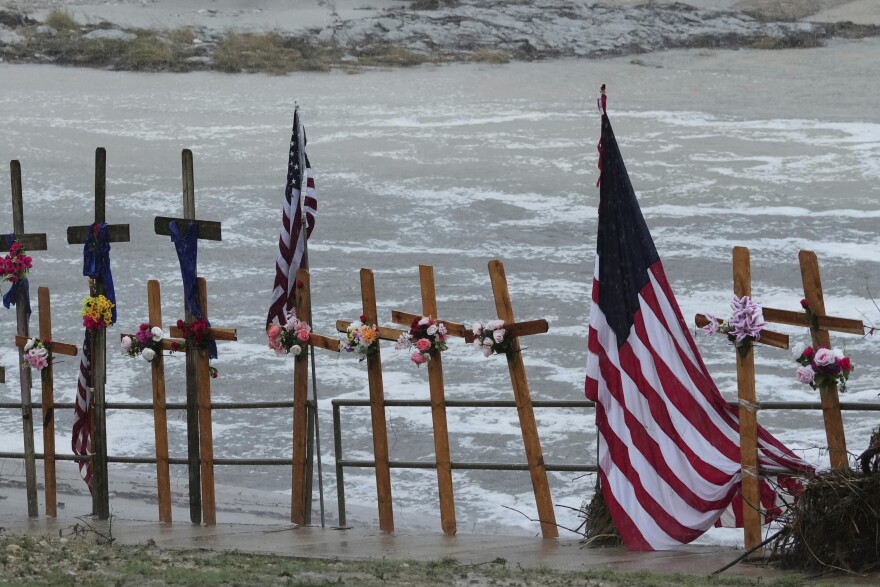
Swain pointed to the catastrophic event July 4 in the Texas Hill Country as a key example of how deadly flash floods can form quickly, and in places people least expect.
At least 135 people were killed by historic flooding when a summer’s worth of rain swelled the Guadalupe River, overwhelming drought-dried soil.
The catastrophic event stoked harsh criticism from residents and even conspiracy theories.
“It evolved over two or three hours — a wall of water that from rain that wasn’t even falling three hours previous killed a lot of people."Daniel Swain, a climate scientist at the University of California
“It evolved over two or three hours — a wall of water from rain that wasn’t even falling three hours previous killed a lot of people,” he said.
“It’s not even the wettest part of East Texas, and yet it is definitely the most flash flood vulnerable part of the state.”
Similar to Kelleher, Swain said the vulnerability lies in the intersection of heavy rainfall and geography.
Thin soil layers, impermeable limestone and deep valleys mean rain can’t soak into the ground and instead rushes into low-lying areas.
And while the specific conditions of the Texas flood were unique, the general setup isn’t foreign to Pennsylvania.
“You have some mountains — more substantive mountains, actually, than that part of Texas — in relatively close proximity to a fairly warm body of water, the Atlantic Ocean,” he said.
“When conditions align, you can get increasingly intense downpours in a place that has mountains and valleys, and therefore rivers and creeks and streams in the valleys in between them that are really susceptible to flooding.”
Valley also vulnerable to flooding
The Lehigh Valley’s geography and topography can make it particularly vulnerable to flash flooding.
Situated in a literal Valley between Blue Mountain and South Mountain, both the Lehigh and Delaware rivers, as well as a slew of tributaries, carve through the landscape.
And then there’s the constant beat of climate change.
"If we think that we at the local level are going to be able to escape paying more and more money to ameliorate the damages from these torrential downpours, we are mistaken, and we have evidence of that already.”Northampton County Executive Lamont McClure
“The California wildfires last year, the horrible flash flooding in Texas this year, our own biblical downpours in July of 2023 demonstrate to us that our climate is changing," Northampton County Executive Lamont McClure said.
"And that it is causing more severe weather to occur on a more frequent basis. It seems like every other year, every two or three years, we're having 500-year or 1,000-year rains.”
In July 2023, about a month’s worth of rain fell in parts of the area in one day, causing more than $10 million worth of damages to a dozen municipalities, as well as county bridges.
“In that July 2023 deluge, we had three bridges either lost or damaged on Little Creek Road, and the county taxpayer had to pay to fix them,” McClure said.
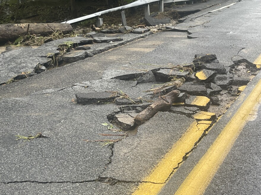
“It ended up being a half a million dollars to do that. There was no federal money to fix them, no state money to fix them.
"So if we think that we at the local level are going to be able to escape paying more and more money to ameliorate the damages from these torrential downpours, we are mistaken, and we have evidence of that already.”
No federal disaster declaration was issued.
The last time Northampton County saw a declaration was in 2021, after Hurricane Ida caused river levels to rise throughout the county, with the Lehigh River edging out over 13 feet in Walnutport and 19 feet in Bethlehem.
The river crested to major flood stage in Glendon hitting just over 24 feet.
Tropical air in unlikely places
Eastern Pennsylvania and the broader Mid-Atlantic have been feeling unusually tropical this summer. Some days, the dew point here has surpassed what’s typical in Florida.
“There’s a tremendous amount of tropical moisture in the air,” Swain said. “This is actually air that has been transported from the subtropics or even the tropics to places that are definitely not the tropics.”
He explained that it isn’t just a matter of more humid days — the influx of moisture directly raises the ceiling on how intense rainfall can be.
“If storms are present, then they have a lot more water vapor to work with than they used to,” he said.
That scenario played out recently in our neighboring states.
Swain noted parts of New Jersey saw some of the heaviest rain on record just recently, and New York City's Central Park has experienced some of the most intense downpours in its history over the past three or four years.
Pennsylvania Emergency Management Agency Director David “Randy” Padfield said flooding is a common hazard across the commonwealth due to “a combination of variables.”
“I think some of them are climate related, and what we're seeing with some of the trending,” Padfield said.
“We have five decades worth of data that shows us that in the northeast states, from Pennsylvania all the way up to Maine, there is a steady increase in severe precipitation events that are short duration, high intensity.”
Being an older state, Pennsylvania has a lot of infrastructure that, historically, was built along water.
“So there are a lot of folks [who] like to live next to the water,” he said. “There's a lot of infrastructure that's built next to the water.
"We have a significant amount of creeks and streams and rivers that are throughout the state. And I think that's another kind of factor that we take a look at.”
'Comes down to the warning'
Asked about similarity to Texas flooding, Padfield said Pennsylvania isn’t immune to riverine flooding, but that’s not the main flooding concern.
“We're not immune to flooding along the river basins, because we still have that risk,” he said.
“What we're seeing is more of a transition to flash flooding scenarios because of that increase in severe precipitation events and having a lot of precipitation over a very short period of time.”
July 15 marked the two-year anniversary of deadly flash flooding in Bucks County, when Houghs Creek, a tributary of the Delaware River, overflowed in Upper Makefield Township and killed seven people.
After waters receded, Padfield was at the site, surveying the damage and trying to piece together what happened.
“They got out of their vehicles because they were stranded, and the water just swept them away,” he said. “And it's terribly tragic when that happens, especially when we see the situations like in Texas and those types of things.
“And a lot of it comes down to the warning — the other side of that is making sure people heed the warning, right?
"We want them to do the right thing, and they don't realize they're in a bad situation, and they're overcome because they've never operated in that kind of environment before, so they don't know the force of moving water and what it can do.”
Not a forecast failure
When people are caught off guard, it’s easy to blame the forecast. But Swain pushed back on that narrative.
“[Texas] was not a forecast failure. It was a failure to understand the forecast."Daniel Swain, a climate scientist at the University of California
“[Texas] was not a forecast failure," he said. "It was a failure to understand the forecast.”
He referenced both the Texas disaster and recent Northeastern floods.
“It was definitely in the forecast that it would happen somewhere, but not that it would happen, you know, at some pinpoint location,” he said.
The problem, Swain argues, is that public officials often aren’t well-versed in interpreting forecasts that describe widespread but localized risks — such as flash floods from slow-moving summer storms.
“It’s pretty clear that some officials, local level, state level, don’t really understand the limits of weather prediction," he said.
"That is not necessarily their fault ... but if your job is to prepare for emergencies, then you really do need to be talking to the meteorologists.”
That gap in understanding leads to missed opportunities for proactive action, he said.
While New Jersey declared a state of emergency during the recent deluge, Pennsylvania — despite being similarly threatened — did not.
Swain said such a reactive posture is common, and dangerous.
“It's kind of the same repeating general pattern of well-predicted risk — high-risk flash flood days, but then very intense, localized events that everyone says wasn't in the forecast and took them by surprise despite explicitly being in the forecast,” Swain said.
Coming tomorrow: How federal funding cuts could affect storm preparedness, response in the Lehigh Valley.