Note: Second of two parts. Read part 1 HERE.
BETHLEHEM, Pa. — State-level emergency management officials are seeing an alarming weather trend: Extreme amounts of rain, falling very quickly.
“We saw those types of situations where it's severe precipitation over a very short period of time," state Emergency Management Agency Director David "Randy" Padfield said.
"It's not the entire county, it just impacts smaller municipalities, but it is incredibly devastating to them. And they're the types of situations that we're seeing right now.
"And we track those as best possible here, because obviously, there are impacts in the local community, and smaller municipalities may not have the funding available to be able to recover from those.”
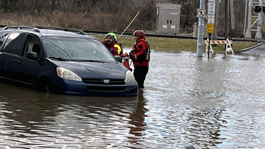
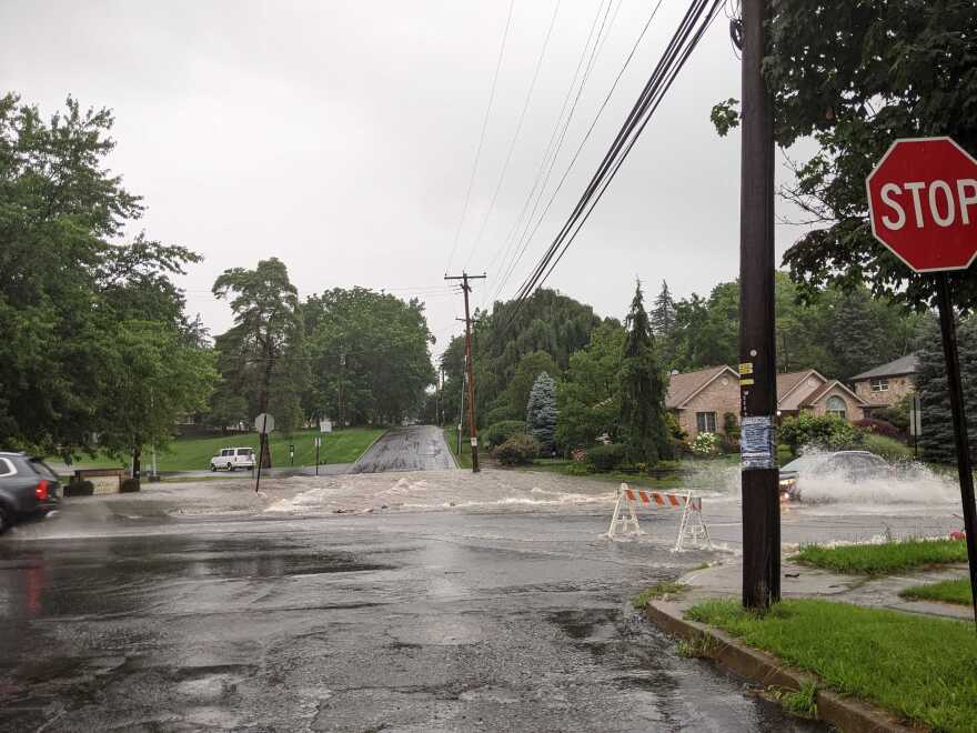
In Pennsylvania, flooding is the most common hazard.
And with federal funding for extreme weather forecasting, preparedness and mitigation already cut or on the chopping block, local officials are warning it could have devastating effects locally, including in the Lehigh Valley.
“A lot of individuals don't understand that their homeowners insurance does not cover them for flooding. And, you know, they're more apt to be flooded in the commonwealth of Pennsylvania over the lifespan of a 30-year mortgage than they are to actually have a fire."Pennsylvania Emergency Management Agency Director David “Randy” Padfield
“A lot of individuals don't understand that their homeowners insurance does not cover them for flooding,” Padfield said.
“And, you know, they're more apt to be flooded in the commonwealth of Pennsylvania over the lifespan of a 30-year mortgage than they are to actually have a fire.
"But their homeowners insurance will cover them for fire; won't cover them for flooding unless they have a specific rider on or they're required to have it because they're in a special flood hazard zone.”
‘The basin has seen it all’
One of the Valley’s two major rivers, the Delaware, has seen catastrophic flooding.
Its flood of record, in August 1955, led to the creation of the Delaware River Basin Commission less than a decade later.
However, there have been many floods — several devastating — since then.
Noting the historic floods almost a century ago, Amy Shallcross, manager of water resource operations for DRBC, said there were serious floods in 2004, 2005 and 2006.
“I think the basin has seen it all."Kate Schmidt, communications specialist for the Delaware River Basin Commission
Those flooding events were caused by Tropical Storm Ivan; a combination of saturated soils, snowmelt and heavy rains; and a stalled frontal system, respectively.
“The 21st century came around, and we had three quote-unquote, 100-year floods in a row," Shallcross said. "But I think that 100-year flood is a little bit of a misnomer.
“All that means is that you have a 1 percent chance of getting a flood of that magnitude in any given year.”
The Delaware River Basin, which covers 13,539 square miles in four states, can flood for myriad reasons and throughout the year, Kate Schmidt, communications specialist for the DRBC, said.
They include tropical storms and hurricanes, as well as ice jam flooding.
“I think the basin has seen it all,” Schmidt said.
“As conditions and hydrology get a little more extreme, we can get into patterns where we are seeing more flooding, not necessarily completely main stem flooding, but obviously tributary flooding, flash flooding and the like.”
Flooding is incredibly dependent on the conditions that precede a storm, Shallcross said.
“And typically, it's either very, very wet conditions, or you have a rain-on-snow event,” Shallcross said.
“And so, then the other thing that changes is how the precipitation falls over the watershed, the entire basin, and what the intensity of that precipitation is throughout the storm event … We've had a couple instances where we've had back-to-back storms.
“Sometimes that happens because the first storm basically fills up the river and saturates the ground and then the second storm is really what the flooding results in.”
‘StormReady counties’
Both Lehigh and Northampton counties are considered “StormReady” counties through the National Weather Service.
“Which means that we promote practicing the use of numerous alert systems during life threatening events, and that would be alerts coming from the wireless emergency alert system via mobile apps and from local officials,” Northampton County Executive Lamont McClure said.
“For example, in Northampton County, we put it on our social media and NOAA Weather Radio Network.”
Describing an “all-hazard approach” during an extreme weather event, McClure said that after 911 calls are made, first responders are dispatched to emergencies.
“911 calls get routed, and emergency personnel are dispatched,” he said. “Now, if the municipality becomes overwhelmed, they have mutual aid agreements with other municipalities who come to their aid.
“And if it gets larger than the mutual aid agreements can compensate for, then the county comes in to quarterback it all.
"The county doesn't take control, but emergency management comes in to help coordinate the response, and then if the disaster exceeds the county capabilities, then the state and federal government come in.”
Asked whether forecasting and preparedness has gotten better with technology, Padfield said it has.
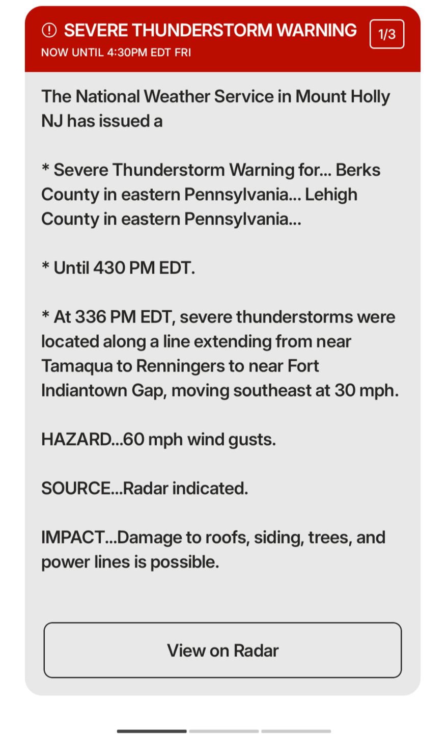
“We base a lot of the decisions we make here from the state level on what's called the excessive rainfall outlook. It's by the Weather Prediction Center, and they produce what's considered the ERO.”
When the ERO is moderate, “we start taking action, from our perspective, to make sure that we can shorten reaction time if the counties need additional resources,” he said.
“They're very helpful in telling us that the conditions are right, that something may happen. The one thing they're not good with is where it's going to happen.
"It kind of paints it as a broad brush, and then during the event, we really work with our state meteorologists and the National Weather Service offices to kind of nowcast those.”
The cost of inaction
Daniel Swain, a climate scientist at the University of California, warned of an even more concerning trend: Efforts to improve predictions and communication are at risk of being defunded.
“All of these weak points were being actively addressed by NOAA and their university and national lab research partners,” he said.
“And all of that research is at immediate risk of just disappearing off the face of the Earth in the next few months with this proposed budget.”
President Donald Trump and the U.S. Department of Government Efficiency have cut hundreds of jobs at the National Weather Service.
In April, federal officials announced the end of FEMA’s Building Resilient Infrastructure and Communities program.
In response, Pennsylvania, and a slew of other states, are suing the administration.
“If FEMA funding is cut and policies are changed, Northampton County could be left without the federal support we rely on to respond quickly when disasters strike.”Northampton County Executive Lamont McClure
“We need to make sure FEMA funding stays constant and actually grows and is not cut, because it is a lifeline,” McClure said.
“If FEMA funding is cut and policies are changed, Northampton County could be left without the federal support we rely on to respond quickly when disasters strike.”
Call for restored funding
Last week, local officials and environmental experts gathered in Easton to criticize the cuts and call on officials to restore funding for weather emergency research and programs.
Swain and others called on the public to recognize the stakes and pressure lawmakers to restore funding.
“If this is something that is important to you, then say that to your local representatives,” he said.
“We are actively making decisions at a federal level right now about whether or not we do better at any of these things or get worse at them.”
From a forecast perspective, meteorologist Bobby Martrich of EPAWA Weather Consulting said the cuts have affected things such as the launch of weather balloons and availability of observational data.
“This affects the model guidance that relies on this critical information to produce forecast simulations,” Martrich said.
“Our sole mission, along with the National Weather Service, is to protect life and property. If we are handcuffed by lack of critical data, that makes messaging dangers that much more difficult."Bobby Martrich of EPAWA Weather Consulting
He emphasized that he’s noticed a significant decrease in overall accuracy with short-range, medium-range and longer-term guidance.
“Our sole mission, along with the National Weather Service, is to protect life and property," Martrich said. "If we are handcuffed by lack of critical data, that makes messaging dangers that much more difficult."
And without a fully funded FEMA, and if PEMA can’t cover the deficit, “it's going to be harder for us to prevent the damage that occurs when we have these 500, 1,000-year events,” McClure said.
“Just some of the potential ramifications of the cuts from FEMA and the changes in policy, it cripples our ability to respond quickly and effectively to emergencies,” he said.
“Federal aid really is the backbone of our disaster recovery. It supports local emergency operations, infrastructure repairs and relief for our residents.
"Without it, we risk leaving our communities exposed and unprepared. So any changes in FEMA policy and any cuts to the FEMA budget and the PEMA budget are going to adversely affect us here locally.”
Hazard mitigation plans
Every county should have a hazard mitigation plan, Padfield said.
“It is a requirement, or at least was under the previous FEMA administration, I think it still is, to receive federal disaster support,” he said.
“And then there is a requirement for the municipalities to participate in the county's hazard mitigation plan. So they have to show up. They have to provide input into that.
"And FEMA, prior to the administration change — we're not sure you know what it's going to look like with the new administration — but if the county would come to us, or a municipality would come to us with a hazard mitigation project, FEMA would actually go back through and make sure that they participated in the plan development.
“They wanted to make sure that they signed in on the attendance rosters for the meetings, they provided input to the county and everything else in the development of that plan, because they wanted them to be active participants.
"And by being active participants, then, if there was a project that could be funded, then they'd entertain that project for funding.”
In the Valley, hazard mitigation plans for both Lehigh and Northampton counties have been combined into the Lehigh Valley Hazard Mitigation Plan.
It covers 25 natural and non-natural hazards, with extreme temperatures and flooding ranking among the highest risk factors in both counties.
Better messaging, clearer warnings
When it comes to public messaging, Swain said, the weather service already is using extreme language — “life-threatening,” “catastrophic,” “you will not survive”— in the most dire warnings.
But if people aren’t tuned in to the difference between a standard warning and a rare flash flood emergency, the words lose power, he said.
“I don't think anybody seems to have been aware there was a difference, because I don't think people listen to these messages,” Swain said.
“More importantly, local officials also did not understand it, and that was a big problem.”
As for the growing use of terms such as “extreme heat,” Swain said he expects “extreme flooding” and similar phrases to become more common — if only to break through the noise of hype and misinformation on social media.
"In some cases, by the time they get the warning, it shortens their reaction window to be able to take appropriate action, to be able to avoid flood waters, not driving through moving water, those types of things."State Emergency Management Agency Director David "Randy" Padfield
“We’re living in an era where everything feels extreme, whether it truly is or is perhaps just nearly unusual,” he said. “And yet we’re also living in an era where many things actually are becoming more extreme.”
It’s pretty much impossible to totally eliminate flooding as a hazard, but residents can boost their resilience by paying attention to weather-related warnings, officials said.
“What we're seeing a lot of times is nowadays, with the way the systems are set up, we want people to be weather-aware and understand that conditions are right for severe precipitation events, and they should monitor the conditions,” Padfield said.
“Because, in some cases, by the time they get the warning, it shortens their reaction window to be able to take appropriate action, to be able to avoid flood waters, not driving through moving water, those types of things.
"So we want them to be weather-aware.”
'This is really happening'
One concern is weather warning fatigue, or alert fatigue, where people become desensitized to weather alerts due to frequent or repeated notifications.
“The ‘boy that cried wolf’ complacency becomes an issue — where one or multiple warnings are issued and then very little or nothing happens for one’s backyard," even if severe weather hit neighboring areas.
“The alternative to that is complacency and ignoring future warnings because the last one or last few didn’t work out for their area."Bobby Martrich of EPAWA Weather Consulting
"So they bash the meteorologists and potentially ignore future warnings that may be legit,” Martrich said.
“This part I have no control over,” he said, outlining how the National Weather Service has the sole responsibility of dissemination of any warnings.
“There needs to be one dissemination source or there would be chaos if weather agencies like mine were issuing their own advisories,” he said.
And while the frequency of those alerts has increased, perhaps at times when storms weren’t strong enough for a "severe" designation, he said it’s better to be safe than sorry.
“The alternative to that is complacency and ignoring future warnings because the last one or last few didn’t work out for their area,” he said.
Swain summed up the challenge with a striking metaphor.
“We’re in this moment of social media hype [with forecasting] where it’s difficult to cut through, because everything is hyped," he said.
"And yet, you know, the expert in wolves is looking out there and saying, ‘Wow, there sure are a lot more wolves than there were a few years ago. For real. This is really happening.’”