

BETHLEHEM, Pa. — Brutal heat and humidity are expected through Wednesday in the Lehigh Valley before a full-fledged pattern change, forecasters say.
Allentown quietly set a record high temperature of 96 degrees on Friday, breaking the old record of 95 set in 1993, 1949, 1999 and 2016.
More records are in jeopardy this week, with a heat advisory in effect for much of the region both Tuesday and Wednesday as heat indices between 100 and 105 are expected, the National Weather Service said.
A breakdown of the days ahead
Monday
Temperatures are expected to rise during the afternoon into the low- to mid-90s while dew points remain right around 70. As a result, heat indices are expected to rise into the upper 90s to low 100s across the region.
The records to watch: 97 degrees set in 1949 / record warm low of 75 in 1934
Tuesday and Wednesday
Tuesday and Wednesday look quite similar weather-wise, the weather service said in its latest forecast discussion.
Dangerous heat and humidity are expected both days as temperatures climb into the mid- to-upper 90s.
“With dew points in the upper 60/low 70s, heat indices look to get into triple digits both days," the discussion said. "As a result, a heat advisory was issued for areas where criteria for an advisory is between 100-105 heat index.”
The records to watch: Highs of 96 on Tuesday (1954) and 97 on Wednesday (1940), while record warm lows are 75 (2002) and 74 (2024).
Major shift late-week; flash flooding concerns
An outbreak of cooler air will be felt later this week, forecasters say, with high temperatures expected to be cut down 10 to 20 degrees.
But prior to its arrival, Thursday is expected to be a wet and stormy day across the region.
“It will feel downright tropical overall with efficient rainfall producers Thursday into Thursday night.”National Weather Service discussion
“What is concerning is that there is rather high confidence in PWATs [precipitable water values] pushing above 2 inches, a signal that has been in the deterministic guidance for a few days now,” the weather service said in its forecast discussion.
“It will feel downright tropical overall with efficient rainfall producers Thursday into Thursday night,” the discussion said.
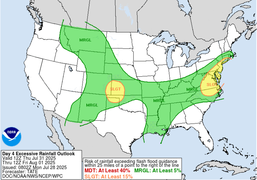
The Weather Prediction Center has the area at a slight risk (2 of 4) of excessive rainfall, which the weather service said “matches our thinking as well that it could potentially be a day to watch for flash flooding.”
It said current guidance suggests the probability of more than 1 inch of rain on Thursday at nearly 50% across the entire area.
Temperatures finally will start to feel better Friday, with highs in the upper-70s to low-80s under mostly sunny skies.
“Early indications are that it could perhaps be the nicest weekend of the summer,” the forecast discussion said.
