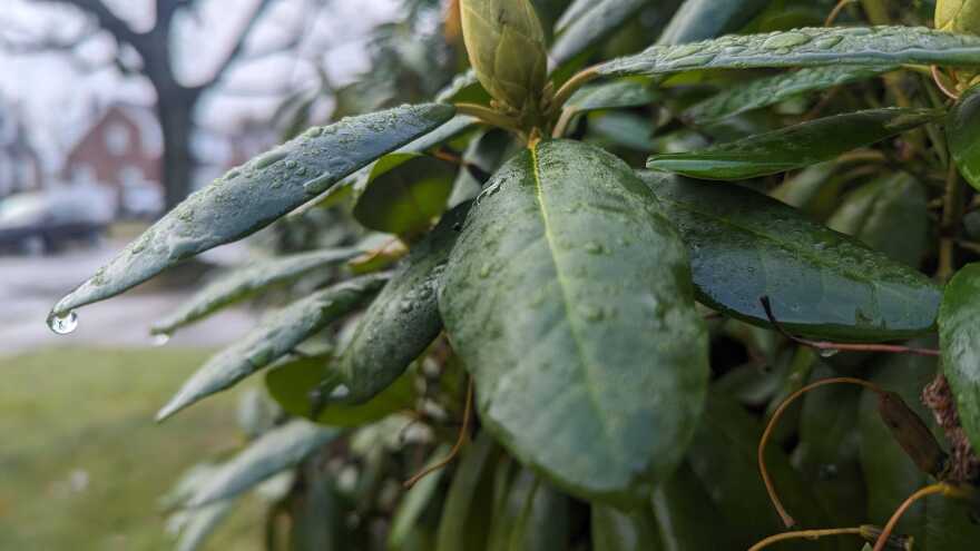
BETHLEHEM, Pa. — In the midst of back-to-back days of stormy weather, as the Lehigh Valley’s trees and shrubs boast new spring growth, it’s hard to believe the region needs rain.
“You look around and you're like, ‘Oh, it really doesn't look like we're in a drought,’’ said Christa Kelleher, a Lafayette College professor and hydrologist.
“Which, I think, is why people get surprised when we say we actually are in a decent drought.
“We are definitely in a place where we are seeing hydrologic impacts, but you wouldn't know it by just looking around.”
Even with several days of rain, the Lehigh Valley remains well below average in long term levels of precipitation.
“By the end of this week, we might hit what average is, or even exceed it, for an entire month, and we still have the entire month to go."EPAWA meteorologist Bobby Martrich
While the landscape might appear to be quenched, evidence of persistent dry weather can be seen in the region’s low creek and river levels.
However, forecasters predict more chances for rain this month, helping the Valley decrease that deficit.
“By the end of this week, we might hit what average is, or even exceed it, for an entire month, and we still have the entire month to go,” said EPAWA meteorologist Bobby Martrich.
“So we're going to be putting [in] a huge dent.”
‘Great for prospects’
Before recent rains, the Valley was in about a 4-inch precipitation deficit since Jan. 1. Looking at the water year, which started Oct. 1, the region was 9 inches behind.
As of Monday, there’s been slight improvement, with a year-to-date deficit of 3.11 inches, and a water-year deficit of 8.21 inches.
The water year is mapped out to include snowmelt over the wintertime, Kelleher said.
“I think if we can just put a huge dent in this and then maybe this month finish above average, it's going to be great for prospects going into the early summer.”EPAWA meteorologist Bobby Martrich
“Usually, we use that Oct. 1-to-Sept. 30 period because we typically don't have a lot of snow before Oct. 1, but then we can sort of see the impact of winter precipitation on stream flow the rest of the year,” she said.
“So we get sort of that holistic view of how much water is coming into a given watershed, and what kind of water levels is that producing in our streams.”
Between rain already fallen, another chance for rain this week and the possibility for more at the end of the month, Martrich predicted the Valley could see above-average rainfall in May.
Rainstorms, some heavy, have moved through the region since Friday, dropping about 2 inches of rain so far.
“You only get like 3.5 inches of rain normally in the month of May for the month as a whole,” Martrich said. “So it's an easy call to say that we're going to be above normal this month.”
There’s another chance for storms Thursday into Friday before the possibility of a string of warmer, drier days next week.
“I think at the tail end of this month, the last full week of this month, and then going into at least the first half of June, looks at least slightly wetter than average,” Martrich said.
“I think if we can just put a huge dent in this and then maybe this month finish above average, it's going to be great for prospects going into the early summer.”
Six months under ‘drought watch’
Below-average rainfall in September, followed by only trace amounts recorded in October, triggered officials from the state Department of Environmental Protection in November to issue a drought watch.
At the time, the Valley was at an 8-inch precipitation deficit.
Both Lehigh and Northampton counties have remained in the drought watch since then — more than six months — DEP Deputy Director of Regional Communications John Repetz confirmed.
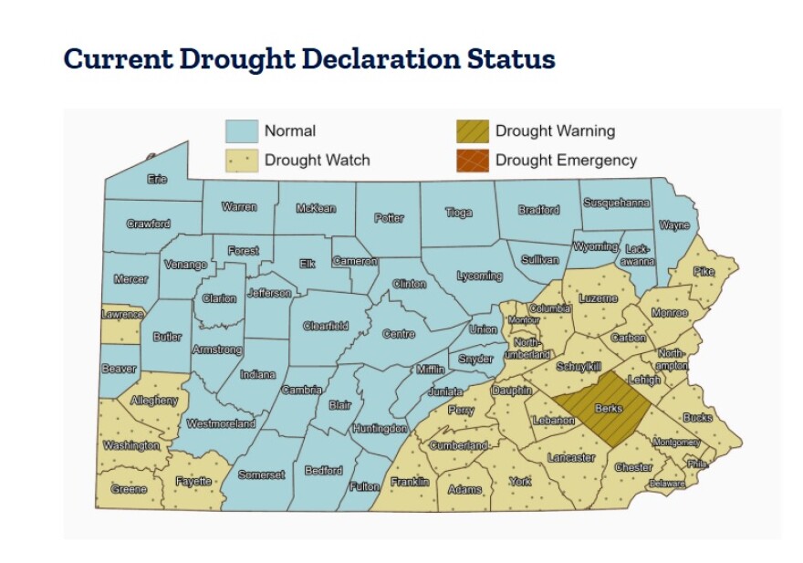
Twenty-five other counties, mainly in the southeastern and southwestern parts of the state, also are in a drought watch.
Currently, the Bethlehem Country Squire Estate in Northampton County is the only public water supplier in the Valley to require mandatory water conservation.
Those requesting voluntary water conservation include: Coopersburg in Lehigh County, as well as Pennsylvania American Water Company’s Berry Hollow and Blue Mountain Division, both in Northampton County.
The U.S. Drought Monitor shows most of the Lehigh Valley either in moderate or severe drought.
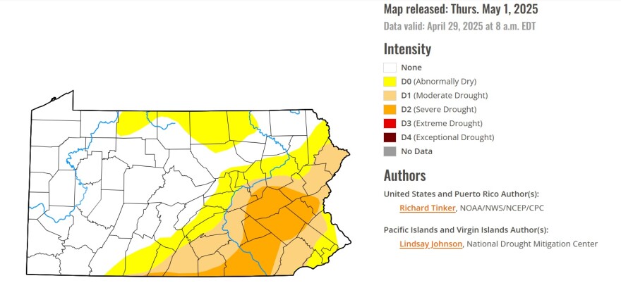
While the two services might seem miles apart in their distinctions, they show different perspectives, Kelleher said.
“The USGS is looking across the entire U.S. and using those broad scale conditions, using information from stream flow, groundwater, precipitation and using that to say something about drought generally across the U.S.,” she said.
“And then, you have the DEP, who's drilled into Pennsylvania, and who is much more familiar with those conditions there, and can sort of say where are those levels where we might need to start taking action as residents or as individuals, operating utilities or things like that.
“I think they sort of work together in some ways — the DEP being sort of the very specific local estimate, and then the USGS being sort of this broad characterization of what's happening across the entire U.S. and how Pennsylvania fits into that.”
It can take some time for both the U.S. Drought Monitor and the state DEP to update their drought maps to reflect recent rainfall.
‘We need some May showers’
Prolonged periods of dry or wet weather aren’t uncommon, Kelleher said, noting that some oscillation is expected.
The question, she said, is if that variation is getting wider because of climate change.
“We expect greater variation from year to year, and we also expect some of the seasonality to shift, too,” she said. “And so, what that means for stream flow and groundwater levels is still uncertain — stay tuned.
“But I think that's part of the longterm expectation, is not just climate warming, but climate weirding.”
“If you look at the short term, we're doing all right. We're a little bit behind, but we're doing all right. We need some May showers — not April showers anymore."Christa Kelleher, a Lafayette College professor and hydrologist
Climate weirding has become a term to describe the unpredictable and extreme weather events, both hot and cold, that have cropped up alongside climate change.
With droughts often more common on the West Coast of the United States, researchers still are grappling with persistent dry periods on the East Coast, and what it could mean long term.
“We don't have enough to say whether it's getting worse,” Kelleher said. “The jury is out on us. The west is a different beast entirely. But, in the east, I think we're still sort of alerting and still gathering information on drought.”
To eliminate the current deficit, the remedy is consistent days of steady rain.
“If you look at the short term, we're doing all right,” Kelleher said. “We're a little bit behind, but we're doing all right.
"We need some May showers — not April showers anymore. The May showers are what we want now.”