-
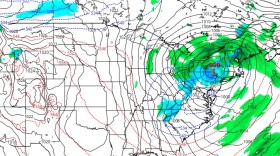
 The National Weather Service has issued a winter storm warning in effect from Thursday afternoon through Friday afternoon for Carbon and Monroe counties in an "elevation-dependent system."
 -
Forecasters are watching a storm system expected to rapidly intensify Wednesday night into Thursday. It could bring more than an inch of rain to the area, and even snow in some locations.
-
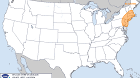
The National Weather Service in Mount Holly issued the warning for gusty winds and low relative humidity, which is in effect from 7 a.m. to 6 p.m. Saturday.
-
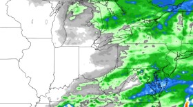
A secondary cold front Tuesday will bring little opportunity for precipitation and another day of windy conditions across the region, forecasters say, setting the stage for risk of fire spread.
-
The last substantial rainfall in the area came Sept. 28, when nearly a quarter-inch fell at the climate station at Lehigh Valley International Airport. Here's why that could make anticipated rainfall Sunday very dangerous for drivers.
-
A ban on open fires in Northampton County will take effect Sunday. Charcoal and propane grills still will be allowed, along with fires in a fireplace or otherwise contained indoors.
-
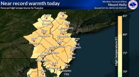
The trend of above-average warmth continued Wednesday, with the National Weather Service reporting several high temperature records tied or broken at climate sites before noon. Thursday will threaten the record books again.
-
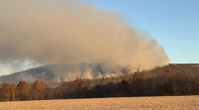
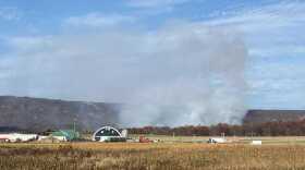
The Gap Fire, which erupted Saturday near Route 248 in Lehigh Township, has drawn hundreds of firefighters over four days. Crews have gotten the upper hand and are now searching for and extinguishing hotspots, officials said.
-
The National Weather Service said there will be “no relief” to ongoing drought and fire concerns, with record-challenging temperatures expected by midweek across the Lehigh Valley and the rest of the mid-Atlantic region.
-
“It will feel more like a mid-to-late August day, with highs in the low to mid 80s under clear skies,” the weather service said in its latest forecast discussion, noting records could fall for climate stations across the region.

Your Local News | Allentown, Bethlehem & Easton
Play Live Radio
Next Up:
0:00
0:00
Available On Air Stations