-
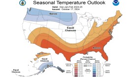
 EPAWA meteorologist Bobby Martrich said, “While the milder outlooks that are out there have merit and support, it’s not as cut and dry as it seems and there can be some surprises, especially earlier in winter.”
 -
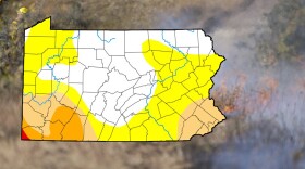
Current conditions in the Lehigh Valley and throughout the region will support the spread of any fires that ignite, the National Weather Service warned Friday. Any fires that erupt could be difficult to control.
-
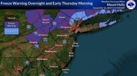
The National Weather has issued a freeze warning in effect from 2 to 9 a.m. Thursday for Berks, Lehigh, Northampton, Carbon and Monroe Counties.
-
Nothing will showcase October as a month of transition quite like the next 24 hours, forecasters say, as temperatures take a dive in the Lehigh Valley.
-
Associated with an unusually strong geomagnetic storm, the northern lights were visible across our area Thursday night, even before the best viewing window advertised by the National Weather Service.
-
The Lehigh Valley is about to experience “a decidedly early November-like day,” according to the National Weather Service. A frost advisory has been issued from midnight to 9 a.m. Friday.
-
Hurricane Milton is expected to heavily disrupt air travel, including flights from Lehigh Valley International Airport to numerous destinations in Florida.
-
Short-term outlooks suggest a cold front will make steady progress across the area Monday, with a reinforcing cold front to follow later this week. It could push overnight temperatures into the 30s for the first time since late April.
-
What can the Lehigh Valley expect as we head into meteorological fall? Experts have given their long-range outlooks for both temperatures and precipitation, and also weighed in on La Niña.
-
The commonwealth's six-week leaf-peeping season has begun. Here's when the Lehigh Valley can expect peak colors.

Your Local News | Allentown, Bethlehem & Easton
Play Live Radio
Next Up:
0:00
0:00
Available On Air Stations