-
 With the system three days away, the weekend will serve as the calm before the storm, with questions remaining on exactly where it will track and how much snow will fall across the region.
 -
While Friday may only bring a dusting to an inch of snow for the Lehigh Valley, forecasters say it could be a sign of things to come. They're watching trends for Monday continue to pull the next system north.
-
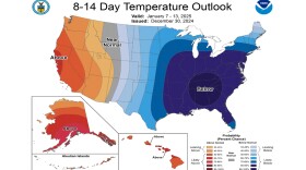
The National Weather Service said Monday the scenario will lead to “exceptionally high probabilities of below-normal temperatures expected across much of the East," but the true intensity of the cold is still unknown.
-
More than 300 Met-Ed customers were impacted by damage to three poles when a tree fell into lines near South Delaware Drive in Easton, which reportedly closed the road as well.
-
A look back to the weather headlines that dominated 2024, and what's to come for the Lehigh Valley. Could a cold and snowy January be on tap?
-
“It doesn’t matter what amount it is, it’s still treacherous on area roadways,” EPAWA meteorologist Bobby Martrich said in his latest video update.
-
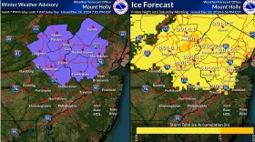
Temperatures will drop below freezing across the area late Friday night and early Saturday, likely setting the stage for a period of freezing rain, according to the National Weather Service.
-
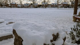
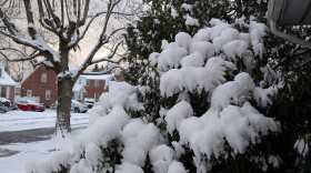
With temperatures in the 20s overnight, snow is expected for the southern Poconos, northern New Jersey and the Lehigh Valley, though accumulations should generally be less than one inch.
-
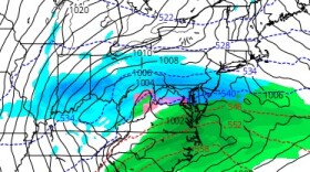
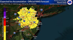
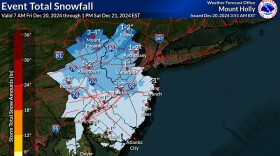
A complex storm system forecasters said could overperform did that and more in the Lehigh Valley on Friday night, as snow totals doubled initial forecasts in some areas.
-
How much snow can we expect Friday? Forecasters say the complex weather system taking aim at the region has resulted in "a difficult and challenging forecast" for the Lehigh Valley and surrounding areas.

Your Local News | Allentown, Bethlehem & Easton
Play Live Radio
Next Up:
0:00
0:00
Available On Air Stations