Stephanie Sigafoos
Managing Producer, DigitalA Lehigh Valley native, I come to LehighValleyNews.com from The Morning Call where I worked more than 14 years in various roles on the digital news team. An Easton (Go Rovers!) and Kutztown University graduate, I live on Allentown’s east side and I’m actively involved in the Midway Manor community group. In my spare time, I also enjoy the local craft beer scene, love to travel and can often be found tracking severe weather. Contact me at StephanieS@lehighvalleynews.com or 610-984-8160.
-
 A man was carjacked at gunpoint Thursday after arranging a deal on Facebook Marketplace to sell shoes to two men, according to court documents.
 -
With the system three days away, the weekend will serve as the calm before the storm, with questions remaining on exactly where it will track and how much snow will fall across the region.
-
The body of Jesse Rutt, of Walnutport, was discovered at 11:34 p.m. in the area of the Slate Heritage Trail in the 300 block of East Church Street.
-
While Friday may only bring a dusting to an inch of snow for the Lehigh Valley, forecasters say it could be a sign of things to come. They're watching trends for Monday continue to pull the next system north.
-
PennDOT District 5 officials say there’s more than $240 million invested into road improvement projects in and around the Lehigh Valley entering 2025.
-
Two decades after the REAL ID Act was introduced, Real ID is about to be real. Federal enforcement finally begins May 7, 2025.
-
The body of an unidentified man was discovered Monday in the water of an underground quarry, the Lehigh County Coroner’s Office said.
-
LehighValleyNews.com’s top stories of 2024 reflect a mix of community concerns, business developments, and breaking news. The stories were selected based on those that were most popular, drawing the most readers this year.
-
The National Weather Service said Monday the scenario will lead to “exceptionally high probabilities of below-normal temperatures expected across much of the East," but the true intensity of the cold is still unknown.
-
More than 300 Met-Ed customers were impacted by damage to three poles when a tree fell into lines near South Delaware Drive in Easton, which reportedly closed the road as well.


-
The state Office of Open Records has ordered the Allentown School District to release records connected to BusPatrol, the contractor responsible for administering the district’s stop-arm camera enforcement program.
-
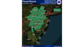
Lehigh and Northampton counties are again under a flood watch, this time from 3 p.m. Wednesday through 3 a.m. Thursday.
-
A 52-year-old Allentown man has died from injuries sustained in a July 4 crash on a scooter, the Lehigh County Coroner’s Office said.
-
In the Lehigh Valley, 22 out of just the last 30 days have seen dew points at or above 70, meaning nearly three-quarters of recent days have been sticky enough to feel more like Florida than eastern Pennsylvania.
-
Pennsylvania state lawmakers have failed to pass a spending plan for the year ahead — more than two weeks past the deadline. This week's Political Pulse looks at what the holdups are.
-
American dream, local reality: Buying a home in Lehigh Valley far from affordable for median earnersNew data shows homebuyers in the Lehigh Valley must spend far above far above the recommended 30% affordability rule. See how the numbers compare to the rest of the nation.
-
Experts say there’s confusion about how quickly heat and moisture can compromise everyday medicines like insulin, inhalers, blood thinners and common antibiotics.
-
A Carbon County woman was killed early Monday in a multi-vehicle crash on Route 309 at Mountain Road, authorities said.
-
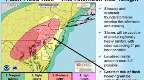
The National Weather Service has issued a flood watch for Lehigh and Northampton counties — along with much of eastern Pennsylvania and parts of New Jersey — from Monday afternoon through the evening.
-
The hotline, created by the Lehigh Valley Emergency Response Network, will serve as a tool for residents to report concerns about U.S. Immigration and Customs Enforcement activity.
-
An unhoused man is facing multiple charges, including attempted homicide, connected to a shooting June 30 in the area of North Morris and West Allen streets in Allentown.
-
Authorities charged Treiza Habib, 63, with leaving an accident scene involving death or personal injury, conspiracy to tamper with evidence, failure to render aid, and failing to report an accident.