

BETHLEHEM, Pa. — If you’ve felt like the air has been a bit thicker than usual this summer, you’re not alone and you’re not imagining it.
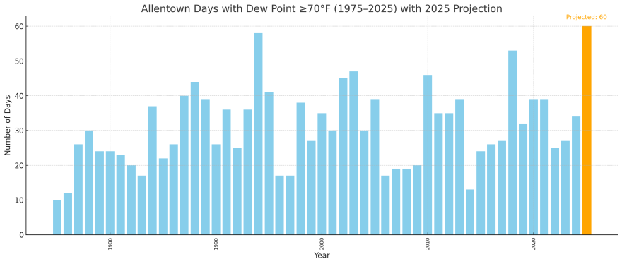
So far in 2025, the Lehigh Valley has already seen 22 days with a dew point of 70 degrees or higher, a level meteorologists use to mark air that feels oppressive and tropical.
That’s 22 days out of just the last 30, meaning nearly three-quarters of recent days have been sticky enough to feel more like Florida than eastern Pennsylvania.
If this pattern holds, the region could be on pace for one of its muggiest summers on record, potentially matching or surpassing the 53 sticky days recorded in 2018, or the 58 days recorded in 1994 — the highest total in local records dating back at least 50 years.
How muggy is muggy?
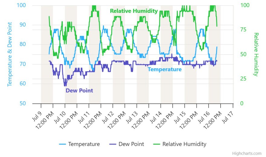
The dew point is a key number meteorologists use to measure how much moisture is in the air. When it climbs above 70 degrees, the air starts to feel oppressive: sweat doesn’t evaporate well, the body can’t cool down as easily, and nights offer little relief.
Since mid-June, these oppressive conditions have become a near daily fact of life across the area. And unlike regular heat waves, high dew points make the heat feel worse and can push the region into dangerous territory for heat stress.
The National Weather Service has issued a heat advisory in effect from 10 a.m. to 8 p.m. Thursday for heat index values up to 100 degrees.
It comes with the temperature at 2 degrees above average for the month thus far (77 degrees through July 15) and weeks after one of the hottest stretches of weather ever recorded in parts of the Mid-Atlantic and Northeast.

A trend decades in the making
Weather records show that muggy days like this have become far more common and last longer into the year than they did decades ago.
Between 1975 and the early 2000s, the Lehigh Valley typically saw about 20 to 40 muggy days per summer. But in recent years, that number has routinely climbed higher.
And now, with more than two months to go before the typical end of the “muggy season” in late September or early October, 2025 could easily top 55 or even 60 muggy days if current trends continue.
A longer, stickier season fuels heavier rain
It’s not just the number of muggy days that are increasing, it’s the length of the season. Over the last few decades, high dew points have arrived earlier in the spring and lingered later into the fall. In some years, like 2010 and 2007, muggy air stretched well into October.
This year, the first 70-degree dew point appeared in early June — right on par with recent sticky summers — but the pace since then has been fairly remarkable: 22 out of the last 30 days have reached that threshold, driving up air conditioning use, stressing energy grids, and increasing the risk of heat-related illness.
They also have helped to fuel heavier downpours, adding to the risk of localized flooding — something the Lehigh Valley and surrounding areas have seen repeatedly during increasingly intense summer storms.
Extreme rainfall Monday triggered flash flooding around the region, with 4.68 inches of rain falling in Emmaus and 4.58 inches in Coopersburg in just a few hours, according to the weather service.
Meanwhile, some parts of New Jersey saw 6.51 inches, prompting officials to declare a state of emergency.
The Weather Prediction Center had the Lehigh Valley and much of the Mid-Atlantic region at a slight risk (2 of 5) of excessive rainfall again Wednesday.
"Unfortunately, it looks like this pattern is going to continue," said Dr. Daniel Swain, a climate scientist at the University of California focused on extreme weather.
"There could be major flash flood risk for days to come in eastern U.S., because this pattern is just going to keep sending tropical moisture northward," he said. (Note: Swain talked to LehighValleyNews.com for an upcoming feature on what's driving more intense storms, and how we're not doing enough to adapt to increasingly intense floods. Look for that story in the coming days)
Why it matters
When overnight dew points stay high, vulnerable residents, especially the elderly or those without air conditioning, face greater risks, experts say. The human body relies on cooler, drier nights to recover from daytime heat, but those cooler nights haven't arrived.
Raw data over the last seven days shows the dew point barely fell below 60, and mostly has trended in the upper 60s to low 70s.
With peak summer humidity often stretching into September, it’s likely Allentown will rack up many more sticky days before this season is done.
If the trend continues, 2025 could be remembered as one of the region’s most tropical-feeling summers yet.
