Bethlehem Live Weather Camera sponsored by St. Luke's University Health Network
-
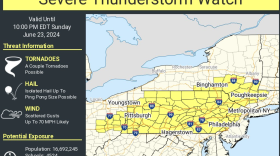
 The severe thunderstorm watch comes amid a heat wave that looks to break Monday as a cooler air mass mercifully moves into the region Sunday night.
 -
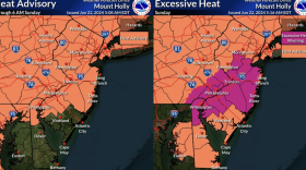
Excessive heat warnings have been posted in parts of the northeastern U.S. with heat indices of 105 to 110 degrees. Forecasters issued an excessive heat warning for southeastern Pennsylvania. As for Saturday, we're expected to hit a high of 96 in the Lehigh Valley.
-
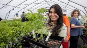
One trick is to be sure to water plants at the base — not the leaves — to ensure the roots absorb the water. "Everybody waters the plant, but you need to water the soil," says one nursery manager.
-
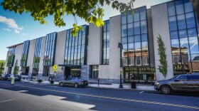
The Lehigh Valley ranks as the eighth-highest industrial market in the U.S., it was disclosed at a Lehigh Valley Planning Commission roundtable meeting on Friday.
-
This week, Megan Frank is joined by environment and science reporter Molly Bilinski, and Northampton County reporter Ryan Gaylor.
-
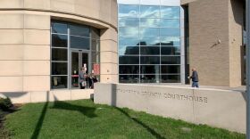
Northampton County Council on Thursday approved nearly $650,000 in Livable Landscapes grants, most focused on expanding or improving the public trails.
-
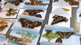
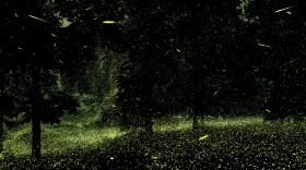
With more than two dozen species of fireflies that call Pennsylvania home, it’s no wonder one was adopted as the state’s insect. But, these flashy insects are threatened due habitat loss and light pollution.
-
The Delaware River Sojourn, an eight-day guided paddling and camping trip, is underway. About 100 paddlers are participating.
-
The U.S. Occupational Safety and Health Administration's General Duty Clause essentially says employees are entitled to a safe and healthy workplace. In some cases, that applies to workers that can endure excessive heat, like during a heat advisory.
-
Looking for relief from the heat in Easton? The city is opening up City Hall and turning on the fire hydrants over the next few days to alleviate the sky-high temperatures.


-
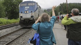
Lehigh Valley Transportation Study officials laid out the next steps to getting the process started for resuming passenger rail service in the Lehigh Valley — if that's what they choose to do.
-
The Da Vinci Science Center in Allentown is reopening next week and showing off a new 67,000-square-foot facility that includes cutting-edge technology and immersive experiences.
-
A program at Rodale Institute aims to develop a diverse pipeline of highly skilled professionals to serve the certified organic industry throughout the state. Pennsylvania is third in the nation for organic commodity sales.
-
East Stroudsburg University’s resident astronomer is leading a stargazing program at Louise W. Moore Park. It's is free and open to all ages 6 and up, but registration is required.
-
The parcel was manifested as “pieces of silk to be used in works." It was seized at Philadelphia International Airport and headed for northeast Pennsylvania.
-
While parts of the Lehigh Valley were able to get a glimpse of the Northern Lights over the weekend, weather conditions kept many from being able to enjoy the show. Now, the solar storm the pushed the aurora to the lower latitudes is waning.
-
WLVR’s Brad Klein reviews the week’s astronomical highlights with Bethlehem’s ‘Backyard Astronomy Guy,’ Marty McGuire. This week it's all about the star Regulus, which is part of the Leo constellation.
-
Christopher Sipos remembers his late-grandmother's love of birds but was pleasantly surprised to find her collection of antique baking soda trading cards that feature the feathered beauties.
-
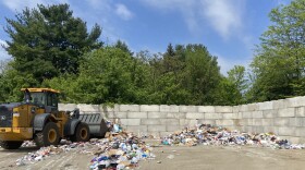
Theis/Cornfeld Recycling Center in Bethlehem accepts recyclables not only from city residents, but the general public, too. There, residents can see how the process works, first-hand.
-
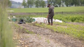
A handful of organic farms across the Lehigh Valley are welcoming residents and visitors this weekend to help their own gardens get growing.
-
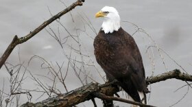
State Sen. Lisa Boscola, D-Lehigh/Northampton, sponsored the bill. Any money collected will go toward bald and golden eagle conservation efforts.
-
Easton City Council heard presentations for improvements intended for Vanderveer and Centennial Parks at their Wednesday meeting, and while the refreshed spaces were well received, the question of cost is still a concern.