Bethlehem Live Weather Camera sponsored by St. Luke's University Health Network
-
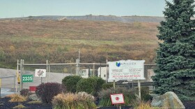
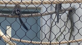
 Officials on Thursday gathered at the Lehigh Valley Zoo, 5150 Game Preserve Road in Schnecksville, for a ribbon cutting for the new Habitat Madagascar exhibit.
 -
The group's goal is to prevent veteran suicides.
-
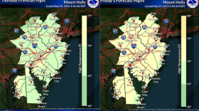
As a high pressure system moves in over the Lehigh Valley, we can expect dry, mostly sunny conditions, at least for parts of the region until Sunday.
-
After clearing more than 40 trees without city approval, college officials must resubmit plans to comply with the city's steep slope conservation ordinance. Failure to do so will halt the project.
-
The spring migration count at Hawk Mountain has ended with counts 25% above the 10-year average.
-
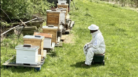
There are more than 400 species of bees in Pennsylvania, but loss of habitat, disease and pesticides have put them at risk, experts said.
-
The county's Livable Landscapes program's priorities include land conservation, ecological restoration, education and outreach, municipal park development and rehabilitation and regional trails.
-
Baby goats, chickens, and even lizards were met with hugs from the seniors, celebrating nursing home week.
-
The Pennsylvania Public Utility Commission (PUC) is alerting consumers to widespread electric price changes.
-
In Pennsylvania, there’s currently no single resource for people to see how counties and local governments plan to spend the money. But understanding the process can help you influence it.


-
While monitoring continues, Lehigh Valley Breathes officials used the most recent project update to explain results from the research this spring at Lehigh University.
-
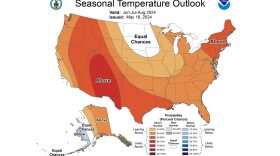
When all was said and done, May was the Lehigh Valley’s sixth consecutive warmer-than-normal month, with an average temperature of 63.4 degrees – or 1.4 degrees above normal. So what will summer bring?
-
Voyager 1 is now the furthest man-made object from Earth, having traveled to a distance of around 15 billion miles away.
-
During this year’s spring migration count, which runs from April 1 through mid-May, Hawk Mountain volunteers and staff tallied 1,001 birds of prey.
-
East Penn School District is seeking proposals for a potential solar farm near the Macungie and Shoemaker Elementary School buildings.
-
Northampton County Park and Recreation Division will host the Greenways Jamboree Celebration, marking their 50th anniversary, in tandem with the 20th anniversary of the Lehigh Valley Greenways Conservation Landscape Partnership and the 28th Annual Lehigh River Sojourn.
-
Three Lehigh Valley researchers are arguing bird-strike fatalities are much higher than we might think. They recently published a peer-reviewed study showing bird deaths from window strikes are nearly double previous estimates, and likely higher.
-
The colleges have formed a partnership to build and bring online a solar facility in western Kentucky. When completed, the facility will offset electricity usage at the institutions, effectively reducing greenhouse gas emissions from electricity generation to zero.
-
The main threat will come later Monday and Monday night with a cold front that creates the possibility of strong winds and hail – even a tornado, said meteorologist Bobby Martrich of EPAWA Weather Consulting.
-
Essentially a scholastic scrimmage for environmental science, the annual Envirothon combines classroom learning and outdoor activities to engage students in the environment. The state competition was held Wednesday at Camp Mt. Luther in Mifflinburg.
-
As residents and tourists explore the region’s many parks, bike trails and scenic overlooks — May is recognized as National Lyme Disease Awareness Month — health and environmental officials are cautioning visitors to check for ticks after their outdoor adventures.
-
A first-quarter log documents over 160 complaints from addresses in Lower Saucon, Hellertown, Freemansburg, Bethlehem Township and the outskirts of Easton. Landfill operators say they're responding.