Bethlehem Live Weather Camera sponsored by St. Luke's University Health Network
-
 Hosted by the Northampton County Conservation District, the Envirothon is scheduled for April 18 at Louise W. Moore County Park. Teams will be tested in a handful of different topics, including wildlife, forestry, soils and land use, aquatic ecology and a current environmental issue.
 -
The Biden administration on Wednesday finalized strict limits on certain so-called “forever chemicals” in drinking water that will require utilities to reduce them to the lowest level they can be reliably measured.
-
The Pennsylvania Museum and Historical Commission will recognize the Allentown State Hospital — which was demolished at the end of 2020 — as a significant part of the Commonwealth’s history by awarding it an Official State Historical Marker.
-
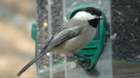
The results of Lehigh Gap Nature Center's 27th annual Lehigh Gap Area Feeder Watch are in. Find out what birds were spotted.
-
An extended view of the total solar eclipse that was promised in the Lehigh Valley on Monday afternoon never materialized due to thick cloud cover, disappointing many of the approximately 1,000 at The Promenade Shops at Saucon Valley.
-
It's solar eclipse day. Here are a few final things to know as we count down to the cosmic spectacle that has been dominating the public consciousness.
-
Despite the cold weather, dozens of anglers showed out to the Little Lehigh Creek in Allentown to mark the first day of trout season in Pennsylvania. The Fish and Boat Commission has been hard at work populating local waters with trout since February.
-
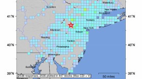
An earthquake rattled the Lehigh Valley and the greater Mid-Atlantic on Friday, with social media instantly blowing up. The U.S. Geological Survey said the earthquake was centered in Hunterdon County, New Jersey — about 35 miles from Bethlehem.
-
A 4.8 magnitude Earthquake in New Jersey was felt throughout the Lehigh Valley Friday morning, but why is that? Meteorologist Matthew Cappucci helps explain how the ancient crust of the east coast played a part in the quake.
-
Looking to throw a solar eclipse party on Monday? Make sure you stock up on some of these awesome eats, including snacks, main courses, and plenty of sweets.


-
Allentown Environmental Advisory Council members on Monday night voted unanimously to submit comments to city officials on a proposed overhaul of zoning regulations, including eight recommendations.
-
Northampton County's Parks and Recreation Division and the Lehigh Valley Greenways Conservation Landscape celebrated big anniversaries Monday during the Greenways Jamboree Monday at Wayne Grube Memorial Park.
-
State officials are holding a virtual town hall meeting Wednesday for residents to share their feedback on the Bureau of Forestry’s newest strategic plan. Here's how to participate.
-
The weather pattern this week will be a tale of two halves, with sunny skies and comfortable temperatures before things heat up in a big way. The region's first heat wave could also be looming, forecasters warn.
-
In this week's Watching the Skies, Brad Klein and Marty McGuire talk about how China landed a spacecraft on the far side of Earth's moon on June 1 to gather rock and soil samples.
-
The release is the first of a long list of fun summer activities planned for young readers at the library.
-
Officials gathered at the Lehigh Valley Zoo Thursday evening for a ribbon cutting to celebrate the opening of Rothrock Red Panda Peak. It's the first time the zoo has had red pandas in residence.
-
The complaint alleges Sunshine Act violations from the township supervisors and legal filings from the township solicitor with no official approval beforehand.
-
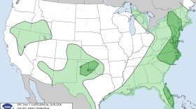
The Storm Prediction Center has maintained a marginal risk (1 out of 5) for the Lehigh Valley and surrounding areas Thursday, with the primary threat being damaging winds.
-
Environmental and county officials this week began dismantling a dam over Bushkill Creek in an effort to restore the creek. The removal will improve water quality, stormwater function and connectivity for fish and other organisms.
-
“The pleasant stretch of weather we encountered early in the week is beyond us,” the National Weather Service said in its latest forecast discussion, with the Lehigh Valley at risk of excessive rainfall Wednesday.
-
After a raging fire on Saturday night destroyed his Center Valley barn, tractors, trucks and equipment, Leroy C. Stahler Jr. vows to rebuild and continue the Stahler family legacy of farming, said his daughter, Tracy Beers.