Bethlehem Live Weather Camera sponsored by St. Luke's University Health Network
-
 The Lehigh Valley Planning Commission last week released a draft of its Priority Climate Action Plan, a document almost a year in the making aimed at tamping down the region’s carbon emissions and mitigating the effects of climate change.
 -
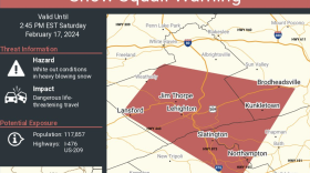
The National Weather Service issued the warning Saturday afternoon for parts of Lehigh and Northampton counties, extending into Carbon County.
-
Take a look at stories that ran throughout the week of which we are most proud, had a profound impact on readers or that you might want to look at again.
-
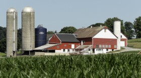
Five farms, three in Lehigh County and two in Northampton County, were the latest to be included in the commonwealth’s Farmland Preservation Program, along with more than a dozen others across the state.
-
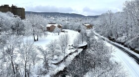
Some areas reported almost 14 inches of snow, with flakes the size of cotton balls. Other areas got just a few inches. Said a National Weather Service meteorologist: 'I completely understand the shock factor.'
-
The Lehigh Valley is under a winter weather advisory in effect from 10 p.m. Friday to 10 a.m. Saturday, with a chance the snowfall that could overperform in parts of the region.
-
WLVR's Megan Frank talks with journalists Molly Bilinski and Phil Gianficaro.
-
Presidents Day weekend is approaching, and historically the period has been prime time for big storms. That won't be the case Friday, but a few inches of snow are possible in the Lehigh Valley.
-
A Lehigh Valley resident was recognized as a “Volunteer of the Year” for 2023 by Keep Pennsylvania Beautiful, a statewide nonprofit that focuses on litter cleanups and community improvements.
-
Less than 24 hours removed from the Lehigh Valley’s heaviest snowfall in three years, forecasters have a word of advice to offer: don’t put the shovel away just yet.


-
The position, budgeted for one year after the annual process turned contentious, focuses on creating and facilitating sustainability initiatives while capturing grant funding to cover the cost of related projects.
-
The start of Lehigh Gap Nature Center’s annual hawk watch is just over a month out, and preparations are well underway. A tradition in its 64th year, volunteers count birds of prey as they migrate along the raptor "superhighway" in the Lehigh Valley’s backyard.
-
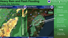
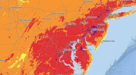
The National Weather Service posted a flood watch starting at 6 a.m. Friday for the Philadelphia region and its suburbs.
-
Funding was awarded through the Lehigh Valley Greenways Mini Grant Program. The program aims to protect and promote natural resources through the implementation of ready-to-go, single-year projects.
-
With other communities around the state adopting bans on plastic bags, Lower Saucon could be on its way to something similar. if approved, it would involve a transition process to show shoppers the bigger picture and give time for businesses to properly offload plastic bags on hand.
-
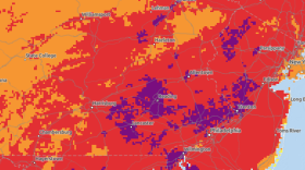
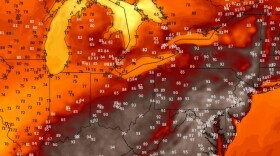
The National Weather Service expanded an excessive heat warning into the Lehigh Valley on Wednesday, calling for dangerously hot conditions with heat index values up to 105 degrees. A severe weather threat will follow.
-
Allentown and Easton have been paired with an engineering company to reduce energy costs and greenhouse gas emissions. It's Allentown's first time, but Easton's second, in the program.
-
As of Tuesday, the Lehigh Valley was suffocating in its thirteenth day of 90-plus temperatures this summer, well on the way to surpassing the average of 14.42 days in the 90s for records that date back to 1912.
-
The Northampton County Coroner has identified an individual who drowned and later died due to complications of drowning after spending time on the Delaware River this past weekend.
-
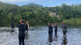
Environmentalists say the Lehigh River is the cleanest its been in 175 years. A river snorkeling program at Lehigh Gap Nature Centers encourages residents to explore their local waterways and track river health.
-
Forecasters: Prepare for an active week of weather hazards, including the approach of Beryl remnantsThe Lehigh Valley will face “an active week in terms of weather hazards,” the National Weather Service said early Monday, with the remnants of Beryl expected to impact the area.
-
This week Watching the Skies explores the ice giant, Uranus.