Bethlehem Live Weather Camera sponsored by St. Luke's University Health Network
-
 Take a look at stories that ran throughout the week of which we are most proud, had a profound impact on readers or that you might want to look at again.
 -
If you're doing anything outdoors, do it Saturday. Rain will arrive Sunday and is forecast to intensify later in the day, with gusty winds. The National Weather Service issued a flood watch for Sunday afternoon into Monday afternoon.
-
LANTA officials are reminding residents for caution when and if severe winter weather returns this season, and discussed what riders should do if they are unsure with the status of service after a storm
-
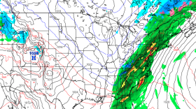
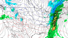
A sprawling storm system is expected to bring heavy rain, strong winds and snow to the region this weekend.
-
Chances are, you'll still be able to find a tree, it just might take a little extra work — and you might want to get it soon. Roger from Unangst Tree Farms explains the ins and outs of why this problem, a decade in the making, is now causing tree farms and stands to sell-out when it's barely December.
-
Almost 11,000 birds of prey were counted this year during the Lehigh Gap Nature Center’s annual autumn hawk watch as they made their way along the raptor "superhighway" in the Valley’s backyard.
-
Snow is in the forecast for the Lehigh Valley, and meteorologists say it could impact the Thursday morning commute. A more potent system Sunday could be 'quite a wild ride.'
-
Emmaus is set to approve the $46 million dollar budget at council's second December meeting, marking a large investment into the borough's management of PFAS contamination.
-
Forecasters say the Lehigh Valley will see a mixed bag of precipitation in the days ahead, with snow showers possible Wednesday and Thursday and a potent storm system expected this weekend.
-
Lehigh Valley Breathes is a Valley-wide effort to monitor air quality amid emissions from trucking and warehousing. The project is expected to run for a year.


-
The Lehigh Valley has been reshaped by a massive wave of development, both in industrial and residential, that has swept over the region the last three decades. While the development boom may be slowing, the impacts to the region’s economy and the environment are clear. (First of 5 parts)
-
After temperatures that felt more like October than August last week, forecasters say the Lehigh Valley will return to summer in a big way this week. Near-record heat is expected Wednesday.
-
The planets Jupiter and Mars will share a small patch of the eastern sky with the crescent moon, and the star Aldebaran on August 27. Here's how to see it.
-
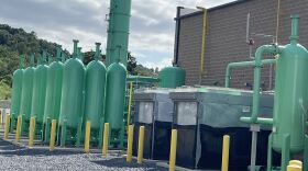
A renewable natural gas plant adjacent to the Bethlehem Landfill opened on Tuesday morning.
-
“We have cooler air coming in," Lehigh Valley meteorologist Bobby Martrich said in his latest update. "Cooler air and refreshing air coming in for the next several days.” How far will temperatures fall?
-
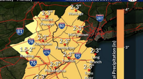
More than 5 inches of rain was reported to have fallen in parts of the Lehigh Valley on Sunday, according to official data from the National Weather Service.
-
The free exhibit, “America’s Beautiful,” at Lehigh Gap Nature Center runs from Aug. 21 to Aug. 29. It includes 50 watercolor paintings of Smokey Bear.
-
More than eight months after announcing a $600 million price tag over the next decade to upgrade aging water and wastewater treatment infrastructure, the Lehigh County Authority is reaching out to major industrial users.
-
A full moon is on display the evening of Monday, August 19. The full moon of each month has one or more traditional names, and the August full moon is known as ‘the Sturgeon Moon.’
-
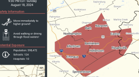
Swaths of the Lehigh Valley were inundated by heavy rainfall on Sunday, leading to flash floods and prompting water rescues. Some areas received nearly 5 inches of rain, with a secondary front set to bring more on Monday.
-
A flash flood warning is in effect for parts of Lehigh and Northampton counties until 11:30 p.m. It follows a line of severe thunderstorms and a flood watch that will be in effect until 2 a.m. Monday.
-
The arrival of a slow-moving system will make for an unsettled weekend, forecasters say, with an excessive rainfall risk and potential flash flooding Sunday for the Lehigh Valley.