BETHLEHEM, Pa. — A sprawling storm system is expected to bring heavy rain, strong winds and snow to the region this weekend, meteorologists warn.
The system is expected to spawn severe weather as a powerful cold front surges into the area.
Forecasters say the wettest and windiest period will be from late Sunday into Monday morning, with snow expected in the higher elevations of the Poconos before the storm pulls away.
The setup
According to the National Weather Service, guidance indicates a coastal front will start developing over the region by early Saturday.
The cool, moist air mass is expected to stall over the region, with warmer air overriding it due to a south to southeast flow.
Daytime highs in the 50s on Saturday will push into the 60s on Sunday as a southerly low-level jet — or a region of strong winds in the lower part of the atmosphere — ahead of the cold front strengthens rapidly.
“This will bring southerly winds which may gust 30 to 40 mph along with increasing coverage of showers and possibly even some embedded thunderstorms,” the weather service said in its latest forecast discussion.
The most active weather is expected after nightfall on Sunday.

The impacts
“If you have anything to do outdoors, make sure it’s done on Saturday and not Sunday,” EPAWA meteorologist Bobby Martrich said in his latest video update.
Martrich said the heaviest rain will be Sunday evening and overnight into Monday.
EPAWA's 12/8 and week ahead outlook, covering:
— Bobby Martrich | EPAWA (@epawawx) December 8, 2023
■ Milder temperatures expected the next several days
■ Latest on the significant late weekend storm system
■ Heavy rain, windy conditions, and a change to snow?https://t.co/AOXYtkzKYG
“That’s when we have the worst conditions, it looks like, for this system,” he said. “It’s going to be primarily rain, however this is a component to this that could be wintry.”
Locations that could see snow include north central Pennsylvania and parts of the Poconos, especially the higher elevations.
For the rest of the region, heavy rainfall is expected as energy maxes out ahead of the approaching front.
The weather service said rainfall totals will likely exceed 2 inches across much of the area, with localized flooding and perhaps some stream/small river flooding.
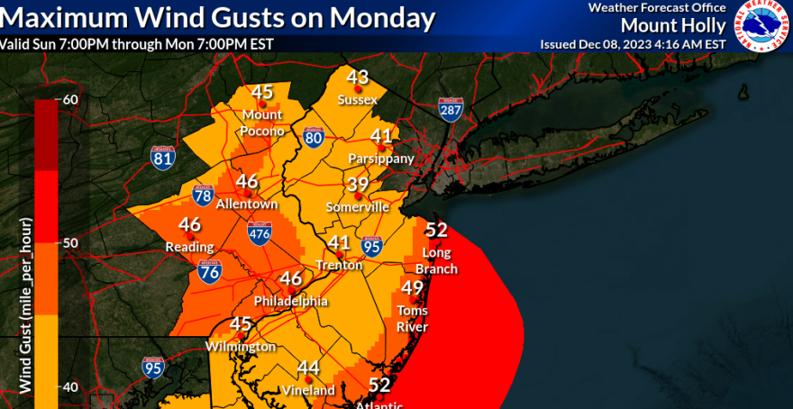
The biggest concern with the storm is a strong blast of wind that may occur as the cold front moves through overnight, with widespread wind advisory gusts possible and perhaps some localized gusts near severe limits. This could pull down tree limbs and cause power outages across the region.
To be considered severe, associated wind gusts must be 58 mph or greater. Those winds are most likely near the coast.
Temperatures are likely to stay in the 50s to low 60s until the front passes, then rapidly drop into the 40s, the weather service said.


