Bethlehem Live Weather Camera sponsored by St. Luke's University Health Network
-
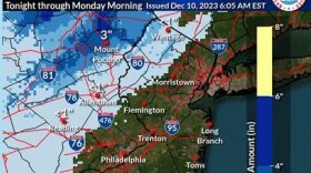
 Many spots could receive 2 to 3 inches of rain, forecasters warn, with areas of flooding possible Sunday night as another coastal storm targets the region.
 -
Amid the joy and festivities, environmental advocates are urging residents to keep sustainability in mind during what can be a time of year when trash and waste spikes.
-
State environmental officials on Thursday evening hosted the last of five public engagement sessions, as they work to create a Priority Climate Action Plan, or PCAP, aiming to reduce greenhouse gas emission statewide and mitigate further effects of climate change.
-
Forecasters say another impactful storm is expected to move up the coast, bringing heavy rain and gusty winds to the region Sunday into Monday.
-
The new official map marks recently acquired land, while setting priorities for future desired open space.
-
A Tuesday evening webinar cosponsored by the Bethlehem Area Public Library and Bethlehem Food Co-Op focused on how residents can meaningfully participate in the city’s efforts to fight climate change.
-
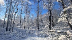
The Lehigh Valley remains devoid of accumulating snow events so far in December —and it looks like that pattern will continue straight through the holiday season.
-
Brad Klein reviews the week’s astronomical highlights with Bethlehem’s 'Backyard Astronomy Guy," Marty McGuire.
-
Sunday's rain could transition to snow as the storm system departs the region Monday morning, with the potential to affect the morning commute, according to the National Weather Service.
-
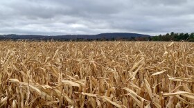
The U.S. Department of Agriculture updated its plant hardiness map, showing a warmer Lehigh Valley. The region has moved into a warmer zone from the one where it was placed more than a decade ago. Experts say it has consequences for plant seasons and species.


-
The Lehigh Valley has been reshaped by a massive wave of development, both in industrial and residential, that has swept over the region the last three decades. While the development boom may be slowing, the impacts to the region’s economy and the environment are clear. (First of 5 parts)
-
After temperatures that felt more like October than August last week, forecasters say the Lehigh Valley will return to summer in a big way this week. Near-record heat is expected Wednesday.
-
The planets Jupiter and Mars will share a small patch of the eastern sky with the crescent moon, and the star Aldebaran on August 27. Here's how to see it.
-
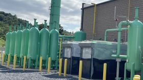
A renewable natural gas plant adjacent to the Bethlehem Landfill opened on Tuesday morning.
-
“We have cooler air coming in," Lehigh Valley meteorologist Bobby Martrich said in his latest update. "Cooler air and refreshing air coming in for the next several days.” How far will temperatures fall?
-
More than 5 inches of rain was reported to have fallen in parts of the Lehigh Valley on Sunday, according to official data from the National Weather Service.
-
The free exhibit, “America’s Beautiful,” at Lehigh Gap Nature Center runs from Aug. 21 to Aug. 29. It includes 50 watercolor paintings of Smokey Bear.
-
More than eight months after announcing a $600 million price tag over the next decade to upgrade aging water and wastewater treatment infrastructure, the Lehigh County Authority is reaching out to major industrial users.
-
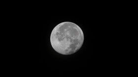
A full moon is on display the evening of Monday, August 19. The full moon of each month has one or more traditional names, and the August full moon is known as ‘the Sturgeon Moon.’
-
Swaths of the Lehigh Valley were inundated by heavy rainfall on Sunday, leading to flash floods and prompting water rescues. Some areas received nearly 5 inches of rain, with a secondary front set to bring more on Monday.
-
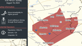
A flash flood warning is in effect for parts of Lehigh and Northampton counties until 11:30 p.m. It follows a line of severe thunderstorms and a flood watch that will be in effect until 2 a.m. Monday.
-
The arrival of a slow-moving system will make for an unsettled weekend, forecasters say, with an excessive rainfall risk and potential flash flooding Sunday for the Lehigh Valley.