Bethlehem Live Weather Camera sponsored by St. Luke's University Health Network
-
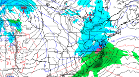
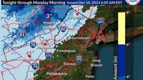
 Many spots could receive 2 to 3 inches of rain, forecasters warn, with areas of flooding possible Sunday night as another coastal storm targets the region.
 -
Amid the joy and festivities, environmental advocates are urging residents to keep sustainability in mind during what can be a time of year when trash and waste spikes.
-
State environmental officials on Thursday evening hosted the last of five public engagement sessions, as they work to create a Priority Climate Action Plan, or PCAP, aiming to reduce greenhouse gas emission statewide and mitigate further effects of climate change.
-
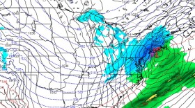
Forecasters say another impactful storm is expected to move up the coast, bringing heavy rain and gusty winds to the region Sunday into Monday.
-
The new official map marks recently acquired land, while setting priorities for future desired open space.
-
A Tuesday evening webinar cosponsored by the Bethlehem Area Public Library and Bethlehem Food Co-Op focused on how residents can meaningfully participate in the city’s efforts to fight climate change.
-
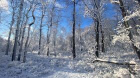
The Lehigh Valley remains devoid of accumulating snow events so far in December —and it looks like that pattern will continue straight through the holiday season.
-
Brad Klein reviews the week’s astronomical highlights with Bethlehem’s 'Backyard Astronomy Guy," Marty McGuire.
-
Sunday's rain could transition to snow as the storm system departs the region Monday morning, with the potential to affect the morning commute, according to the National Weather Service.
-
The U.S. Department of Agriculture updated its plant hardiness map, showing a warmer Lehigh Valley. The region has moved into a warmer zone from the one where it was placed more than a decade ago. Experts say it has consequences for plant seasons and species.


-
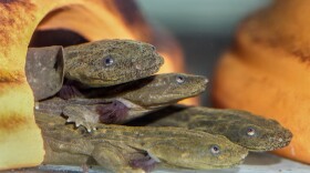
The U.S. Fish and Wildlife Service is considering the eastern hellbender for protections under the federal Endangered Species Act. Find out why habitat loss and the pet trade are contributing to population declines.
-
A new bridge in Lower Saucon Township allows pedestrians to navigate from Hellertown to Quakertown uninterrupted. A grand opening ceremony was held Saturday.
-
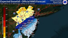
If predictions stay true, the Lehigh Valley would be on the higher end of the 4- to 7-inch range of snowfall. PennDOT and the PA Turnpike Commission have set vehicle and road restrictions.
-
Depending on how the system evolves, a robust and plowable storm seems like the more likely scenario for the region, with the timing on potential snowfall beginning to lock in for Sunday afternoon.
-
Confidence has increased for a clipper system to bring light snow to the region on Thursday, with potential for additional accumulation Sunday into Monday. The coldest air mass of the season arrives behind it, forecasters say.
-
Allentown's EAC accomplished a lot in the past year, including successfully lobbying for two pieces of legislation and supporting a sustainability coordinator for the second year.
-
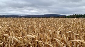
Excelsior Farms was one of nine farms across the state recognized at the 109th PA Farm Show that have been in the same family for 100 years or more.
-
In the current night sky, Venus and Mars both happen to be clear and visible to the naked eye.
-
Join Megan Frank at 9:30 a.m. and 6:30 p.m. every Friday for Insights with LehighValleyNews.com on WLVR. This week, Brittany Sweeney takes her place with reporter Phil Gianficaro and social media specialist Grace Oddo.
-
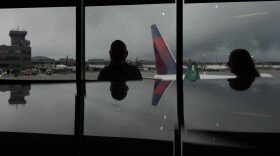
Delta flights to and from Atlanta were among those impacted at Lehigh Valley International Airport on Friday.
-
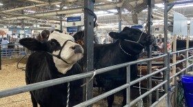
There's plenty to see, and eat, at the PA Farm Show in Harrisburg. Check out our reviews.
-
Just like Monday, which offered little in terms of intense snowfall, Saturday’s wintry weather could essentially be a “non-event” for much of the Lehigh Valley and the rest of the region, the National Weather Service said.