

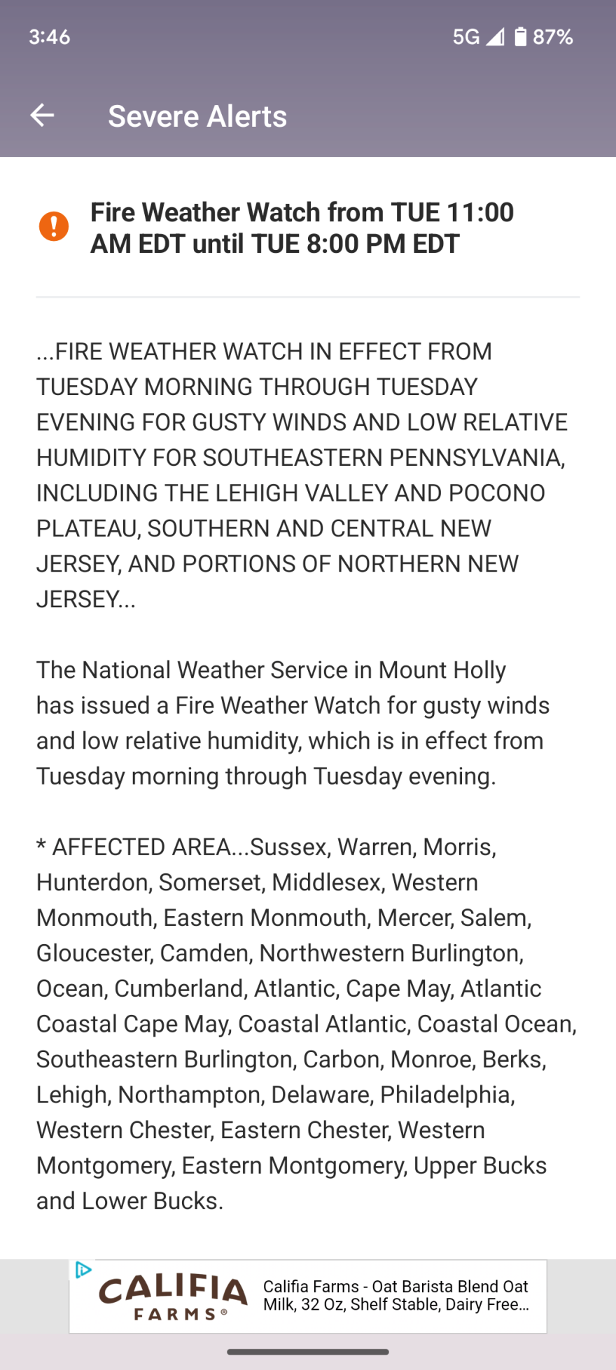
WIND GAP, Pa. — Firefighters battled brush fires around Route 33 in Monroe and Northampton counties on Monday, prompting the closure of southbound Route 33 in Wind Gap.
"We had numerous fires along [Route] 33 expanding miles of territory, and dozens of fire companies to assist in extinguishing the fires along with DCNR, the parks service, and fish and wildlife," said Leon Clapper, fire chief of Blue Ridge Hook and Ladder Company in Hamilton Township, Monroe County.
- A brush fire closed Route 33 South in Wind Gap on Monday
- Dispatchers reported fire was near the highway in Northampton and Monroe counties
- The fire comes as the Lehigh Valley endures a dry stretch of weather out of its second-driest May on record
Clapper said other fires have been put out, and one near Wind Gap was the last that remained to be extinguished by mid-afternoon.


Northampton County Dispatch confirmed Route 33 Southbound was closed at Route 512 just after noon due to fire department activity, with fire reported near the highway.
Pennsylvania State Police Trooper Nathan Branosky tweeted the fire was "causing visibility issues" and that all traffic was exiting Route 33 Southbound at the Wind Gap exit.
All traffic on SR 33 SB is exiting the Wind Gap exit @NorthamptonExec County due to a fire in Wind Gap which is causing visibility issues. All traffic on SR 33 NB remains open. @LVNewsdotcom @lehighvalley @mcall @69News @PSPTroopNPIO pic.twitter.com/gYsCM1I9aS
— Trooper Branosky (@PSPTroopMPIO) June 5, 2023
Route 33 Northbound remained open, Branosky said.
On Facebook, the Forks Township Fire Department said it was assisting Plainfield Township Fire Department with the brush fire.
Traffic on Route 33 was backed up more than seven miles through Saylorsburg.
The area was under a moderate risk of forecast fire danger on Monday, in a map updated by the Pennsylvania Department of Conservation and Natural Resources.
Dry weather and gusty winds have increased the wildfire risk across Pennsylvania, including the Lehigh Valley.
The U.S. Forest Service also uses the Wildland Fire Assessment System to measure wildfire risk, closely monitoring temperatures, wind speed, relative humidity and precipitation chances to create a daily fire weather map.
Brush fires will continue to be a concern due to an extended stretch of dry weather that has led to drought conditions in the Lehigh Valley and beyond.
In a map released Thursday, nearly the entire state of Pennsylvania was designated as “abnormally dry” by the U.S. Drought Monitor. The status is a precursor to drought and is likely to worsen over the next couple of weeks.
With just under a quarter-inch of rain, the Lehigh Valley recorded its second-driest May ever, behind only the 0.09 inches recorded in May 1964.
