

BETHLEHEM, Pa. – An extended stretch of dry weather has led to drought conditions in the Lehigh Valley and beyond.
In a map released Thursday, nearly the entire state of Pennsylvania was designated as “abnormally dry” by the U.S. Drought Monitor. The status is a precursor to drought and is likely to worsen over the next couple of weeks.
With just under a quarter-inch of rain, the Lehigh Valley recorded its second-driest May ever, behind only the 0.09 inches recorded in May 1964.
- The Lehigh Valley and most of Pennsylvania are now classified as abnormally dry by the U.S. Drought Monitor
- It comes after the area's second-driest May on record
- Long-range patterns show there are enhanced odds of below normal precipitation for the next 10 days, and possibly longer
Normal precipitation for the month is 3.28 inches.
In a summary of existing conditions, experts with the U.S. Drought Monitor wrote, “With soils drying, low streamflow, and very low precipitation for the month of May, D0 (abnormal dryness) expanded across much of the region, from Delaware, Maryland and West Virginia to southern New York, and from western Maine to western Massachusetts.”
There are 90-day precipitation deficits in Maryland and parts of eastern Pennsylvania that prompted a D1, or moderate drought status.
The U.S. Department of Agriculture rated 80% of the topsoil moisture in the state as short or very short (dry or very dry), an increase of 48% week-to-week. The values were 100% for New Jersey, 78% for Maryland and 52% for New York.
Measuring drought
Droughts are measured not just by rainfall, but by a number of other factors including stream flow, groundwater level, precipitation, and soil moisture.
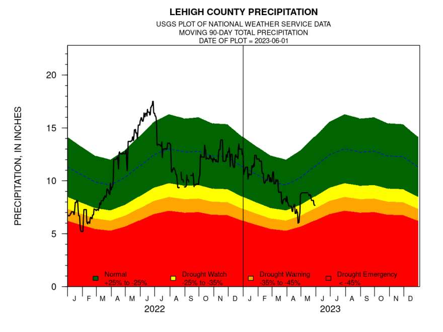
Pennsylvania drought condition monitoring indicators provided by the U.S. Geological Survey show deficits in two of the four indicators in Lehigh County and one of the four indicators in Northampton County.
In Lehigh County, the 90-day precipitation and surface water indicators have fallen to drought watch levels (indicated in yellow in the graphic below) and are heading toward drought warning status.
The pattern ahead
The National Weather Service says a cold front expected to move through the region this weekend does not look like a widespread precipitation event, though some areas are expected to pick up some rainfall.
Long-range patterns from the government’s Climate Prediction Center say there are enhanced odds of below normal precipitation for the next 10 days, an assessment local meteorologists agree with.
“For the first 10 days of June, no. There’s little chance of rain,” said EPAWA meteorologist Bobby Martrich. “The stuff that’s coming through Saturday … every little bit helps, but it’s not going to be overly worthwhile.”
EPAWA's 6/1 and week ahead outlook, covering:
— Bobby Martrich | EPAWA (@epawawx) June 1, 2023
■ Very warm/hot for the interior next two days
■ Backdoor cold front moves through Saturday
■ Expectations of showers/t-storms this weekhttps://t.co/5xPPwdrRcV
Martrich said we can expect a “quick line” of showers early Saturday afternoon, perhaps with some embedded storms in spots. But the precipitation will not be particularly heavy.
“Usually backdoor cold fronts don’t get too excited with storms,” he said, nothing people with outdoor plans Saturday shouldn’t cancel them.
But Martrich said things could turn around – somewhat – after June 10.
“The problem right now is big ridging that’s been sitting over eastern Canada and hasn’t been moving. There are signs that it’s going to be breaking down, most notably around the second week of June,” he said.
The pattern the models agree on wouldn’t bring a deluge of rain or make up existing deficits, but they would bring something of a more typical pattern for rainfall.
“For the long range, you’re looking at (chances for above average rainfall) maybe the tail end of June and early July,” Martrich said. “But you’re looking at an ensemble that goes out 40 to 45 days and there’s a lot of factors that go into it.
“If there’s a moderate El Nino in place it’s wetter and slightly warmer – that hot, humid muggy stuff in July and August.”
But Matrich cautioned the long-term “is not just if A, then B. But it should eventually be leaning toward the wetter side of average.”
