
BETHLEHEM, Pa. — The intricacies of an upcoming winter storm made for a low confidence forecast coming into the weekend, but the details are being ironed out.
A winter storm watch has been issued for the Lehigh Valley from 12 a.m. to 6 p.m. Tuesday for 4 to 8 inches of heavy, wet snow.
The watch was issued hours after the National Weather Service said areas from at least the I-78 corridor northward should be prepared for plowable snow Monday night through Tuesday morning.
It will be the area’s first real measurable snowfall since it measured 1.6 inches on January 19, though a trace of snow was measured Feb. 2.
The setup
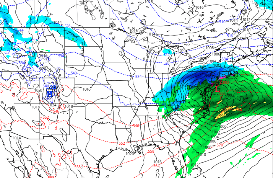
The setup involves a storm system set to track up the Appalachians on Monday night, followed by a transfer to a rapidly intensifying coastal low by Tuesday morning.
Early Saturday, the weather service said most of the modeling seemed to be settling on the low developing across eastern Virginia and tracking east-northeast quickly across the Delmarva and south of Cape May, then southeast of Cape Cod by Tuesday evening.
“Perhaps more critically, models have closed in on a solution that keeps the closed low tracking south of most of our area,” the latest NWS forecast discussion said.
In this setup, a rain/snow line will develop as the storm moves into the area, perhaps holding around I-78 Monday night before sinking southward Tuesday morning as the coastal low takes over and draws in colder air.
What could cut down snow totals
As the models continue to wobble north and south, a few key issues could potentially cut down snow totals for the Lehigh Valley.
The airmass ahead of the storm is relatively mild, with daytime highs near 50 degrees expected Monday before the storm arrives.
But easterly surface winds will turn as the coastal low takes over, and those winds will quickly back to the northeast and north Tuesday morning, the weather service said. That will create a “cold conveyor belt” of precipitation wrapping back across much of the region.
This means that while temperatures may initially be marginal for snow, as heavier precipitation moves in overnight along with stronger forcing, the Lehigh Valley will see a flip to snow, while areas to our north are likely to see snow for the bulk of the event.
The latest ensemble guidance early Saturday suggested 4 to 8 inches north of I-78, while probabilities around Philadelphia for greater than 4 inches were only around 15%.
EPAWA's 2/10 and week ahead outlook, covering:
— Bobby Martrich | EPAWA (@epawawx) February 10, 2024
■ Mild temperatures remain through the weekend
■ Breakdown of the early next week storm system
■ Rain to snow, some significant in interior localeshttps://t.co/0mOklUmwmW
Most guidance suggested a slushy inch or two along the I-95 corridor, and there remains a high degree of uncertainty about how much snow could fall from I-95 to I-78.
“The question is, how much precipitation is left when you get that changeover?” EPAWA meteorologist Bobby Martrich said in his Saturday update, noting the Lehigh Valley and other interior locations could be dealing with a moderate to significant snowfall.
Martrich put the axis of snowfall between I-78 and I-80 and said, "That's probably your heaviest snow axis with this particular system."
