BETHLEHEM, Pa. — A majority of Pennsylvania, including most of the Lehigh Valley, has moved into a drought.
At least that’s the word from the U.S. Drought Monitor’s weekly report.
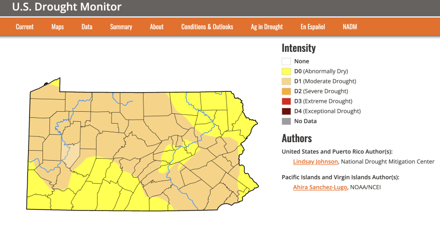
- The U.S. Drought Monitor's latest map was issued Thursday
- It shows most of Pennsylvania moving into the first stage of drought status — an escalation from 'abnormally dry'
- Rain is in the Lehigh Valley forecast for Monday and Tuesday
Its latest map, issued Thursday, shows a swath of Pennsylvania crossing from the southeast to northwest in a moderate drought.
It’s the first stage of drought and a step up from the abnormally dry stage, which you probably noticed from the splotches of brown grass in your yard or coatings of crust on your car.
Previously, nearly all of Pennsylvania was “abnormally dry” — a status designated by the U.S. Drought Monitor as a precursor to drought.
The Slate Belt is the only region of the Lehigh Valley still classified as abnormally dry.
May was particularly parched, with the Lehigh Valley recording less than a quarter-inch or rain. It was the second-driest May ever, behind only the 0.09 inches recorded in May 1964. Normal precipitation for the month is 3.28 inches.
June so far has been all but rain-free.
While most attention this week has focused on Canadian wildfire smoke that has infiltrated the Northeast, producing hazardous air quality for millions, drought conditions have persisted.
In a summary of existing conditions, experts with the U.S. Drought Monitor wrote this about the Northeast:
“More generally over the last few weeks, especially across the western half of the Northeast, streamflows and soil moisture are very low, amid unusually hot temperatures and high evaporative demand for this time of year. As a result, drought and abnormal dryness expanded across much of the western half of the region, especially from western New Jersey through Pennsylvania and New York, as well as northern Virginia and eastern West Virginia.”
READ: The haze and your health: What to do to stay safe while wildfire smoke lingers
WATCH: Live Lehigh Valley weather cam
There are glimmers of hope — that the smoke will clear and that significant rainfall is coming our way.
All of Pennsylvania, as well as New York, New Jersey and Washington, D.C., fall under an excessive rainfall outlook early next week by the National Oceanic and Atmospheric Administration.
The National Weather Service says Canadian wildfire smoke should start clearing out this weekend and Monday should be "the final end of the smoke and hazy conditions across the region."
Air quality continues to range from 'unhealthy' (red) to 'hazardous' (maroon) this morning (via https://t.co/cDxnt4ugEL).
— NWS Mount Holly (@NWS_MountHolly) June 8, 2023
You can find out what the air quality index colors mean, & what actions to take here: https://t.co/41TUgKGpKQ pic.twitter.com/7IrLORMLsK
A front is forecast to bring widespread and much-needed rainfall.
Lehigh Valley-based meteorologist Bobby Martrich of the Eastern PA Weather Authority said a half-inch to an inch of rain can be expected — not enough to eliminate rainfall deficits but “a step in the right direction."
“I think the excessive rainfall outlook is more tied to the fact that it’s so dry, so it may be hard to absorb initially,” he told LehighValleyNews.com. “...But the fact that it’s going [to rain] over at least 12 hours, if not more, is ideal.”
The U.S. Drought Monitor maps are produced jointly by the National Drought Mitigation Center at the University of Nebraska-Lincoln, the National Oceanic and Atmospheric Administration and the U.S. Department of Agriculture.