
- NOAA released its official 2023-24 winter outlook on Thursday
- Experts addressed the possibility of a "super" El Niño and its impact on the winter season
- "There's some hope for snow lovers," said Operational Branch Chief Jon Gottschalck
BETHLEHEM, Pa. — As the National Oceanic and Atmospheric Administration released its official 2023-24 winter outlook Thursday, conversation turned to the possibility of a “super” El Niño.
Would the climate pattern observed this winter might be one of the strongest in the historical record?
Experts on the call, including NOAA’s Operational Branch Chief Jon Gottschalck, said they’re favoring a “low strong end event,” and stronger El Niños increase the likelihood of related climate anomalies, but don't necessarily equate to strong impacts locally.
“No Two El Niños are alike. It’s a reminder that it won’t always match the past.”NOAA Chief Scientist Sarah Kapnick
“It’s unclear whether [the strength] will increase to match some of the strongest El Niño events,” Gottschalck said.
He emphasized that variation among each event makes potential weather impacts difficult to predict.
But climate happenings documented during previous strong El Niños point to the possibility of an active winter season, and experts agreed the coming winter could mean a strong enough El Niño that it might rival years such as 2009-10.
“No Two El Niños are alike,” Chief Scientist Sarah Kapnick said. “It’s a reminder that it won’t always match the past.”
An outlook 'probabilistic in nature’
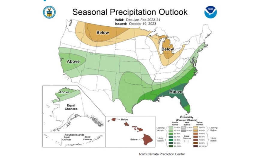
NOAA’s forecast covers the months of December, January and February, or what is known as meteorological winter. It predicts only where above- or below-normal temperatures — and above- or below-normal precipitation — are most likely.
What it doesn’t predict is the one question everyone is asking in the lead up to the season: How much snow will fall?
To that end, NOAA’s Climate Prediction Center favors warmer-than-average temperatures across the northern tier of the United States and much of the Far West, along with wetter-than-average conditions for northern Alaska, parts of the West, the southern Plains, Southeast, Gulf Coast and lower mid-Atlantic — with a sharp cutoff in the Lehigh Valley area.
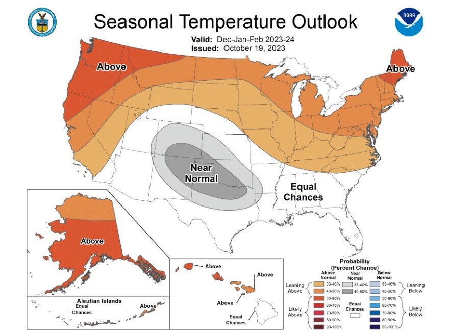
Drier-than-average conditions are expected across the northern tier of the United States, especially in the northern Rockies and High Plains and near the Great Lakes.
“The winter outlook is probabilistic in nature … it means that other outcomes are always possible, just less likely,” Gottschalck said.
Will we see another 'Snowmaggedon?'
The Lehigh Valley has already endured repeated rounds of precipitation this fall – including a number of coastal storms that have targeted the region and made for some rather wet weekends.
Experts expect that pattern to prevail in the coming months.
"I think the repeated rounds of moisture will continue," EPAWA meteorologist Bobby Martrich said.
"I am not agreeing [on the idea] that it will become a super El Niño. Our snowfall and whether we are mild or frequently colder will depend on where the warmest waters are in the eastern Pacific.
"If it is east-based in winter like it is now and it doesn't spread out evenly across the multiple El Niño regions, then not much snow. But I think this is for now following a 2014-15 pattern at least in the fall. So my bets are that we have more than average [snow] this year."
"There’s some hope for snow lovers."NOAA Operational Branch Chief Jon Gottschalck
The experts on Thursday's call agreed.
“One of the biggest impacts of a strong El Niño is a subtropical jet stream that allows access to more moisture from the Pacific and the Gulf of Mexico and Caribbean,” Gottschalck said.
“These storms get very juiced up, meaning if they’re in timing with cold air, these storms can really explode off the East Coast. There’s a very sharp gradient in temperature and moisture fueling these storms.
"As far as frequency, it's very hard to say but typically there are two to three big snowstorms on average. Every season is different.”
With that, Gottschalck referenced “Snowmaggedon” — the storm that walloped the region in February 2010.
He said in this winter outlook, "There’s some hope for snow lovers."
