
BETHLEHEM, Pa. — The National Weather Service said Wednesday graupel is in the Lehigh Valley forecast as scattered showers develop and move across the region.
The frozen precipitation is expected as the radar becomes a little more active in the late morning to afternoon hours. That’s when an upper-level low — a pool of relatively cold air in the atmosphere also known as a cold-core low — moves overhead.
But what is graupel and how is it different from other forms of frozen precipitation?
Another cool day with clouds and scattered showers lies ahead for Wednesday. Don't be surprised if you see some small hail or graupel in some of the showers this afternoon. #PAwx #NJwx #DEwx #MDwx pic.twitter.com/v3Z5aPSgQw
— NWS Mount Holly (@NWS_MountHolly) May 3, 2023
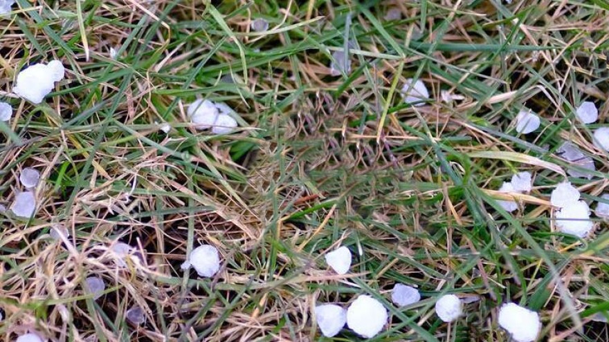
Graupel, in a nutshell
According to NOAA’s National Severe Storms Laboratory, the primary difference between graupel and other types of wintry precipitation is how they grow and how they’re sized.
Graupel are soft, small pellets formed when supercooled water droplets (water with a temperature below 32 degrees) freeze onto a snow crystal in a process called riming.
“If the riming is particularly intense, the rimed snow crystal can grow to an appreciable size, but remain less than 0.2 inches,” NOAA’s explainer says.
By comparison, hail is generally measured this way:
- Pea = 1/4 inch diameter
- Mothball = 1/2 inch diameter
- Penny = 3/4 inch diameter
- Nickel = 7/8 inch
- Quarter = 1 inch — hail quarter size or larger is considered severe
- Ping-Pong Ball = 1 1/2 inch
- Golf Ball = 1 3/4 inches
- Tennis Ball = 2 1/2 inches
- Baseball = 2 3/4 inches
- Tea cup = 3 inches
- Softball = 4 inches
- Grapefruit = 4 1/2 inches
So graupel is snow?
You might hear forecasters refer to graupel as “snow pellets” or “soft hail,” but it’s not snow and it’s not hail. It’s also not sleet.
According to the weather service, it’s just referred to this way because graupel is snow that melts and becomes supercooled. But as it falls through a warm surface and forms ice pellets, it takes on the appearance of a tiny white pellet.
Like a snowflake, graupel particles are fragile and generally melt when handled.
Why is there a chance of graupel now?
While Mother Nature has been moody this week, there’s no severe weather in the forecast. Just cold and winter-like temperatures and the right atmospheric conditions.
It comes as the center of that persistent low pressure responsible for our weather the past few days finally begins to slide off to our east. Forecasters say we’ll see that by Thursday, and it will accelerate further offshore by Friday morning.
Where did graupel get its name?
According to Merriam-Webster, the word graupel [GRAW-pull] is Germanic in origin and is derived from “graupe” – the word for pearl barley.
Reportedly, graupel first appeared in a weather report in 1889 and has become the standard to describe "soft hail."
When will this pattern finally end?
Meteorologists say temperatures will be on a slow upward trajectory as the core of the cold air exits the region. We can expect daytime highs in the low 60s on Thursday and the mid-60s on Friday.
It also looks to be a pleasant weekend, with dry weather returning and temperatures continuing to moderate toward climatological normals, the weather service said.
That means we’ll reach the upper 60s on Saturday and the low 70s on Sunday.
