

BETHLEHEM, Pa. — It’s not unprecedented, but it's a little bit too early for the kind of warmth the Lehigh Valley will see next week, meteorologist Bobby Martrich of EPAWA Weather Consulting said.
How warm will it get?
We’ll likely see near-record highs, Martrich said, even as the region is stuck on the cool side of a front that will keep temperatures in the 50s through Easter weekend.
- After temperatures in the 50s through the holiday weekend, the heat is on
- Forecasters say the Lehigh Valley will challenge record highs next week
- The upcoming pattern also will be drier than normal
After that, guidance continues to suggest that the long-term period will end up feeling more like mid-June than mid-April in the Lehigh Valley.
“The notable period of warmth will be most exceptional between April 12th to 15th,” Martrich said, describing temperatures likely to push into the 80s.
It all has to do with anomalous ridging in the eastern half of the country, while the western United States is cooler, Martrich said.
“The position of the jet stream is such that it is far to the north, allowing anomalously warm temperatures to settle in next week over a several-day period,” he said.
In that setup, warmer air flows northward into the upper Midwest and Northeast.
How Long Will The Warmth Last?
EPAWA's 4/7 and week ahead outlook, covering:
— Bobby Martrich | EPAWA (@epawawx) April 7, 2023
■ Much cooler temperatures thru the weekend
■ Turning warmer next week, and in a big wayhttps://t.co/wDuHfZIxJU
While wild temperature swings are fairly typical in early spring, this one could challenge records.
The normal high on April 13 in Allentown is 63 degrees, and we’re talking about a high of maybe 83 or 84 degrees for that day, Martrich said.
The record high in Allentown on April 13 is 88 degrees, set in 1941.
“It does look like temperatures come back down closer to reality by [next] Sunday, but would still be warmer than average,” Martrich said.
Other experts agree
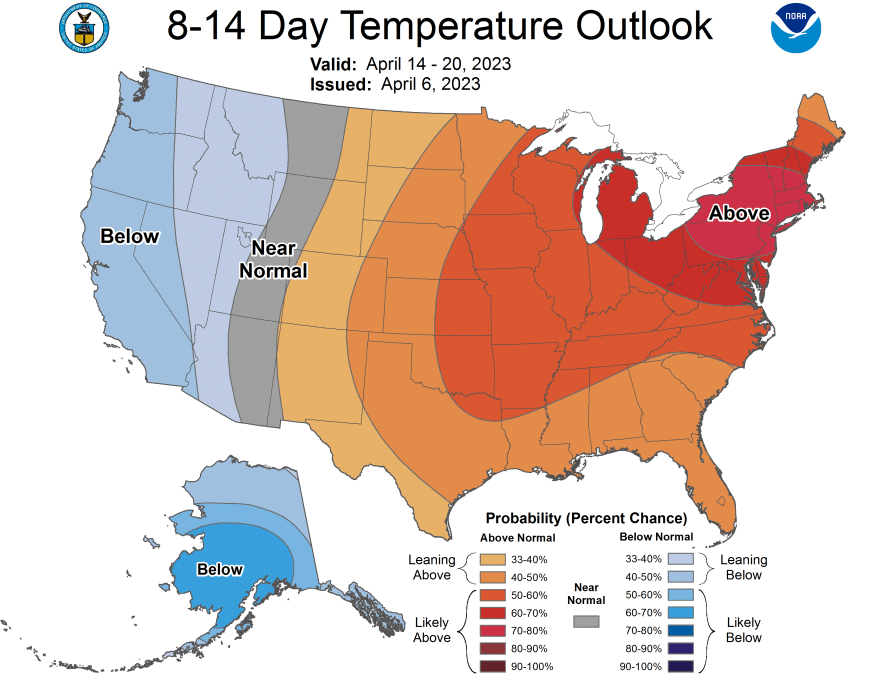
NOAA’s Climate Prediction Center said while it expects cooler weather to work its way back into much of the West, warm weather is forecast to last into much of the following week in our area.
The eight-to-14 day outlook projects above-average temperatures in the Lehigh Valley through at least April 20, with good forecast confidence.
“The strong mid-level ridge … will bring significantly above-normal temperatures,” a prognostic discussion said, mentioning odds exceeding 90% from the eastern Great Lakes to the New Jersey and New York coastlines.
Odds also favor drier than normal weather, which isn’t great for the Lehigh Valley.
Parts of the region are once again classified as “abnormally dry” by the U.S. Drought Monitor and are seeing precipitation deficits, low stream flows and pockets of below-normal soil moisture.
