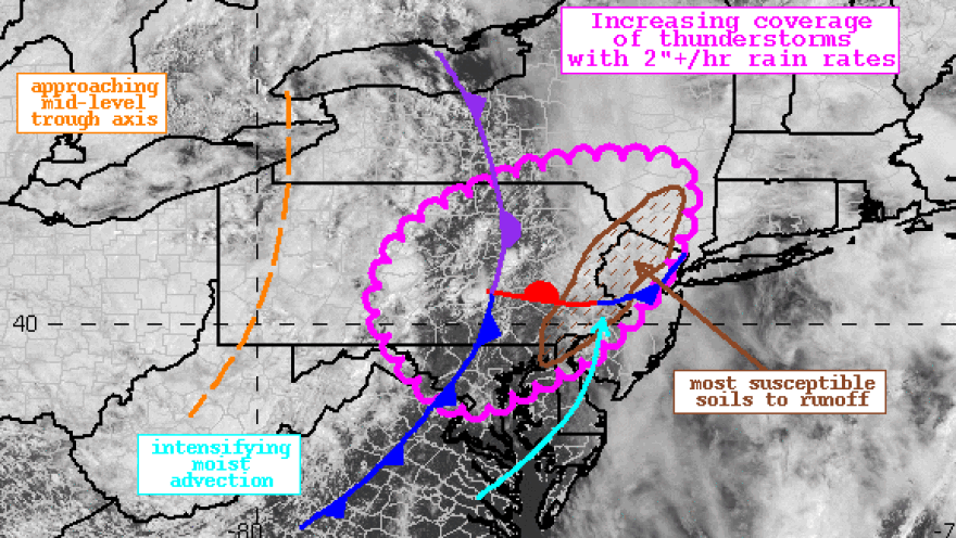
BETHLEHEM, Pa. – Severe storms brought hail and damaging winds to the Lehigh Valley on Monday, but they also brought torrential rain.
Now, more storms are on the way.
The Weather Prediction Center warned early Tuesday afternoon of "showers and thunderstorms blossoming within a warm sector that will increase in coverage this afternoon." A forecast discussion said rainfall rates will exceed two inches per hour, and some areas could see 2-3 inches of rain with higher amounts in isolated areas.
"Flash flooding is possible," the discussion said, warning of "intense rainfall rates."
Several instances of flooding remain possible Tuesday, especially in urban and poor-drainage areas and near vulnerable small creeks and streams.
#WPC_MD 0595 affecting Portions of the Mid-Atlantic from Maryland through southeast Upstate New York, #nywx #njwx #pawx #dewx #mdwx #dcwx #vawx #wvwx, https://t.co/J4WQEBH6GK pic.twitter.com/kFs1ewms5s
— NWS Weather Prediction Center (@NWSWPC) June 27, 2023
- Parts of the Lehigh Valley received more than 4 inches of rain on Monday
- A flood watch is in effect from noon through Tuesday evening
- Additional rainfall is likely, with a few stronger storms capable of locally damaging wind gusts and hail
A flood watch remains in effect through the evening, with excessive runoff likely to result in flooding of low-lying and flood-prone areas, according to the National Weather Service.
The watch comes with scattered showers and thunderstorms with locally heavy rain expected across the region for a second straight day.
1:00am CDT #SPC Day1 Outlook Enhanced Risk: FROM SOUTHERN KS/NORTHERN OK INTO EXTREME NORTHWEST AR/SOUTHWEST MO https://t.co/TgJgC6cQZw pic.twitter.com/tnXxAfvAkB
— NWS Storm Prediction Center (@NWSSPC) June 27, 2023
Widespread rainfall amounts of 2-4 inches occurred on Monday, heavily saturating the ground, and rainfall amounts of 1-2 inches with localized amounts near 3 inches are possible Tuesday.
WATCH: Bethlehem live weather camera
The Lehigh Valley is at a marginal (1 out of 5) risk of severe weather, with scattered thunderstorms expected again along and east of a cold front.
“Modest instability may support a few stronger storms capable of locally damaging wind gusts and possibly some marginal hail,” according to the Storm Prediction Center.
Some locations that experienced flooding Monday afternoon and evening and could experience additional flooding include:
- Interstate 78 in Pennsylvania between mile markers 59 and 76.
- Interstate 78 in New Jersey between mile markers 0 and 40.
- Interstate 80 in New Jersey between mile markers 0 and 47.
- Interstate 80 in Pennsylvania near mile marker 314.
- Interstate 287 in New Jersey between mile markers 14 and 53.
- Northeast Extension of the PA Turnpike between mile markers 47 and 51.
Monday’s rainfall totals
The region had been in drought and running a deficit in the rain column, but things changed in a big way on Monday for some parts of the Lehigh Valley.
Here are the rainfall totals reported to the weather service:
Lehigh County
Center Valley 3.49 in
South Bethlehem 2.14 in
NE Lynn Twp 1.66 in
Fogelsville 1.58 in
Coopersburg 1.55 in
Whitehall 1.53 in
Trexler 1.45 in
Germansville 1.23 in
Bethlehem 1.18 in
Lehigh Valley Int’l Airport 1.12 in
Northampton County
Martins Creek 4.60 in
Easton 4.53 in
Forks Twp 4.37 in
Martins Creek 2.87 in
Bethlehem 2.51 in
Bethlehem 2.40 in
Bethlehem Twp 1.56 in
Northampton (MS) 1.31 in
Nazareth 1.13 in


